Chepping Wycombe

Last updated

Chepping Wycombe
Green Dragon, Flackwell Heath - geograph.org.uk - 2187471.jpg
Green Dragon, Flackwell Heath, 2010
Buckinghamshire UK location map.svg
Red pog.svg
Chepping Wycombe
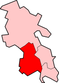
Location within Buckinghamshire
Population14,455  [1]
14,648 (2011 Census) [2]
OS grid reference SU905908
Civil parish
  • Chepping Wycombe
Unitary authority
Ceremonial county
Region
Country England
Sovereign state United Kingdom
Post town High Wycombe
Postcode district HP10
Dialling code 01494
Police Thames Valley
Fire Buckinghamshire
Ambulance South Central
UK Parliament
List of places
UK
England
Buckinghamshire
51°36′29″N0°41′50″W / 51.6081°N 0.6972°W / 51.6081; -0.6972 Coordinates: 51°36′29″N0°41′50″W / 51.6081°N 0.6972°W / 51.6081; -0.6972

Chepping Wycombe is a civil parish in the ceremonial county of Buckinghamshire, England. The parish includes the three large villages of Tylers Green, Loudwater, and Flackwell Heath. The central part of the parish comprises extensive business and industrial development lying adjacent and underneath an elevated section of the M40 in the valley of the River Wye.

The name is a variant of earlier Chipping, [3] from the Old English word cieping, 'market' or 'market-place'. Historically, Chepping or Chipping Wycombe was the formal name of the ancient borough and later municipal borough of High Wycombe or Much-Wiccomb. [3] It was also the name of the ancient parish which included the borough and extended further than the borough boundary to also cover the surrounding rural area.

The ancient parish of Chepping Wycombe was split in 1866, with the part inside the borough becoming a separate civil parish called "Wycombe" or "Wycombe Borough", leaving the reduced parish of Chepping Wycombe covering the more rural areas outside the borough. [4] Between 1868 and 1880 the parish of Chepping Wycombe was governed by a Local Board of Health. The board was abolished in 1880 when the borough boundaries were extended, notably taking in Wycombe Marsh and other areas from Chepping Wycombe parish. However, the parish boundaries were not changed to match the new borough boundary in 1880, and so the parish of Chepping Wycombe again found itself part inside and part outside the borough. In 1894, when parish councils were introduced under the Local Government Act 1894, the civil parish of Chepping Wycombe was split between the urban area of High Wycombe (Chepping Wycombe Urban parish) and the rural areas outside the borough to the east (Chepping Wycombe Rural parish). [5] The parish was reduced in size in 1901 ceding land to the adjacent High Wycombe parish and its boundaries were further changed in 1934. [6] Chepping Wycombe Rural parish was renamed simply Chepping Wycombe in 1949.

Today the areas which comprised the historic borough and that of the civil parish, (the residual part of the ecclesiastical parish) together with West Wycombe constitute the majority of the present-day High Wycombe Urban Area.

Related Research Articles

<span class="mw-page-title-main">High Wycombe</span> Town in Buckinghamshire, England

High Wycombe, often referred to as Wycombe, is a market town in Buckinghamshire, England. Lying in the valley of the River Wye surrounded by the Chiltern Hills, it is 29 miles (47 km) west-northwest of Charing Cross in London, 13 miles (21 km) south-southeast of Aylesbury, 23 miles (37 km) southeast of Oxford, 15 miles (24 km) northeast of Reading and 8 miles (13 km) north of Maidenhead.

<span class="mw-page-title-main">Chigwell</span> Human settlement in England

Chigwell is a town and civil parish in the Epping Forest District of Essex, England. It is part of the urban and metropolitan area of London, and is adjacent to the northern boundary of Greater London. It is on the Central line of the London Underground.

<span class="mw-page-title-main">Civil parish</span> Territorial designation and lowest tier of local government in England

In England, a civil parish is a type of administrative parish used for local government. It is a territorial designation which is the lowest tier of local government below districts and counties, or their combined form, the unitary authority. Civil parishes can trace their origin to the ancient system of ecclesiastical parishes, which historically played a role in both secular and religious administration. Civil and religious parishes were formally differentiated in the 19th century and are now entirely separate. Civil parishes in their modern form came into being through the Local Government Act 1894, which established elected parish councils to take on the secular functions of the parish vestry.

<span class="mw-page-title-main">Civil parishes in Bedfordshire</span> List of places

A civil parish is a country subdivision, forming the lowest unit of local government in England. There are 125 civil parishes in the ceremonial county of Bedfordshire, most of the county being parished: Luton is completely unparished; Central Bedfordshire is entirely parished. At the 2001 census, there were 312,301 people living in the 125 parishes, which accounted for 55.2 per cent of the county's population.

<span class="mw-page-title-main">Wycombe (UK Parliament constituency)</span> Parliamentary constituency in the United Kingdom, 1868 onwards

Wycombe is a constituency in Buckinghamshire represented in the House of Commons of the UK Parliament since 2010 by Steve Baker, a Conservative.

<span class="mw-page-title-main">Shephall</span> Human settlement in England

Shephall is part of the town of Stevenage in Hertfordshire. It was formerly a separate village and parish, being absorbed into Stevenage in 1953.

<span class="mw-page-title-main">Barnet Urban District</span>

Barnet was a local government district in south Hertfordshire from 1863 to 1965 around the town of Barnet.

Kempston Rural is a civil parish in the Borough of Bedford in Bedfordshire, England.

Elstree and Borehamwood is a civil parish in the Hertsmere district, in Hertfordshire, England. Located approximately 12 miles (19 km) northwest of central London and adjacent to the Greater London boundary, it is an urbanised parish with suburban residential development, some open land and light industry. Elstree and Borehamwood is a recent renaming of the ancient parish of Elstree, covering the settlements of Elstree and Borehamwood. Formed in 1894 as the Elstree Parish Council, the local council is Elstree and Borehamwood Town Council. One of the most populous civil parishes in England, at the 2011 census it had a population of 37,065.

St Stephen is a civil parish in the St Albans City and District in Hertfordshire, England. It is located approximately 17 miles (27 km) north-northwest of central London, straddling the M25 motorway and immediately adjacent to the southern boundary of St Albans. St Stephen is a partly urbanised parish with multiple centres of activity and open land that forms part of the Metropolitan Green Belt. The local council is St Stephen Parish Council. The parish covers Bricket Wood, Chiswell Green, Frogmore, Colney Street, How Wood and Park Street. It is an ancient parish, and sections of it were transferred to St Albans progressively up to 1935. At the 2011 census it had a population of 13,865.

Watford Rural is a civil parish in the Three Rivers District of Hertfordshire, England. Located approximately 14 miles (23 km) northwest of central London and adjacent to the Greater London boundary, it is an urbanised parish characterised by suburban residential development. The local council is Watford Rural Parish Council. The parish covers South Oxhey and Carpenders Park, which although part of the Watford urban area, are outside the borough of Watford. The parish was created in 1894 when the ancient Watford parish was split into urban and rural parishes. At the 2011 census it had a population of 20,867.

Wycombe Rural District was, from 1894 to 1974, a rural district in the administrative county of Buckinghamshire, England.

Oxhey is a suburb of Watford, under the jurisdiction of the Watford Borough Council of the county of Hertfordshire, England. It is located at grid reference TQ125955 and is part of the Watford. It is in the Oxhey Ward of Watford Borough Council.

<span class="mw-page-title-main">Brickendon</span> Human settlement in England

Brickendon is a village in the civil parish of Brickendon Liberty in the district of East Hertfordshire about 3 miles (4.8 km) south of the county town Hertford, and is served by Bayford railway station.

The History of local government districts in Buckinghamshire began in 1835 with the formation of poor law unions. This was followed by the creation of various forms of local government body. In 1894 the existing arrangements were replaced with a system of municipal boroughs, urban and rural districts, which remained in place until 1974.

<span class="mw-page-title-main">Mottram in Longdendale (ancient parish)</span>

Mottram in Longdendale was one of the eight ancient parishes of the Macclesfield Hundred of Cheshire, England. Centred on St Michael and All Angels Church it included the townships of Godley, Hattersley, Hollingworth, Matley, Newton, Stayley, Tintwistle and Mottram itself. Under the Poor Law Amendment Act 1886 the townships became civil parishes in their own right.

<span class="mw-page-title-main">Arkley</span> Human settlement in England

Arkley is an area of north London, England, within the London Borough of Barnet. It is located 10.6 miles (17.1 km) north-northwest of Charing Cross.

<span class="mw-page-title-main">Wareside</span> Civil parish in Hertfordshire, England

Wareside is a small village and civil parish in the East Hertfordshire district, in the county of Hertfordshire, England. The population of the civil parish in the 2011 census was 735. It is approximately 3 miles (5 km) away from the town of Ware and the larger town of Hertford, the county town. Nearby villages include Widford, Hunsdon, Babbs Green and Bakers End. Nearby hamlets include Cold Christmas and Helham Green. The B1004 road linking Ware to Bishop's Stortford goes through the village and the main A10 road can be joined up at Thundridge. Fanhams Hall Road links Wareside back to Ware. Ware railway station on the Hertford East Branch Line is located two and a half miles (4 km) away.

<span class="mw-page-title-main">Civil parishes in Cornwall</span>

A civil parish is a country subdivision, forming the lowest unit of local government in England. There are 218 civil parishes in the ceremonial county of Cornwall, which includes the Isles of Scilly. The county is effectively parished in its entirety; only the unpopulated Wolf Rock is unparished. At the 2001 census, there were 501,267 people living in the current parishes, accounting for the whole of the county's population. The final unparished areas of mainland Cornwall, around St Austell, were parished on 1 April 2009 to coincide with the structural changes to local government in England.

St Michael is a civil parish part of the City and District of St Albans in Hertfordshire, England. The population in 2001 was 494. The local council is St Michael Parish Council.

References

  1. Neighbourhood Statistics 2001 Census
  2. "Civil Parish population 2011". Neighbourhood Statistics. Office for National Statistics. Retrieved 18 November 2016.
  3. 1 2 "Chipping", Encyclopaedia Britannica , vol. II (1st ed.), Edinburgh: Colin Macfarquhar, 1771.
  4. Youngs, Frederic A. (1979). Guide to the Local Administrative Units of England, Volume 1: Southern England. London: Royal Historical Society. p. 43.
  5. Vision of Britain: Chepping Wycombe AP/CP [ permanent dead link ]
  6. Vision of Britain website: Chepping Wycombe CP [ permanent dead link ]