
Watlington is a small market town and civil parish about 7 miles (11 km) south of Thame in Oxfordshire, near the county's eastern edge and less than 2 miles (3 km) from its border with Buckinghamshire. The parish includes the hamlets of Christmas Common, Greenfield and Howe Hill, all of which are in the Chiltern Hills. The 2011 Census recorded the parish's population as 2,727.
Chinnor is a large village and civil parish in South Oxfordshire about 4 miles (6.4 km) southeast of Thame. The village is a spring line settlement on the Icknield Way below the Chiltern escarpment. Since 1932 the civil parish has included the village of Emmington. The 2011 Census recorded the parish's population as 5,924.

Pishill is a hamlet in Pishill with Stonor civil parish about 5 miles (8 km) north of Henley-on-Thames in South Oxfordshire. It is in the Stonor valley in the Chiltern Hills about 430 feet (130 m) above sea level.

Aston Rowant is a village, civil parish and former manor about 4+1⁄2 miles (7 km) south of Thame in South Oxfordshire, England. The parish includes the villages of Aston Rowant and Kingston Blount, and adjoins Buckinghamshire to the southeast. The 2011 Census recorded the parish's population as 793. The Lower Icknield Way passes through the parish southeast of the village.

Stonor Park is a historic country house and private deer park situated in a valley in the Chiltern Hills at Stonor, about four miles (6.4 km) north of Henley-on-Thames in Oxfordshire, England, close to the county boundary with Buckinghamshire. The house has a 12th-century private chapel. The remains of a prehistoric stone circle are in the grounds. It is the ancestral home and seat of the Stonor family, Baron Camoys. The current Lord Camoys is Ralph Stonor.

Kingston Blount is a village about 4 miles (6.4 km) southeast of Thame in South Oxfordshire, England. The village is a spring line settlement at the foot of the Chiltern Hills escarpment. The ancient pre-Roman Ridgeway and Icknield Way pass through the parish. The Ridgeway is now a National Trail.
Britwell Salome is a village and civil parish in South Oxfordshire, England centred 4+1⁄2 miles (7 km) northeast of Wallingford. The 2011 Census recorded the parish's population as 204.
Lewknor is a village and civil parish about 5 miles (8 km) south of Thame in Oxfordshire.The civil parish includes the villages of Postcombe and South Weston. The 2011 Census recorded the parish's population as 663.
The Oxfordshire Way is a long-distance walk in Oxfordshire, England, with 6 miles in Gloucestershire and very short sections in Buckinghamshire. The path links with the Heart of England Way and the Thames Path.

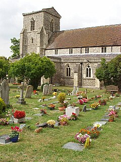
Pyrton is a small village and large civil parish in Oxfordshire about 1 mile (1.6 km) north of the small town of Watlington and 5 miles (8 km) south of Thame. The 2011 Census recorded the parish's population as 227. The toponym is from the Old English meaning "pear-tree farm".
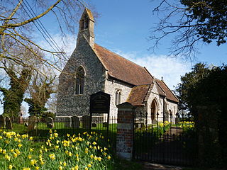
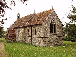
St Mary's Church is the Church of England parish church of Pyrton, Oxfordshire, England. Its parish is part of the benefice of Icknield, in the deanery of Aston and Cuddesdon, the archdeaconry of Oxford and the diocese of Oxford. The church is recorded in the National Heritage List for England as a designated Grade II* listed building.

Swyncombe is a hamlet and large civil parish in the high Chilterns, within the Area of Outstanding Natural Beauty about 4+1⁄2 miles (7 km) east of Wallingford, Oxfordshire, England. Swyncombe hamlet consists almost entirely of its Church of England parish church of Saint Botolph, the former rectory and Swyncombe House. The population of the parish is in the hamlets of Cookley Green and Russell's Water, and the scattered hamlet of Park Corner. The 2011 Census recorded the parish's population as 250. It is partially forested and is the fifth largest of 87 civil parishes in the District.

Stonor is a mostly cultivated and wooded village centred 3.8 miles (6.1 km) north of Henley-on-Thames in South Oxfordshire, England. It takes up part of the Stonor valley in the Chiltern Hills which rises to 120 meters above sea level within this south-east part of the civil parish. Stonor House close to the village centre has been the home of the Stonor family for more than eight centuries. The house and park are open to the public at certain times of the year. The house has a 12th-century private chapel built of flint and stone, with an early brick tower. There are also signs of a prehistoric stone circle in the park, which gives the place name its etymology.

John Chessell Buckler was a British architect, the eldest son of the architect John Buckler. J. C. Buckler initially worked with his father before taking over his practice. His work included restorations of country houses and at the University of Oxford.

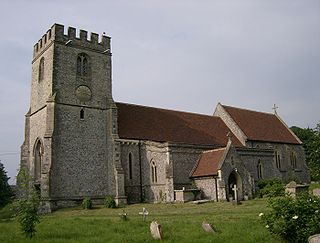
Shirburn is a village and civil parish about 6 miles (10 km) south of Thame in Oxfordshire. It contains the Grade I listed, 14th-century Shirburn Castle, along with its surrounding, Grade II listed park, and a parish church, the oldest part of which is from the Norman period. The parish has a high altitude by county standards. Its eastern part is in the Chiltern Hills Area of Outstanding Natural Beauty. Shirburn, the largest civil parish in the district, is forested to the south. A motorway cuts across one edge.

Sydenham is a village and civil parish about 3 miles (5 km) southeast of Thame in Oxfordshire. To the south the parish is bounded by the ancient Lower Icknield Way, and on its other sides largely by brooks that merge as Cuttle Brook, a tributary of the River Thame. The 2011 Census recorded the parish's population as 451.

Pishill with Stonor is a civil parish in the high Chilterns, South Oxfordshire. It includes the villages of Pishill and Stonor, and the hamlets of Maidensgrove and Russell's Water. Pishill with Stonor was formed by the merger of the separate civil parishes of Pishill and Stonor in 1922. In 2011 it had a human population of 304 across its 10.54km².
Highmoor is a village and civil parish in the Chiltern Hills in Oxfordshire, about 4 miles (6.4 km) west of Henley-on-Thames. The parish includes the hamlet of Satwell. The Grade II Listed Church of England parish church of Saint Paul at Highmoor Cross was designed by the architect Joseph Morris of Reading and built by Robert Owthwaite of Henley-on-Thames in 1859 as a chapel of ease by the vicar of Rotherfield Peppard to cater for the wider rural population of the parish. Highmoor later became a separate parish but the church was closed by a pastoral order in June 2012 as a result of a dwindling congregation. The church was then put up for sale by the Diocese of Oxford.
Crowell is a village and civil parish in Oxfordshire, about 4 miles (6.4 km) southeast of the market town of Thame and 1 mile (1.6 km) southwest of the village of Chinnor. The 2001 Census recorded the parish's population as 100. Crowell village is a spring line settlement at the source of a stream called the Pleck at the foot of the Chiltern Hills escarpment. The toponym "Crowell" is derived from the Old English for "crow's spring" or "crow's stream".
Watlington Park is an English country house with its surrounding grounds of approximately 500 acres (200 ha), located atop an escarpment in the Chiltern Hills, approximately 0.5 miles (0.80 km) southwest of Christmas Common and 1.4 miles (2.3 km) southeast of Watlington, Oxfordshire.


