
Wallingford is a historic market town and civil parish on the River Thames in South Oxfordshire, England, 12 miles (19 km) north of Reading, 13 miles (21 km) south of Oxford and 11 miles (18 km) north west of Henley-on-Thames. Although belonging to the historic county of Berkshire, it is within the ceremonial county of Oxfordshire for administrative purposes as a result of the 1972 Local Government Act. The population was 11,600 at the 2011 census.

South Oxfordshire is a local government district in the ceremonial county of Oxfordshire, England. Its council is temporarily based outside the district at Abingdon-on-Thames pending a planned move to Didcot, the district's largest town. The areas located south of the River Thames are within the historic county of Berkshire.
Stoke Gifford is a neighbourhood and parish and electoral ward in the South Gloucestershire district, in the ceremonial county of Gloucestershire, England. Formerly a separate village, it is now a suburb in the Bristol built-up area, part of the city's North Fringe. The ward had 14,200 residents in 5,788 households at the 2021 census and the parish had 19,794.

Crowmarsh Gifford, commonly known as Crowmarsh, is a village in the civil parish of Crowmarsh, in the South Oxfordshire district, in the county of Oxfordshire, England. It is beside the River Thames opposite the market town of Wallingford, the two linked by Wallingford Bridge. Crowmarsh parish also includes the hamlet of Newnham Murren, which is now merged with the village; the hamlet of Mongewell, and the village of North Stoke 2 miles (3.2 km) to the south.

Benson is a village and civil parish in South Oxfordshire, England. The 2011 Census gave the parish population as 4,754. It lies about a mile and a half north of Wallingford at the foot of the Chiltern Hills, where a chalk stream, Ewelme Brook, joins the River Thames next to Benson Lock.
Crowmarsh was a rural district in Oxfordshire, England from 1894 to 1932.
South Oxfordshire District Council, a non-metropolitan district council in Oxfordshire, England is elected every four years.

The A4130 is a British A road which runs from a junction with the A404 at Burchetts Green (Maidenhead), Berkshire to the A417 at Rowstock in Oxfordshire. It passes through Henley-on-Thames, and Nettlebed, and bypasses Wallingford and Didcot.

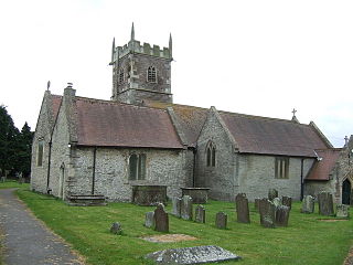
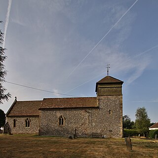
North Stoke is a small village beside the River Thames in the civil parish of Crowmarsh, in the South Oxfordshire district, in the county of Oxfordshire, England, 2 miles (3.2 km) south of the market town of Wallingford. Its 'Church of St Mary' is a Grade I listed building. In 1931 the parish had a population of 190. On 1 April 1932 the parish was abolished to form Crowmarsh.
Mongewell is a village in the civil parish of Crowmarsh in the South Oxfordshire district, in Oxfordshire, England, about 1 mile (1.6 km) south of Wallingford. Mongewell is on the east bank of the Thames, linked with the west bank at Winterbrook by Winterbrook Bridge. The earthwork Grim's Ditch, now part of The Ridgeway long-distance footpath, passes through the northern part of it and is a scheduled ancient monument. It has a church called St John the Baptist's Church.
Newnham Murren is a hamlet in the civil parish of Crowmarsh, in the South Oxfordshire district, in the county of Oxfordshire, England. It is in the Thames Valley, about 0.5 miles (800 m) east of the market town of Wallingford. Newnham Murren is now contiguous with the village of Crowmarsh Gifford. It has a church called St Mary's Church.
Langtree is an ancient hundred in the south-east of the county of Oxfordshire established during the Anglo-Saxon era. It was used to organize the local militia, apportion taxes and maintain roads. It was especially important in apprehending criminals and had a hundred court for local trials. Since the end of the nineteenth century its functions have been assumed by other divisions of government. It is currently dormant.
Nuffield is a village and civil parish in the Chiltern Hills in South Oxfordshire, England, just over 4 miles (6 km) east of Wallingford. The 2011 Census recorded the parish population as 939.

Stoke Row is a village and civil parish in the Chiltern Hills, about 5 miles (8 km) west of Henley-on-Thames in South Oxfordshire and about 9 miles (14 km) north of Reading. The 2011 Census recorded the parish population as 651.
Wallingford Rural District, an administrative area in what was then Berkshire, now Oxfordshire area, in southern England was established in 1894, from the then Berkshire area within Wallingford Rural Sanitary Authority. Wallingford Rural District Council provided many local government functions for the area around the town of Wallingford including Didcot, but not for the borough of Wallingford, which was covered by Wallingford Borough Council. These functions included dealing with contagious diseases, and wartime evacuations and air raid precautions. It also covered housing, water supply and sewage, and fire brigades.

St John the Baptist's Church is a closed, redundant Anglican church, partly in ruins, in what has thus reverted to the hamlet of Mongewell, Oxfordshire, England. It is recorded in the National Heritage List for England as a designated Grade II listed building, and is under the care of the Churches Conservation Trust. The ruins stand on the east bank of the River Thames, next to the former Carmel College, to the north of Mongewell Park, 2.5 miles (4 km) south of Wallingford, and near The Ridgeway long-distance path. Local Anglicans are in the parish of North Stoke: St Mary the Virgin.

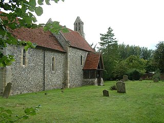
St Mary's Church is a redundant Anglican church in the hamlet of Newnham Murren, Oxfordshire, England. It is recorded in the National Heritage List for England as a designated Grade II* listed building, and is under the care of the Churches Conservation Trust. The church stands at the end of a farm track, overlooking the River Thames, near The Ridgeway long-distance path.

Vale of White Horse District Council is the local authority for the Vale of White Horse, a non-metropolitan district in the south-west of Oxfordshire, England.


