Related Research Articles
South Oxfordshire is a local government district in the ceremonial county of Oxfordshire, England. Its council is based in Milton Park, Milton. The areas located south of the River Thames are within the historic county of Berkshire.

West Oxfordshire is a local government district in northwest Oxfordshire, England, including towns such as Woodstock, Burford, Chipping Norton, Charlbury, Carterton and Witney, where the council is based.
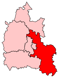
Henley is a constituency in Oxfordshire represented in the House of Commons of the UK Parliament since 2008 by John Howell, a member of the Conservative Party. He was elected in a by-election following the resignation of Boris Johnson, who had taken office as Mayor of London. The constituency was established for the 1885 general election.

Buckingham Rural District was a rural district in the administrative county of Buckinghamshire, England from 1894 to 1974, covering an area in the north-west of the county. It was named after but did not include the borough of Buckingham.

Banbury was a rural district in Oxfordshire, England from 1894 to 1974. It was formed under the Local Government Act 1894 from the bulk of the Banbury rural sanitary district, which had been divided among three counties. The Warwickshire part of the rural sanitary district formed the Farnborough Rural District, whilst the area in Northamptonshire formed the Middleton Cheney Rural District.
Ploughley was a rural district in Oxfordshire, England, from 1932 to 1974. It entirely surrounded Bicester but did not include it.
Wantage was a rural district of Berkshire, England from 1894 to 1974.
Long Crendon was a rural district in the administrative county of Buckinghamshire, England from 1894 to 1934.
Bullingdon Rural District was a rural district in Oxfordshire, England from 1932 to 1974, covering an area to the south-east of the city of Oxford.

Culham was a rural district in Oxfordshire, England from 1894 to 1932. It was formed under the Local Government Act 1894 from the part of the Abingdon Rural Sanitary District in the administrative county of Oxfordshire. The remainder of the sanitary district, in the administrative county of Berkshire, became Abingdon Rural District. The rural district council continued to be based at Abingdon, holding meetings in the workhouse of the poor law union.

Crowmarsh was a rural district in Oxfordshire, England from 1894 to 1932.

Hambleden Rural District was a rural district in Buckinghamshire, England from 1894 to 1934, covering an area in the south-west of the county.
Goring was a rural district in Oxfordshire, England from 1894 to 1932.
Bradfield was a rural district in Berkshire, England, from 1894 to 1974.
Abingdon was a rural district in the administrative county of Berkshire from 1894 to 1974.
St Helen Without is a civil parish in the Vale of White Horse district in the English county of Oxfordshire. In 1974 it was transferred from Berkshire. It is immediately west of Abingdon and includes the villages of Dry Sandford and Shippon. A large part of the parish is occupied by Dalton Barracks and its associated airfield. According to the 2001 census the parish had a population of 2,623. The parish was created by the Local Government Act 1894, by the division of the parish of Abingdon St. Helen. The part inside Abingdon Municipal Borough became part of Abingdon parish, whilst that part outside became St. Helen Without. It became part of the Abingdon Rural District of Berkshire in 1894, and then part of the Vale of White Horse in Oxfordshire under the Local Government Act 1972.
Abingdon was a municipal borough embracing the town of Abingdon-on-Thames in the county of Berkshire from 1835 to 1974. From 1894 it was nearly entirely surrounded by Abingdon Rural District. It was abolished in 1974 under the Local Government Act 1972, and merged with other districts to form the new Vale of White Horse district of Oxfordshire.
Faringdon was a rural district in the administrative county of Berkshire from 1894 to 1974.
Chipping Norton Rural District was a rural district in Oxfordshire, England from 1894 to 1974. It surrounded but did not include the town of Chipping Norton.
Witney Rural District was a rural district in Oxfordshire, England from 1894 to 1974. It surrounded but did not include the town of Witney.
References
- ↑ A Vision of Britain – Relationships / unit history of HENLEY RD Archived 1 October 2007 at the Wayback Machine
