Newington, Oxfordshire

Last updated

Newington
Newington StGiles SE.jpg
St Giles' parish church
Oxfordshire UK location map.svg
Red pog.svg
Newington
Location within Oxfordshire
Area7.28 km2 (2.81 sq mi)
Population102 (2011 Census)
  Density 14/km2 (36/sq mi)
OS grid reference SU5796
Civil parish
  • Newington
District
Shire county
Region
Country England
Sovereign state United Kingdom
Post town Wallingford
Postcode district OX10
Dialling code 01865
Police Thames Valley
Fire Oxfordshire
Ambulance South Central
UK Parliament
List of places
UK
England
Oxfordshire
51°39′50″N1°07′16″W / 51.664°N 1.121°W / 51.664; -1.121

Newington is a village and civil parish in South Oxfordshire, about 4+12 miles (7 km) north of Wallingford. The 2011 Census recorded the parish's population as 102. [1]

Contents

Archaeology

Archaeological work in the grounds of Newington House in the early 1980s and the latter half of the 2000s revealed extensive medieval occupation including at least one smithy. Some residual[ clarification needed ] ancient Roman pottery was recovered from medieval pits, indicating that there may have been a Roman farm or similar in the area. Newington is about 3 miles (5 km) from the Roman town of Dorchester on Thames.

The earliest in situ remains are evidence for plots from after the Norman conquest of England, indating from the late 11th and early 12th centuries. These may have been agricultural enclosures, such as paddocks, but were probably laid out as house-plots for tenants. By the early 12th century it seems that a smithy was built within one of the plots, followed in the 13th century by a larger smithy built on stone footings. This smithy was in use until the 14th century when it fell into disuse. Whether smithing was carried out elsewhere in Newington is still unknown, but by the 15th century the plot where the smithy formerly existed had been dug over and used for the disposal of rubbish. There is a 14th-century reference to Andrew le Smith from the attached hamlet of Brightwell; [2] probably Britwell Prior.

Manor

The Domesday Book valued Neutone (Newington) at £11 in the reign of King Edward the Confessor (1042–66) and £15 in 1086. [3] Early in the 11th century, a manor in the northern part of Berrick was joined to the parish of Newington.

[The manor] "fell into the hands of King Canute 'through forfeiture of a certain thegn'. It was begged of the King by his wife, Emma, and she passed it to the monks of Canterbury. This transaction swelled the parish of Newington which was a peculiar of the Archbishop of Canterbury". [4]

The manor came to be called Berrick Prior, meaning the corn farm belonging to the Prior of Canterbury. [5] As part of Newington, Berrick Prior "acquired an administrative status quite different from that of Berrick Salome, for even in the present [twentieth] century directories referred to it as 'the liberty of Berrick Prior' which reflected a sometime exemption from the jurisdiction of the Sheriff of Oxfordshire." [6] This status ended in 1993 when a local reorganisation of boundaries returned Berrick Prior to Berrick Salome parish.[ citation needed ] After the Parliament passed an Inclosure Act for lands in the liberties of Berrick Prior and Newington and Holcombe, an inclosure award was made on 30 March 1815. [7] The current Manor House was built about 1664, and a third storey and a Corinthian porch were added to it in about 1777. [8] The former Rectory, now Beauforest House, is a Georgian house of five bays built about 1774. [8] It is a Grade II* listed building. [9]

Newington Manor seen through its Grade II* listed wrought iron gates Newington Mansion - geograph.org.uk - 82870.jpg
Newington Manor seen through its Grade II* listed wrought iron gates

Parish church

The Church of England parish church of Saint Giles [11] was built in the 12th century, its transepts were added in about 1200 and the west tower and spire were added early in the 14th century. [12] The building is Grade I listed. [13] The tower has a ring of four bells. Roger Landen of Wokingham, Berkshire cast the second bell in about 1450. Robert Eldridge of Wokingham cast the treble bell in 1592. Henry I Knight of Reading, Berkshire cast the tenor bell in 1608. Abraham II Rudhall of Gloucester cast the third bell in 1719. For technical reasons the bells are currently unringable. St Giles' also has a Sanctus bell that Ellis I Knight of Reading cast in 1639. [14] Gilbert Sheldon held the living of the parish for a time in the 17th century. Sheldon also simultaneously held the livings of Hackney, Ickford, Buckinghamshire and Oddington, Oxfordshire. After the Restoration of the Monarchy, Sheldon was consecrated Archbishop of Canterbury in 1663.[ citation needed ]

Related Research Articles

<span class="mw-page-title-main">Ickford</span> Human settlement in England

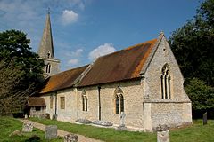
Ickford is a village and civil parish in the unitary authority area of Buckinghamshire, England. It is on the boundary with Oxfordshire, about 4 miles (6.4 km) west of the market town of Thame.

<span class="mw-page-title-main">Berrick Salome</span> Human settlement in England

Berrick Salome is a village and civil parish in South Oxfordshire, England, about 3 miles (5 km) north of Wallingford. Since the 1992 boundary changes, the parish has included the whole of Roke and Rokemarsh and Berrick Prior. The 2011 Census recorded the parish's population as 326. In 1965, Reginald Ernest Moreau (1897–1970), an eminent ornithologist, and a Berrick Salome resident from 1947, realized that he could build up a picture of the village as it had been in the decades before the First World War, based on the recollections of elderly villagers. His study, which was published in 1968 as The Departed Village: Berrick Salome at the Turn of the Century, also included an introduction to local history. This provided much of the information for "A Village History" which appeared in The Berrick and Roke Millennium Book and is the major source for this article.

<span class="mw-page-title-main">Asthall</span> Human settlement in England

Asthall or Asthal is a village and civil parish on the River Windrush in Oxfordshire, about 6 miles (10 km) west of Witney. It includes the hamlets of Asthall Leigh, Field Assarts, Stonelands, Worsham and part of Fordwells. The 2011 Census recorded the parish's population as 252. Asthall village is just south of the River Windrush, which also forms the south-eastern part of its boundary. The remainder of the parish including all of its hamlets lie north of the river. A minor road through Fordwells forms most of the parish's northern boundary. Most of the remainder of the parish's boundary is formed by field boundaries.

<span class="mw-page-title-main">Bletchingdon</span> Human settlement in England

Bletchingdon is a village and civil parish 2 miles (3 km) north of Kidlington and 6 miles (10 km) southwest of Bicester in Oxfordshire, England. Bletchingdon parish includes the hamlet of Enslow just over 1 mile (1.6 km) west of the village. The 2011 Census recorded the parish's population as 910.

<span class="mw-page-title-main">Broadwell, Oxfordshire</span> Human settlement in England

Broadwell is a village and civil parish about 2 miles (3 km) south-west of Carterton in West Oxfordshire. The 2011 Census recorded the parish's population as 218.

<span class="mw-page-title-main">Bucknell, Oxfordshire</span> Village in Oxfordshire, England

Bucknell is a village and civil parish 2+12 miles (4 km) northwest of Bicester in Oxfordshire, England. The 2011 Census recorded the parish's population as 260.

<span class="mw-page-title-main">Hampton Poyle</span> Human settlement in England

Hampton Poyle is a village in the civil parish of Hampton Gay and Poyle, in the Cherwell district, in the county of Oxfordshire, England. It is the Cherwell in valley, about 1 mile (1.6 km) northeast of Kidlington and about 5 miles (8 km) north of the centre of Oxford.

<span class="mw-page-title-main">Chalgrove</span> Human settlement in England

Chalgrove is a village and civil parish in South Oxfordshire about 10 miles (16 km) southeast of Oxford. The parish includes the hamlet of Rofford and the former parish of Warpsgrove with which it merged in 1932. The 2011 Census recorded the parish population as 2,830. Chalgrove is the site of a small Civil War battle in 1643, the Battle of Chalgrove Field. The Parliamentarian John Hampden was wounded in the battle, and died of his wounds six days later.

<span class="mw-page-title-main">Britwell Salome</span> Human settlement in England

Britwell Salome is a village and civil parish in South Oxfordshire, England centred 4+12 miles (7 km) northeast of Wallingford. The 2011 Census recorded the parish's population as 204.

<span class="mw-page-title-main">Drayton St. Leonard</span> Human settlement in England

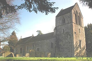
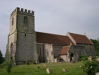
Drayton St. Leonard is a village and civil parish on the River Thame in Oxfordshire, about 8 miles (13 km) southeast of Oxford.

<span class="mw-page-title-main">Lewknor</span> Human settlement in England

Lewknor is a village and civil parish about 5 miles (8 km) south of Thame in Oxfordshire.The civil parish includes the villages of Postcombe and South Weston. The 2011 Census recorded the parish's population as 663.

<span class="mw-page-title-main">South Newington</span> Human settlement in England

South Newington is a village and civil parish on the south bank of the River Swere in the Cotswold Hills in Oxfordshire, England, about 5 miles (8 km) southwest of Banbury. The 2011 Census recorded the parish's population as 285.

<span class="mw-page-title-main">Wigginton, Oxfordshire</span> Human settlement in England

Wigginton is a village and civil parish about 6 miles (10 km) southwest of Banbury in Oxfordshire. The village is beside the River Swere, which forms the southern boundary of the parish. A Channel Four documentary, Hitler's British Girl, investigated the possibility that Unity Mitford gave birth to the son of Adolf Hitler in Hill View Cottage, Wigginton.

<span class="mw-page-title-main">Stratton Audley</span> Human settlement in England

Stratton Audley is a village and civil parish about 2.5 miles (4 km) northeast of Bicester in Oxfordshire, England.

<span class="mw-page-title-main">Marsh Baldon</span> Human settlement in England

Marsh Baldon is a village and civil parish about 5 miles (8 km) southeast of Oxford in Oxfordshire. Since 2012 it has been part of the Baldons joint parish council area, sharing a parish council with the adjacent civil parish of Toot Baldon. The 2011 Census population is 310.

<span class="mw-page-title-main">Hailey, Oxfordshire</span> Human settlement in England

Hailey is a village and civil parish about 2 miles (3 km) north of Witney, Oxfordshire. The village comprises three neighbourhoods: Middletown on the main road between Witney and Charlbury, Poffley End on the minor road to Ramsden and Delly End on Whiting's Lane. The parish extends from the River Windrush in the south, almost to the village of Ramsden and the hamlet of Wilcote in the north, and it includes the hamlet of New Yatt. The 2011 Census recorded the parish's population as 1,208.

<span class="mw-page-title-main">Sydenham, Oxfordshire</span> Human settlement in England

Sydenham is a village and civil parish about 3 miles (5 km) southeast of Thame in Oxfordshire. To the south the parish is bounded by the ancient Lower Icknield Way, and on its other sides largely by brooks that merge as Cuttle Brook, a tributary of the River Thame. The 2011 Census recorded the parish's population as 451.

<span class="mw-page-title-main">St Peter ad Vincula, South Newington</span> Church in Oxfordshire, England

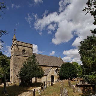
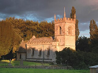
The Parish Church of Saint Peter ad Vincula, South Newington is the Church of England parish church of South Newington, a village about 5 miles (8 km) southwest of Banbury in Oxfordshire. The church is one of only 15 in England dedicated to St Peter ad Vincula, after the basilica of San Pietro in Vincoli in Rome.

<span class="mw-page-title-main">Steeple Barton</span> Human settlement in England

Steeple Barton is a civil parish and scattered settlement on the River Dorn in West Oxfordshire, about 8+12 miles (13.7 km) east of Chipping Norton, a similar distance west of Bicester and 9 miles (14 km) south of Banbury. Most of the parish's population lives in the village of Middle Barton, about 1 mile (1.6 km) northwest of the settlement of Steeple Barton. The 2011 Census recorded the parish's population as 1,523. Much of the parish's eastern boundary is formed by the former turnpike between Oxford and Banbury, now classified the A4260 road. The minor road between Middle Barton and Kiddington forms part of the western boundary. Field boundaries form most of the rest of the boundaries of the parish.

<span class="mw-page-title-main">Westcott Barton</span> Human settlement in England

Westcott Barton, also spelt Wescot Barton or Wescote Barton, is a village and civil parish on the River Dorn in West Oxfordshire about 7 miles (11 km) east of Chipping Norton and about 9+12 miles (15 km) south of Banbury, in the county of Oxfordshire, England. The parish is bounded to the north by Cockley Brook, a tributary of the River Dorn. A minor road to Kiddington forms part of the eastern boundary, another minor road forms part of the western boundary and the remainder of the parish boundaries are field boundaries. Westcott Barton's main area of housing is on the eastern boundary of the parish and contiguous with the village of Middle Barton in the neighbouring parish of Steeple Barton. The 2011 Census recorded the parish's population as 244.

References

  1. "Area: Newington (Parish): Key Figures for 2011 Census: Key Statistics". Neighbourhood Statistics . Office for National Statistics . Retrieved 18 August 2015.
  2. Ault 1972, p. 94.
  3. Salzman et al. 1939, pp. 396–428.
  4. Moreau 1968, p. 13.
  5. Moreau 1968, p. 14.
  6. Moreau 1968, pp. 13–14.
  7. "c cxiv", Act 50 Geo III, The National Archives, MPLL 1/2
  8. 1 2 Sherwood & Pevsner 1974, p. 716.
  9. Historic England. "Newington House (Grade II*) (1048070)". National Heritage List for England . Retrieved 18 August 2015.
  10. Historic England. "Entrance gates at Newington House Newington House (Grade II*) (1286245)". National Heritage List for England . Retrieved 18 August 2015.
  11. St Giles Church, Newington, Oxfordshire
  12. Sherwood & Pevsner 1974, p. 715.
  13. Historic England. "Church of St Giles (Grade I) (1193229)". National Heritage List for England . Retrieved 18 August 2015.
  14. Davies, Peter (16 December 2006). "Newington S Giles". Dove's Guide for Church Bell Ringers . Central Council for Church Bell Ringers . Retrieved 18 August 2015.

Sources

Commons-logo.svg Media related to Newington, Oxfordshire at Wikimedia Commons