
Elsfield is an English village and civil parish about 3 miles (5 km) northeast of the centre of Oxford. The village is 310 feet (94 m) above sea level on the western brow of a hill with relatively steep sides above the River Cherwell. For relative reference purposes, the Oxford alluvial flood plain is at 60 metres above sea level.

William Julius Mickle was a Scottish poet.

Shotover is a hill and forest in the civil parish of Forest Hill with Shotover, in the South Oxfordshire district, in the county of Oxfordshire, England. The hill is 3 miles (4.8 km) east of Oxford. Its highest point is 557 feet (170 m) above sea level.

Headington is an eastern suburb of Oxford, in the county of Oxfordshire, England. It is at the top of Headington Hill overlooking the city in the Thames valley below, and bordering Marston to the north-west, Cowley to the south, and Barton and Risinghurst to the east. The life of the large residential area is centred upon London Road, the main road between London and Oxford.
Wheatley is a village and civil parish in South Oxfordshire, England, about 5 miles (8 km) east of Oxford. The parish includes the hamlet of Littleworth, which is west of Wheatley.

Cuddesdon is a mainly rural village and former civil parish, now in the parish of Cuddesdon and Denton, in the South Oxfordshire district, in the county of Oxfordshire, England. centred 5.5 miles (9 km) ESE of Oxford. It has the largest Church of England clergy training centre, Ripon College Cuddesdon. Residents number approximately 430 in Cuddesdon's nucleated village centre and about 70 in the hamlets of Denton and Chippinghurst.
Bullingdon was a hundred in the county of Oxfordshire, covering an area to the east of Oxford. It took its name from the hamlet of Bullingdon Green, in the parish of Horspath, where the hundred court originally met.
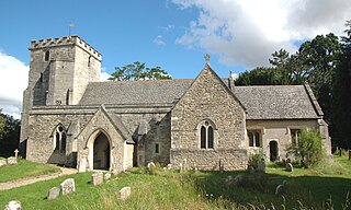
Horspath is a village and civil parish in South Oxfordshire about 3+1⁄2 miles (5.6 km) east of the centre of Oxford, England. The 2011 census recorded the parish's population as 1,378.

Stoke Talmage is a village and civil parish 4+1⁄2 miles (7 km) south of Thame in Oxfordshire. The 2001 Census recorded the parish population as 49. Because the parish population is below 100, the 2011 Census combined its figures with the output area for the civil parishes of Adwell and Shirburn.

Toot Baldon is a village and civil parish about 5 miles (8 km) southeast of Oxford in Oxfordshire. Since 2012 it has been part of the Baldons joint parish council area, sharing a parish council with the adjacent civil parish of Marsh Baldon. The 2011 Census recorded its population as 148.

Shirburn is a village and civil parish about 6 miles (10 km) south of Thame in Oxfordshire. It contains the Grade I listed, 14th-century Shirburn Castle, along with its surrounding, Grade II listed park, and a parish church, the oldest part of which is from the Norman period. The parish has a high altitude by county standards. Its eastern part is in the Chiltern Hills Area of Outstanding Natural Beauty. Shirburn, the largest civil parish in the district, is forested to the south. A motorway cuts across one edge.

Stanton St. John is a village and civil parish in Oxfordshire, England, about 4.5 miles (7 km) northeast of the centre of Oxford. The village is 330 feet (100 m) above sea level on the eastern brow of a group of hills northeast of Oxford, in a slight saddle between two of the hills.

Forest Hill is a village in the civil parish of Forest Hill with Shotover, in the South Oxfordshire district, in Oxfordshire, England, about 4.5 miles (7 km) east of Oxford. The village which is about 330 feet (100 m) above sea level is on the northeastern brow of a ridge of hills. The highest point of the ridge is Red Hill, which rises to 440 feet (130 m) just south of the village. The 2011 Census recorded Forest Hill with Shotover's population as 856.

Lyneham is a village and civil parish about 5 miles (8 km) southwest of Chipping Norton, Oxfordshire. It is bounded to the southwest by the River Evenlode, to the southeast by the A361 road linking Chipping Norton and Burford, and on other sides by field boundaries. The 2011 Census recorded the parish's population as 153.
Hampton Gay and Poyle is a civil parish in Oxfordshire, England. It was formed in 1932 by merger of the parishes of Hampton Gay and Hampton Poyle and as at 2011 had 141 residents across 6.11 km2

Shenington with Alkerton is a civil parish in the Cherwell district, in the county of Oxfordshire, England. It comprises the village of Shenington, which was an exclave of Gloucestershire until the Counties Act 1844 transferred it to Oxfordshire and the village of Alkerton, which was always part of Oxfordshire. It covers 9.60 km2 and as at the 2011 census had a population of 425 people.
Tiddington-with-Albury is a civil parish in the South Oxfordshire district, in the county of Oxfordshire. It includes the village of Albury, the larger village of Tiddington and the hamlet of Draycot. It was formed by a merger of the civil parishes of Albury and Tiddington in 1932 and in 2011 had a population of 660 across an area of 4.4 km².

Holton is a village and civil parish in South Oxfordshire about 5.5 miles (9 km) east of Oxford. The parish is bounded to the southeast by the River Thame, to the east and north by the Thame's tributary Holton Brook, to the south by London Road and to the west by field boundaries with the parishes of Forest Hill with Shotover and Stanton St John.

Juniper Hill is a hamlet in the civil parish of Cottisford in Oxfordshire, England, 2 miles (3.2 km) south of Brackley in neighbouring Northamptonshire.
Tiddington is a village in the civil parish of Tiddington-with-Albury, in the South Oxfordshire district, in Oxfordshire, England. It is about 3+1⁄2 miles (5.6 km) west of Thame, on the A418 road between Thame and Oxford. The 2011 Census recorded Tiddington-with-Albury's population as 683. Tiddington is on the county boundary with Buckinghamshire. It was a manor and hamlet of the parish of Albury, although for most of its history it has been a larger place than Albury. In 1866 Tiddington became a separate civil parish, on 1 April 1932 the parish was merged with Albury to form "Tiddington with Albury". In 1931 the parish had a population of 163.

