
Oxfordshire is a ceremonial county in South East England. The county is bordered by Northamptonshire and Warwickshire to the north, Buckinghamshire to the east, Berkshire to the south, and Wiltshire and Gloucestershire to the west. The city of Oxford is the largest settlement and county town.

South Oxfordshire is a local government district in the ceremonial county of Oxfordshire, England. Its council is temporarily based outside the district at Abingdon-on-Thames pending a planned move to Didcot, the district's largest town. The areas located south of the River Thames are within the historic county of Berkshire.
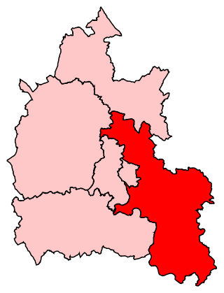
Henley was a constituency in Oxfordshire represented in the House of Commons of the UK Parliament from the 2008 to 2024 by John Howell, a Member of Parliament from the Conservative Party.
Aylesbury was a rural district in the administrative county of Buckinghamshire, England from 1894 to 1974. It was named after but did not include Aylesbury, which was a separate municipal borough.

Crowmarsh Gifford, commonly known as Crowmarsh, is a village in the civil parish of Crowmarsh, in the South Oxfordshire district, in the county of Oxfordshire, England. It is beside the River Thames opposite the market town of Wallingford, the two linked by Wallingford Bridge. Crowmarsh parish also includes the hamlet of Newnham Murren, which is now merged with the village; the hamlet of Mongewell, and the village of North Stoke 2 miles (3.2 km) to the south.
Henley was a rural district in Oxfordshire, England from 1894 to 1974.
Long Crendon was a rural district in the administrative county of Buckinghamshire, England from 1894 to 1934.
Bullingdon Rural District was a rural district in Oxfordshire, England from 1932 to 1974, covering an area to the south-east of the city of Oxford.
Culham was a rural district in Oxfordshire, England, from 1894 to 1932. It was formed under the Local Government Act 1894 from the part of the Abingdon Rural Sanitary District in the administrative county of Oxfordshire. The remainder of the sanitary district, in the administrative county of Berkshire, became Abingdon Rural District. The rural district council continued to be based at Abingdon, holding meetings in the workhouse of the poor law union.
Headington was a rural district in Oxfordshire, England from 1894 to 1932, based on the Headington rural sanitary district. It covered an area to the east of the city of Oxford. The parish of Headington was split out as a separate urban district in 1927.

Hambleden Rural District was a rural district in Buckinghamshire, England from 1894 to 1934, covering an area in the south-west of the county.
Goring was a rural district in Oxfordshire, England from 1894 to 1932.

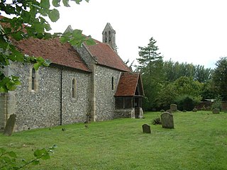
North Stoke is a small village beside the River Thames in the civil parish of Crowmarsh, in the South Oxfordshire district, in the county of Oxfordshire, England, 2 miles (3.2 km) south of the market town of Wallingford. Its 'Church of St Mary' is a Grade I listed building. In 1931 the parish had a population of 190. On 1 April 1932 the parish was abolished to form Crowmarsh.
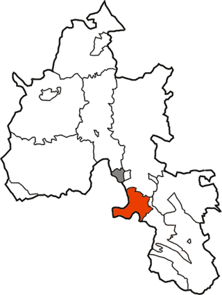
Crowmarsh is a fairly large, mostly rural civil parish in the South Oxfordshire, district, in the county of Oxfordshire, England, east and southeast of the town of Wallingford on the opposite bank of the River Thames and may also refer to its larger district council ward which extends to Ipsden and Nuffield. In 2011 it had a population of 2830.
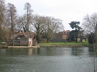
Mongewell is a village in the civil parish of Crowmarsh in the South Oxfordshire district, in Oxfordshire, England, about 1 mile (1.6 km) south of Wallingford. Mongewell is on the east bank of the Thames, linked with the west bank at Winterbrook by Winterbrook Bridge. The earthwork Grim's Ditch, now part of The Ridgeway long-distance footpath, passes through the northern part of it and is a scheduled ancient monument. It has a church called St John the Baptist's Church.
Newnham Murren is a hamlet in the civil parish of Crowmarsh, in the South Oxfordshire district, in the county of Oxfordshire, England. It is in the Thames Valley, about 0.5 miles (800 m) east of the market town of Wallingford. Newnham Murren is now contiguous with the village of Crowmarsh Gifford. It has a church called St Mary's Church.
Barton Regis was, from 1894 to 1904, a rural district in the English administrative county of Gloucestershire, adjacent to the City of Bristol.
Wallingford Rural District, an administrative area in what was then Berkshire, now Oxfordshire area, in southern England was established in 1894, from the then Berkshire area within Wallingford Rural Sanitary Authority. Wallingford Rural District Council provided many local government functions for the area around the town of Wallingford including Didcot, but not for the borough of Wallingford, which was covered by Wallingford Borough Council. These functions included dealing with contagious diseases, and wartime evacuations and air raid precautions. It also covered housing, water supply and sewage, and fire brigades.
Chipping Norton Rural District was a rural district in Oxfordshire, England from 1894 to 1974. It surrounded but did not include the town of Chipping Norton.
Witney Rural District was a rural district in Oxfordshire, England from 1894 to 1974. It surrounded but did not include the town of Witney.

