Remains of what is believed to be a Roman temple have been discovered on the north side of the village at High Wood.[2][3] Binfield Heath takes its name from the Saxon hundred of Binfield to which it belonged, along with much of the locality. The name Binfield itself derives from Benifeld, noted in 1176 with later variant spellings, and may come from an original Beonan field, ‘a field belonging to Beona'. Because of the poor quality of land in this area it was left as heath, roughly in the centre of what is now the village. The heath was originally common land, lying between what is now Dunsden Way, Gravel Road, Emmer Green Road and Common Lane. The heath had four gates leading onto it, one each at the Bottle & Glass, the New Inn, The Coach and Horses and Coppid Cross Roads. Local inhabitants had the right to pasture their animals on it. Shiplake Row, leading down from Binfield Heath towards Shiplake Cross, was among the earliest roads to be populated.[4]
Until 2003, half of Binfield Heath and the hamlet of Crowsley were the western part of the civil parish of Shiplake with the rest in the parish of Eye & Dunsden. This almost exactly rectangular tract of land acquired its own civil parish in 2003. Having some other amenities, Binfield Heath meets the criteria of a village— omitting the old criterion of an Anglican place of worship to give the contemporary definition of a village. The central community is green buffered but not isolated, as it is a relatively small knoll in the foothills of the Chiltern Hills: Dunsden church is 1⁄2 mile (800m) south-west and both communities are combined with the ecclesiastical parish today of Shiplake.[5] A house on Arch Hill was used as headquarters for an illegal global drug operation until it was raided in 1977 under Operation Julie, as recounted by Leaf Fielding in the book To live outside the law.[6]
The village has revived the tradition of the annual 'wheelbarrow race', which used to run in the seventies and eighties between the Bottle and Glass Inn on Bones Lane and the White Hart at Shiplake Row (now Orwells restaurant), a distance of 1.2 miles. Pairs competed in fancy dress, with one entrant riding and the other pushing. Both would down a pint of beer at the start before charging down Common Lane towards Arch Hill and the village stores; when they reached the halfway point at the New Inn (since closed), they would down another beer before swapping roles and making for the finish at the White Hart where a final pint awaited them. The event was held on public roads and discontinued in 1991.[7] After a hiatus of nearly 30 years, the event took place on the village recreation ground on 9 June 2019.[8] The village has for the past 70 years held a Dog and Flower show which takes place on the field opposite Holmwood House
Geography
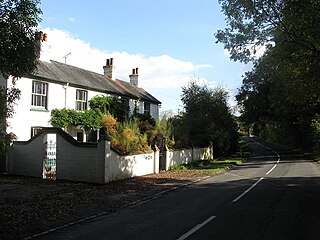
Two cottages in the southwest of Binfield Heath near the main area of woodland, which forms part of the background
Binfield Heath has an almost continuous street of Victorian houses, Shiplake Row, which leads 1⁄2 mile (800m) and descends 25 metres to the larger village of Shiplake by the River Thames. Crowsley Park Wood is the parish's largest woodland and is the opposite side of the village from the combined 'Comp Wood, The Common and Oakhouse Wood' and the field-surrounded Kings Common woodland.
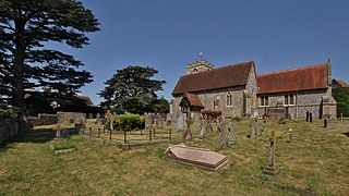
Landmarks
Crowsley Park House20th century homes around a green junction on the edge of the village.
The Crowsley Park estate, including a Grade II listed, 18th century mansion house, a grotto, barns and a stable, is west of the village centre which has the vast majority of buildings in the village. In the heart of the village and to the west and south are 11 other homes, also listed: Jasmine Cottage, Freize Farmhouse, The Well House, Fir Tree Cottage, Thatched Cottage, Shiplake Rise Cottage, The Bottle and Glass, The Old House, Coppice Cottage, Elm Tree Farmhouse, Hampstead Farm Stable, and seven barns.[9] Keeps Well, a covered well by Holmwood house was accidentally demolished by a tractor driver in the 1990s, but has subsequently been rebuilt.
Holmwood, an 18th-century country house, is located on Shiplake Row in Binfield Heath, set over 26.6 acres of grounds. It was owned by Admiral Charles Swinburne in the 19th-century and was the family home of Swinburne's son, the poet Algernon Swinburne.[10] For many years Holmwood was owned by the Makower family.[11] It was owned by the barrister and peer Jonathan Marks, Baron Marks of Henley-on-Thames from 2008 to 2018 and restored by him.[10] Holmwood was bought by Rupert Murdoch and Jerry Hall for £11 million in 2019.[12] Murdoch and Hall divorced in 2022 with Hall keeping Holmwood in the divorce settlement.[13]
There used to be two brick kilns on the east end of Kiln Lane; the first dates back to 1817 and closed between 1903 and 1907, the other kiln closed in 1935. At the west end of Kiln Lane are some timber houses, donated by Sweden at the end of the Second World War to ease the housing shortage. The village smithy, which stands next to the chestnut tree in the centre of the village, is now The Forge Garage.[14] The village still has a local post office and village store which serves the every growing community
Christian Bale, actor, lived on Gravel Road and attended nearby Shiplake Primary School.
Robert Hardy, actor, lived in Binfield Heath near High Wood. The house sported a weather vane showing an archer, after the actor's passion for archery.
Rupert Murdoch, businessman, and his then wife Jerry Hall purchased Holmwood, an 18th-century house and estate in the village.[21]
Tom Rowlands, musician with electronic duo The Chemical Brothers grew up in the village and attended Shiplake Primary School.
Demography
The population rose by 9.6% in the ten years to 2011 (from 643 in 2001 to 709). Binfield Heathians are known as 'fuzz-croppers', as distinct from the nearby Shiplake 'water rats'.
Henley-on-Thames is a town and civil parish on the River Thames, in the South Oxfordshire district, in Oxfordshire, England, 9 miles (14 km) northeast of Reading, 7 miles (11 km) west of Maidenhead, 23 miles (37 km) southeast of Oxford and 37 miles (60 km) west of London, near the tripoint of Oxfordshire, Berkshire and Buckinghamshire. The population at the 2021 Census was 12,186.
Shiplake consists of three settlements: Shiplake, Shiplake Cross and Lower Shiplake. Together these villages form a civil parish situated beside the River Thames 2 miles (3 km) south of Henley-on-Thames, Oxfordshire, England. The river forms the parish boundary to the east and south, and also the county boundary between Oxfordshire and Berkshire. The villages have two discrete centres separated by agricultural land. The 2011 Census records the parish population as 1,954 and containing 679 homes. The A4155 main road linking Henley with Reading, Berkshire passes through the parish.
Nettlebed is a village and civil parish in Oxfordshire in the Chiltern Hills about 4+1⁄2 miles (7 km) north-west of Henley-on-Thames and 6 miles (10 km) south-east of Wallingford. The parish includes the hamlet of Crocker End, about 1⁄2 mile (800 m) east of the village. The 2011 Census recorded a parish population of 727.
Pishill is a village and former civil parish, now in the parish of Pishill with Stonor, in the South Oxfordshire district, in the county of Oxfordshire, England. It is about 5 miles (8 km) north of Henley-on-Thames, in the Stonor valley in the Chiltern Hills about 430 feet (130 m) above sea level. In 1921 the parish had a population of 147.
Wivelsfield village and the larger adjacent village of Wivelsfield Green are the core of the civil parish of Wivelsfield in the Lewes District of East Sussex, England. The villages are 9.3 miles (15.0 km) north of the city of Brighton and Hove.
Bix is a village in the civil parish of Bix and Assendon in South Oxfordshire, about 2.5 miles (4 km) northwest of Henley-on-Thames. The village is about 130 metres (430 ft) above sea level in the Chiltern Hills.
Mapledurham is a small village, civil parish and country estate beside the River Thames in southern Oxfordshire, England. The large parish borders Caversham, the most affluent major district of Reading, Berkshire. Historic buildings in the area include the Church of England parish church of St. Margaret, Mapledurham Watermill and Mapledurham House.
Nuneham Courtenay is a village and civil parish about 5 miles (8 km) SSE of Oxford. It occupies several miles close to the east bank of the River Thames.
Sonning Common is a village and civil parish in a relatively flat, former common land part of the Chiltern Hills in South Oxfordshire, centred 3.5 miles (6 km) west south-west of Henley-on-Thames and 2.5 miles (4 km) north of Reading.
Harpsden is a rural and semi-rural village and civil parish immediately south of Henley-on-Thames in South Oxfordshire, Oxfordshire, England. Its scattered centre is set 0.5 miles (0.80 km) from the east border which is the River Thames, marking a short boundary with Berkshire. The parish extends 5 miles (8.0 km) inland and borders Rotherfield Peppard to the west, that is, next to its main sections of woodland in the southern extreme of the Chiltern Hills including an SSSI area of ancient woodland. The village has neither a railway station nor shops, but has the main road from Reading to Henley, both of which have grown substantially since World War II into centres of trade, education and general meeting places, such as by their increased number of cafés and restaurants.
Eye and Dunsden is a largely rural civil parish in the most southern part of the English county of Oxfordshire. It includes the villages of Sonning Eye, Dunsden Green and Playhatch and borders on the River Thames with the village of Sonning in Berkshire connected via multi-span medieval Sonning Bridge. Before 1866, Eye & Dunsden was part of the trans-county parish of Sonning.
Chazey Heath is a hamlet in Oxfordshire, England, about 3 miles (4.8 km) north of Reading, Berkshire. It is situated on the A4074 road, between Caversham and Oxford, at its junction with the rural road to Goring Heath and Goring-on-Thames. For local government purposes Chazey Heath is in Mapledurham civil parish, which forms part of the district of South Oxfordshire within the county of Oxfordshire. It is within the Henley constituency of the United Kingdom Parliament. Prior to Brexit in 2020, it was represented by the South East England constituency for the European Parliament.
Polstead is a village and civil parish in the Babergh district of Suffolk, England. The village lies 3 miles (4.8 km) northeast of Nayland, 5 miles (8 km) southwest of Hadleigh and 9 miles (14 km) north of Colchester. It is situated on a small tributary stream of the River Stour. In 2011 the parish had a population of 851.
South Holmwood is a semi-rural village in Surrey, England. It can be considered cognate with its wider civil parish, which stretches to the east to embrace Holmwood Common, but does not include Mid Holmwood, or North Holmwood, the latter being contiguous with Dorking. Betchett's Brook is the southern boundary and runs through a locality known as Holmwood Corner. However, Holmwood railway station is within the parish of Capel, although connected to the South Holmwood by a curved path passing through Holmwood Corner Common. Centred 3 miles (4.8 km) south of Dorking, South Holmwood is on the A24 London to Worthing road, a dual carriageway through the village.
Stoke Row is a village and civil parish in the Chiltern Hills, about 5 miles (8 km) west of Henley-on-Thames in South Oxfordshire and about 9 miles (14 km) north of Reading. The 2011 Census recorded the parish population as 651.
Exlade Street is a hamlet in Checkendon civil parish in Oxfordshire, about 6 miles (9.7 km) northwest of Reading, in the Chiltern Hills. The hamlet is about 445 feet (136 m) above sea level.
Jonathan Clive Marks, Baron Marks of Henley-on-Thames, is a British barrister and Liberal Democrat life peer in the House of Lords.
Sparsholt is a village and civil parish about 3 miles (5 km) west of Wantage in the Vale of White Horse district of Oxfordshire. The parish includes the hamlet of Westcot about 1⁄2 mile (800 m) west of the village. Sparsholt was part of Berkshire until the 1974 boundary changes transferred the Vale of White Horse to Oxfordshire.
Crowsley Park is a 160-acre (65 ha) country estate in South Oxfordshire, central-southern England, owned by the British Broadcasting Corporation (BBC).
Holmwood is a country house in the village of Binfield Heath in Oxfordshire, England.
This page is based on this Wikipedia article Text is available under the CC BY-SA 4.0 license; additional terms may apply. Images, videos and audio are available under their respective licenses.