Vale of White Horse

Last updated

Vale of White Horse
Vale of White Horse District
Ginge.jpg
Characteristic landscape of farmland, hills and woodlands
Vale of White Horse UK locator map.svg
Vale of White Horse shown within Oxfordshire
Sovereign state United Kingdom
Constituent country England
Region South East England
Non-metropolitan county Oxfordshire
Historic county Berkshire
Status Non-metropolitan district
Admin HQ Milton, Vale of White Horse
Incorporated1 April 1974;49 years ago (1 April 1974)
Government
  TypeNon-metropolitan district council
  Body Vale of White Horse District Council
  Executive Liberal Democrat
   MPs Layla Moran (Liberal Democrat)
David Johnston (Conservative)
Area
  Total223.4 sq mi (578.6 km2)
  Rank65th (of 296)
Population
 (2021)
  Total139,487
  Rank164th (of 296)
  Density620/sq mi (240/km2)
  Ethnicity [1]
95.6% White
1.4% S.Asian
1.2% Chinese or other
1.1% Mixed Race
0.7% Black British
Time zone UTC0 (GMT)
  Summer (DST) UTC+1 (BST)
ONS code 38UE (ONS)
E07000180 (GSS)
OS grid reference SU3462689188
Website www.whitehorsedc.gov.uk

The Vale of White Horse is a local government district of Oxfordshire in England. It was historically a north-west projection of Berkshire. The area is commonly referred to as the 'Vale of the White Horse'. It is crossed by the Ridgeway National Trail in its far south, across the North Wessex Downs AONB at the junction of four counties. The northern boundary is defined by the River Thames. The name refers to Uffington White Horse, a prehistoric hill figure.

Contents

As well as being a local authority district, the Vale of White Horse is a geographical, historical and cultural region. The name "Vale of White Horse" predates the present-day local authority district, having been described, for example, in Daniel Defoe's 1748 travel account A Tour thro' the Whole Island of Great Britain . [2] There are references to the name as early as the 17th century; the Elizabethan antiquarian and historian William Camden referred to the "Vale of White Horse" in his 1610 topographical study on the British Isles. [3] Traditionally, the Vale has been understood to cover an area wider than the present-day local authority district, stretching from Buscot, in the west, to Streatley, in the east. [4] The Vale and Downland Museum, based in Wantage, stores and presents the cultural heritage of the region.

History

The area has been long settled as a productive fertile chalklands above well-drained clay valleys, and well-farmed with many small woodlands and hills between the Berkshire Downs and the River Thames on its north and east sides. It is named after the prominent and large Bronze Age-founded Uffington White Horse hill figure.

The local government district was formed as part of the 1974 re-organisation, taking in three small Berkshire towns – in descending size order Abingdon, Faringdon and Wantage – and the surrounding rural parishes. There are 68 parishes in the district. Previously, since the 19th century, the administrative areas had been the Municipal Borough of Abingdon, Wantage Urban District, Abingdon Rural District, Faringdon Rural District, and most of Wantage Rural District.

Politics

The Vale of White Horse District Council is based in Milton Park, Milton. The council has been controlled by either Liberal Democrat or Conservative administrations since Vale of White Horse was created in 1973. The council was run by the Conservative Party from 2011 until the 2019 UK local elections, at which the Liberal Democrats regained control in a landslide, after having previously held the council from 1995 to 2011. [5]

Geography

The Vale is the valley of the Ock, a stream which joins the Thames from the west at Abingdon. It is almost flat and well wooded, its green meadows and foliage contrasting richly with the bald summits of the Berkshire Downs, which flank it on the south. The numerous elm trees that once were a major feature of the Vale were lost to Dutch Elm Disease. To the north, a low ridge separates it from the upper Thames Valley, holding back the soft Jurassic sedimentary and Cretaceous deposits (Greensand, Gault and Kimmeridge Clay) behind a hard corallian limestone escarpment ridge, in what is technically a hanging valley; but local usage sometimes extends the vale to cover all the ground between the Cotswolds (on the north) and the Berkshire Downs. According to the geographical definition, however, the Vale is from two to five miles wide, and the distance by road from Abingdon to Shrivenham at its head is 18 miles.

Wantage is the only town in the foot or slopes of the vale (Faringdon, on the northwestern rim, is closely associated). Wantage is in a sheltered hollow at the foot of the hills, along which villages concentrate often in long strip parishes. Numerous springs, the run-off from the chalk hills were main local water sources, and an accessible water table enabled the growing of fruits, grains and vegetables.

Sites of interest

White Horse Hill

Towards the west, above Uffington, the hills reach a culminating point of 261 m (856 ft) in White Horse Hill. In its northern flank, just below the summit, a gigantic figure of a horse is cut, consisting of deep trenches filled with crushed white chalk. This figure gives name to the hill, the range and the Vale. It is 114 m (374 ft) long and highly stylised, the neck, body and tail varying little in width.

A panoramic view into the Vale; the White Horse is on the right and Dragon Hill centre right Dragon Hill 20040424.jpg
A panoramic view into the Vale; the White Horse is on the right and Dragon Hill centre right

The origin of the figure is unknown. Tradition asserted it to be the monument of a victory over the Danes by King Alfred, who was born at Wantage, but the site of the Battle of Ashdown (871 CE), has been variously located. Moreover, the figure has been dated to the Bronze Age, so it pre-dates the battle by many centuries. Many ancient remains occur in the vicinity of the Horse.

Vale scene, with White Horse Hill on the horizon Vale of White Horse c.jpg
Vale scene, with White Horse Hill on the horizon
The Uffington White Horse, as seen from an altitude of about 600 m (2000 ft), from the cockpit of a glider White horse from air.jpg
The Uffington White Horse, as seen from an altitude of about 600 m (2000 ft), from the cockpit of a glider

On the summit of the hill there is an extensive and well-preserved circular camp, apparently used by the Romans but of much earlier origin. It is an Iron Age hill fort named Uffington Castle, after the village in the vale below. Within a short distance are Hardwell Castle, a near-square work and, on the southern slope of the hills near Ashdown House, a small camp traditionally called Alfred's Castle. Further to the West, there is Liddington Castle.

A smooth, steep gully on the north flank of White Horse Hill is called the Manger, and to the west of it rises a bald mound named Dragon Hill, the traditional scene of St George's victory over the dragon, the blood of which made the ground bare of grass for ever. But the name may derive from Celtic Pendragon ("dragon's head"), which was a title for a king, and may point to an early place of burial.

The Vale as a whole appears at the beginning of Tom Brown's Schooldays , as the scene of innocent Saxon boyhood adventures, before the eponymous hero is sent away to school at Rugby. Rosemary Sutcliff's 1977 historical novel Sun Horse, Moon Horse takes place in the Vale, telling the tale of the White Horse's creation in ancient Celtic times.

Waylands Smithy

To the west of White Horse Hill lies a long barrow called Wayland's Smithy, said to be the home of a smith who was never seen, but who shod the horses of travellers if they were left at the place with payment. The legend is elaborated, and the smith appears as a character, in Sir Walter Scott's novel Kenilworth , and in Rudyard Kipling's Puck of Pook's Hill .

The Ridgeway

A grassy track represents the Ridgeway, claimed as the oldest road in Europe, perhaps five thousand years old or more. It travels along the crest of the hills, far above what would then have been marshy lowlands or forests, continuing Icknield Street, from the Chilterns to Goring and Streatley on the River Thames. It links The Wash and Salisbury Plain, and would have been an important artery for trade.

Other earthworks, in addition to those near the White Horse, overlook the Vale, such as Letcombe Castle (also known as Segsbury Camp) above Wantage. At the foot of the hills, not far east of the Horse, is preserved the so-called Blowing Stone of Kingston Lisle, a mass of sandstone (a sarsen) pierced with holes in such a way that, when blown like a trumpet, it produces a loud note. It is believed that, in earlier times, the stone served the purpose of a bugle.

Several of the village churches in the Vale are of interest, notably the fine Early English cruciform building at Uffington, that has an octagonal tower and is known as The Cathedral of the Vale. [6]

Economy

Farmland and White Horse Hill Vale scenery.JPG
Farmland and White Horse Hill

Farming is mostly arable. In livestock the range is mixed. The area had a large dairy industry, especially in the 1960s, but it was much reduced by the 21st century, with the large fertile fields supported by subsidies. The Lockinge Estate is a longstanding agricultural employer within the region.

Natural mineral resources are mined (quarried) in the Vale. These include sand, gravel and (formerly) Fuller's Earth.

With the closure of British Leyland's long-established MG works at Abingdon in 1980, [7] there is no motor industry, apart from some specialist car makers and component factories. Macdermid Autotype in Wantage remains one of the few large industrial employers in the region.

The length of the Vale is traversed by the Great Western Main Line and the Cherwell Valley Line. Appleford railway station and Radley railway station are now the only stations within the Vale, although there used to be stations at Challow, Uffington, Grove (near Wantage), Abingdon and Steventon. These all closed as part of the Beeching cuts, in the early 1960s. The nearest mainline stations are now Swindon, Oxford and Didcot Parkway.

The Harwell Science and Innovation Campus is a large employer, particularly for scientists and engineers.

At one time Amey plc had its head office in Sutton Courtenay, Vale of White Horse. [8]

See also

Notes

  1. "Resident Population Estimates by Ethnic Group, Vale of White Horse". Office for National Statistics. Archived from the original on 12 June 2011. Retrieved 28 June 2008.
  2. "A Tour thro' the Whole Island of Great Britain (1748)". Google Books. Retrieved 31 May 2023.
  3. "Berkshire, Surrey and Sussex". A vision of Britain though time. Retrieved 7 February 2023.
  4. "General view of the agriculture of Berkshire. Drawn up for the consideration of the Board of Agriculture and internal improvement (1809)". Google Books. Retrieved 8 February 2023.
  5. "Election results: Lib Dems win Oxfordshire Tory council". BBC News. 3 May 2019. Retrieved 3 May 2019.
  6. Nash Ford, David. "Uffington: St. Mary's Church". Berkshire History. Retrieved 9 February 2016.
  7. Webb, Clifford (24 October 1980). "The MG factory at Abingdon closes today". Honest John. Retrieved 4 June 2018.
  8. "Amey bids for high-flying firm". Oxford Mail. 22 January 1999. Retrieved 9 February 2016.

Related Research Articles

<span class="mw-page-title-main">The Ridgeway</span> Ancient trackway described as Britains oldest road

The Ridgeway is a ridgeway or ancient trackway described as Britain's oldest road. The section clearly identified as an ancient trackway extends from Wiltshire along the chalk ridge of the Berkshire Downs to the River Thames at the Goring Gap, part of the Icknield Way which ran, not always on the ridge, from Salisbury Plain to East Anglia. The route was adapted and extended as a National Trail, created in 1972. The Ridgeway National Trail follows the ancient Ridgeway from Overton Hill, near Avebury, to Streatley, then follows footpaths and parts of the ancient Icknield Way through the Chiltern Hills to Ivinghoe Beacon in Buckinghamshire. The National Trail is 87 miles (140 km) long.

<span class="mw-page-title-main">Oxfordshire</span> County of England

Oxfordshire is a ceremonial county in South East England. The county is bordered by Northamptonshire and Warwickshire to the north, Buckinghamshire to the east, Berkshire to the south, and Wiltshire and Gloucestershire to the west. The city of Oxford is the largest settlement and county town.

<span class="mw-page-title-main">Berkshire</span> County of England

The Royal County of Berkshire, more commonly known as simply Berkshire, is a ceremonial county in South East England. It is bordered by Oxfordshire to the north and the north-west, Buckinghamshire to the north-east, Greater London to the east, Surrey to the southeast, Hampshire to the south and the south-west, and Wiltshire to the west. Reading is the largest settlement and the county town.

<span class="mw-page-title-main">Uffington White Horse</span> Prehistoric carving in Uffington, England

The Uffington White Horse is a prehistoric hill figure, 110 m (360 ft) long, formed from deep trenches filled with crushed white chalk. The figure is situated on the upper slopes of Whitehorse Hill in the English civil parish of Uffington, some 16 km (10 mi) east of Swindon, 8 km (5.0 mi) south of the town of Faringdon and a similar distance west of the town of Wantage; or 2.5 km (1.6 mi) south of Uffington. The hill forms a part of the scarp of the Berkshire Downs and overlooks the Vale of White Horse to the north. The best views of the figure are obtained from the air, or from directly across the Vale, particularly around the villages of Great Coxwell, Longcot, and Fernham.

<span class="mw-page-title-main">Wantage</span> Human settlement in England

Wantage is a historic market town and civil parish in Oxfordshire, England. Although within the boundaries of the historic county of Berkshire, it has been administered as part of the Vale of White Horse district of Oxfordshire since 1974. The town is on Letcombe Brook, 8 miles (13 km) south-west of Abingdon, 24 miles (39 km) north-west of Reading, 15 miles (24 km) south-west of Oxford and 14 miles (23 km) north-west of Newbury.

<span class="mw-page-title-main">Faringdon</span> Market town in Oxfordshire, England

Faringdon is a historic market town in the Vale of White Horse, Oxfordshire, England, 18 miles (29 km) south-west of Oxford, 10 miles (16 km) north-west of Wantage and 12 miles (19 km) east-north-east of Swindon. It extends to the River Thames in the north; the highest ground is on the Ridgeway in the south. Faringdon was Berkshire's westernmost town until the 1974 boundary changes transferred its administration to Oxfordshire. The civil parish is formally known as Great Faringdon, to distinguish it from Little Faringdon in West Oxfordshire. The 2011 Census gave a population of 7,121; it was estimated at 7,992 in 2019. On 1 February 2004, Faringdon became the first place in south-east England to be awarded Fairtrade Town status.

<span class="mw-page-title-main">Streatley, Berkshire</span> Thames-side village, Berkshire, England

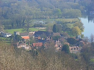
Streatley is a village and civil parish on the River Thames in Berkshire, England. The village faces Goring-on-Thames. The two places share in their shops, services, leisure, sports and much of their transport. Across the river is Goring & Streatley railway station and the village cluster adjoins a lock and weir. The west of the village is a mixture of agriculture and woodland plus a golf course. The village has a riverside hotel. Much of Streatley is at steeply varying elevations, ranging from 51m AOD to 185m at Streatley Warren, a hilltop point on its western border forming the eastern end of the Berkshire Downs. This Area of Outstanding Natural Beauty is topped by the 87-mile The Ridgeway path, which crosses the Thames at Goring and Streatley Bridge.

<span class="mw-page-title-main">Berkshire Downs</span> Chalk hills in England

The Berkshire Downs are a range of chalk downland hills in southern England, part of the North Wessex Downs Area of Outstanding Natural Beauty. The Berkshire Downs are wholly within the traditional county of Berkshire, although split between the current ceremonial counties of Berkshire and Oxfordshire. The western parts of the downs are also known as the Lambourn Downs.

<span class="mw-page-title-main">Uffington, Oxfordshire</span> Human settlement in England

Uffington is a village and civil parish in Oxfordshire, about 4 miles (6.4 km) south of Faringdon and 6 miles (10 km) west of Wantage. The 2011 Census recorded the parish's population as 783. Lying within the historic county boundaries of Berkshire, in 1974 it was transferred for local government purposes to Oxfordshire under the Local Government Act 1972. Uffington is most commonly known for the Uffington White Horse hill figure on the Berkshire Downs in the south of the parish.

<span class="mw-page-title-main">Wantage (UK Parliament constituency)</span> Constituency in Oxfordshire, England

Wantage is a constituency in Oxfordshire represented in the House of Commons of the Parliament of the United Kingdom by Conservative MP David Johnston.

<span class="mw-page-title-main">Whitehorse Hill</span> Hill in Oxfordshire, England

Whitehorse Hill is a hill in the Berkshire Downs in Oxfordshire, England, west of Wantage. At 261 metres (856 ft), it is the highest point in Oxfordshire. Uffington Castle lies on the summit of the hill, and the Uffington White Horse is on the hill's northern slope. The hill and an adjacent area below, including Dragon Hill and The Manger, make up a 98.9-hectare (244-acre) biological and geological Site of Special Scientific Interest.

<span class="mw-page-title-main">Kingston Lisle</span> Human settlement in England

Kingston Lisle is a village and civil parish in the Vale of White Horse, England, about 4+12 miles (7 km) west of Wantage and 5 miles (8 km) south-southeast of Faringdon. The parish includes the hamlet of Fawler, about 12 mile (800 m) west of Kingston Lisle village. The 2011 Census recorded the parish population as 225. Kingston Lisle was part of Berkshire until the 1974 local government boundary changes transferred the Vale of White Horse to Oxfordshire.

<span class="mw-page-title-main">Charney Bassett</span> Human settlement in England

Charney Bassett is a village and civil parish about 4+12 miles (7 km) north of Wantage and 6 miles (10 km) east of Faringdon in the Vale of White Horse. It was part of Berkshire until the 1974 boundary changes transferred it to Oxfordshire. The 2011 Census recorded the parish population as 314. The River Ock flows through it, and divides here for a mile or so. The alternative name of the river, Charn or Cearn, may have originally applied to the northern arm only.

<span class="mw-page-title-main">West Lockinge</span> Human settlement in England

West Lockinge is a village in and former civil parish, now in the parish of Lockinge, in the Vale of White Horse district, in the county of Oxfordshire, England. It was part of Berkshire until the 1974 local authority boundary changes transferred the Vale of White Horse to Oxfordshire. The village is about 1.5 miles (2.4 km) east of Wantage and is included within the North Wessex Downs Area of Outstanding Natural Beauty (AONB). In 1931 the parish had a population of 60.

<span class="mw-page-title-main">Chain Hill</span>

Chain Hill is one of the hills of the North Wessex Downs, located in the civil parish of Wantage in the English county of Oxfordshire. In 1974 it was transferred from Berkshire. It is designated part of the Area of Outstanding Natural Beauty by the Countryside Agency and forms part of the Vale of White Horse.

Faringdon was a rural district in the administrative county of Berkshire from 1894 to 1974.

Matthew David Barber is a British politician. He is currently Thames Valley Police and Crime Commissioner. He previously served as Leader of the Council on Vale of White Horse District Council and Deputy Police and Crime Commissioner for the Thames Valley Police.

References

51°36′N1°30′W / 51.6°N 1.5°W / 51.6; -1.5