Woolstone, Oxfordshire

Last updated

Woolstone
Woolstone Church - geograph.org.uk - 1370774.jpg
All Saints' parish church
Oxfordshire UK location map.svg
Red pog.svg
Woolstone
Location within Oxfordshire
Population210 (2011 Census)
OS grid reference SU2987
Civil parish
  • Woolstone
District
Shire county
Region
Country England
Sovereign state United Kingdom
Post town Faringdon
Postcode district SN7
Dialling code 01367
Police Thames Valley
Fire Oxfordshire
Ambulance South Central
UK Parliament
Website Woolstone Village
List of places
UK
England
Oxfordshire
51°35′13″N1°34′37″W / 51.587°N 1.577°W / 51.587; -1.577

Woolstone is a village and civil parish about 4+12 miles (7 km) south of Faringdon in the Vale of White Horse. Woolstone was part of Berkshire until the 1974 boundary changes transferred it to Oxfordshire. The 2011 Census recorded the parish population as 210. [1]

Contents

Geography

The village is a spring line settlement at the foot of the Berkshire Downs. Woolstone Wells are a group of springs in the chalk escarpment less than 12 mile (800 m) south of the village. A stream flows north from the springs past the village of Uffington and joins the River Ock about 2 miles (3 km) north of Woolstone village. Woolstone parish is long and thin, embracing both low-lying land in the vale and upland pasture on the downs. The parish extends just over 4 miles (6.4 km) north – south but is slightly less than 1 mile (1.6 km) wide at its widest point.

Archaeology

The Ridgeway runs east–west through the parish along the top of the chalk escarpment just over 1 mile (1.6 km) south of the village. [2] On Woolstone Down about 2 miles (3 km) south of the village are a disc barrow about 50 feet (15 m) in diameter and two bowl barrows. [3] About 12 mile (800 m) south of the barrows is an ancient field system. Iron Age pottery has been found just west of Woolstone village. [4] Steam ploughing in 1884 revealed remains of a Roman villa built of clunch [5] in a field just west of Woolstone village. [6]

Members of the Oxfordshire Architectural and Historical Society visited the site in 1884, found the south wall of the villa was at least 110 feet (34 m) long and there were Roman mosaics in two central rooms of the villa. [7] The villa was excavated again in 1955. [4] No permanent marker of the site was left after either excavation, but a geophysical survey tentatively identified what may be the site in 2007. [8] The 1884 excavation found three human skeletons in the corridor of the Roman villa. [9] The OAHS archaeologists took these to be Saxon burials. [9]

Toponymy

The Domesday Book of 1086 records the name as Olvricestone [10] or Olvrichestone. [2] Entries in the Book of Fees for 1242 record it as Wulfricheston and Wulvricheston. [10] Other 13th-century spellings include Wulwricheston, Wluricheston and Wulevycheston. It evolved into Wlfricheston and Woulricheston in the 14th century and Wolierston and Wolston in the 16th century before reaching its present form. [2] The name is derived from Old English and means "Wulfric's tūn". Tūn is an Old English word for "fence" that came to mean "enclosure" or "homestead". [10]

Manor

The Domesday Book of 1086 records that the Bishop of Winchester held an estate at Woolstone assessed at ten hides. Its income was used to support the Benedictine St Swithun's Priory at Winchester. The manor of Woolstone was a property of the Priory by the 13th century and in 1308–09 it had a capital messuage that included a lord's chamber, kitchen, stable, garden and dovecot. [2] The Priory surrendered its all property to the Crown in the Dissolution of the Monasteries in 1539. The Crown granted Woolstone to Sir Thomas Seymour, who after the death of Henry VIII was created 1st Baron Seymour of Sudeley. However, in 1549 Seymour was executed for treason and attainted so all his properties reverted to the Crown. [2]

In 1551 the Crown granted Woolstone to the courtier Thomas Weldon, who in 1566 or 1567 left it to his son William. In about 1583 the manor passed from William Weldon to Edmund Wiseman, and it descended in the Wiseman family for several generations until some time after 1694. By 1712 the Wisemans had sold Woolstone to Bartholomew Tipping IV, a former High Sheriff of Berkshire. In 1798 Bartholomew Tipping VII, also a former High Sheriff of Berkshire, died childless and left the manor to his niece Mary Anne Wroughton and her husband Rev. Philip Wroughton. [2] In 1814 the Wroughtons sold Woolstone to Viscount Uffington, who in 1825 succeeded as 2nd Earl of Craven. In 1921 William Craven, 5th Earl of Craven inherited the manor. [2] South-east of All Saints' parish church are Manor Farm and a Georgian house of six bays with a hipped roof. [3]

Parish church

Chancel arch in All Saints' parish church All Saints, Woolstone, chancel.JPG
Chancel arch in All Saints' parish church

The Church of England parish church of All Saints was built in about 1195 as a dependent chapel of Uffington. The building is of chalk and clunch, with stone quoins. [2] The north doorway is original late Norman, [3] as are two lancet windows, one each on the north and south sides of the nave [3] towards the west end. [2] The chancel arch looks early 13th century. [3] There is a south transept, whose arch and south window look late 13th century. Two north windows of the chancel are Decorated Gothic and one north window in the nave also appears to be early 14th century. [3] The font is 14th century or later and is unusual in being a lead bowl mounted on a stone pillar. [2]

In the 18th century the east wall of the chancel was rebuilt in brick with a single-light east window, and the west window of the nave was altered. In 1914 the east window was replaced with a new one of two lights. [2] In 1783 the church had one bell. In the 19th or early in the 20th century the bellcote was replaced with the present one on the west gable of the nave. [2] The church is a Grade II* listed building. [11] Woolstone was made an ecclesiastical parish separate from Uffington in 1846. All Saints' is now once again part of the Uffington Benefice, along with the parishes of Baulking and Shellingford. [12]

Amenities

Woolstone has a 17th-century timber-framed public house, the White Horse Inn, [13] [14] that is controlled by Arkell's Brewery. [15]

The White Horse Inn The White Horse, Woolstone - geograph.org.uk - 1370761.jpg
The White Horse Inn

Economic and social history

A watermill at Woolstone is recorded in 1325. It was demolished in about 1850 and replaced with a house, Woolstone Lodge. [2] The common lands of Uffington, Baulking and Woolstone were enclosed in 1776. [2] In 1805–07 the Wilts & Berks Canal was extended eastwards from Longcot to Challow, [16] passing through Woolstone parish about 12 mile (800 m) north of the village. The canal had a wharf at Uffington 1 mile (1.6 km) north of Woolstone. The Great Western Main Line was built through the northernmost part of the parish and opened in 1840. Thereafter the canal declined until 1901, when the Stanley Aqueduct over the River Marden in Wiltshire collapsed and the little remaining traffic virtually ceased. The route was formally abandoned in 1914. The Wilts & Berks Canal Trust is currently restoring the canal.

Related Research Articles

<span class="mw-page-title-main">Oxfordshire</span> County of England

Oxfordshire is a ceremonial county in South East England. The county is bordered by Northamptonshire and Warwickshire to the north, Buckinghamshire to the east, Berkshire to the south, and Wiltshire and Gloucestershire to the west. The city of Oxford is the largest settlement and county town.

<span class="mw-page-title-main">Shrivenham</span> Human settlement in England

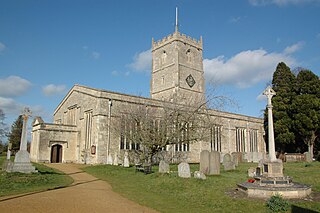
Shrivenham is a village and civil parish in the Vale of White Horse, Oxfordshire, England, about 5 miles (8 km) south-west of Faringdon. The village is close to the county boundary with Wiltshire and about 7 miles (11 km) east-northeast of Swindon. The 2011 Census recorded the parish population as 2,347. The parish is within the historic boundaries of Berkshire; the 1974 boundary changes transferred the Vale of White Horse to Oxfordshire for administrative purposes.

<span class="mw-page-title-main">Grove, Oxfordshire</span> Human settlement in England

Grove is a village and civil parish in Oxfordshire, England. It was part of Berkshire until it was transferred in the 1974 boundary changes.

<span class="mw-page-title-main">Uffington, Oxfordshire</span> Human settlement in England

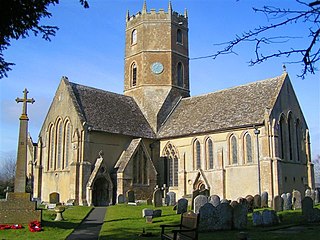
Uffington is a village and civil parish in Oxfordshire, about 4 miles (6.4 km) south of Faringdon and 6 miles (10 km) west of Wantage. The 2011 Census recorded the parish's population as 783. Lying within the historic county boundaries of Berkshire, in 1974 it was transferred for local government purposes to Oxfordshire under the Local Government Act 1972. Uffington is most commonly known for the Uffington White Horse hill figure on the Berkshire Downs in the south of the parish.

<span class="mw-page-title-main">Farnborough, Berkshire</span> Village in England

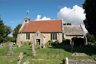
Farnborough is a village and civil parish in West Berkshire, about 4 miles (6.4 km) south of Wantage. The village is 720 feet (220 m) above sea level on a ridge aligned east – west in the Berkshire Downs. It is the highest village in Berkshire.

<span class="mw-page-title-main">Appleford-on-Thames</span> Human settlement in England

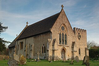
Appleford-on-Thames is a village and civil parish on the south bank of the River Thames about 2 miles (3 km) north of Didcot, in the Vale of White Horse district, in Oxfordshire. It was part of Berkshire until the 1974 local government boundary changes. The 2011 Census recorded the parish's population as 350. On 1 April 2000 the civil parish was renamed from "Appleford" to "Appleford on Thames".

<span class="mw-page-title-main">Baulking</span> Human settlement in England

Baulking or Balking is a village and civil parish about 3+12 miles (5.6 km) southeast of Faringdon in the Vale of White Horse district of Oxfordshire. It was part of Berkshire until the 1974 Boundary Changes transferred it to Oxfordshire.

<span class="mw-page-title-main">Bourton, Vale of White Horse</span> Human settlement in England

Bourton is a village and civil parish in the Vale of White Horse, England, about 4 miles (6.4 km) southeast of Highworth in neighbouring Wiltshire. Bourton was part of the parish of Shrivenham until 1867, and was in Berkshire until the 1974 local government boundary changes transferred the Vale of White Horse to Oxfordshire. The 2011 Census recorded the parish population as 326.

<span class="mw-page-title-main">Drayton, Vale of White Horse</span> Human settlement in England

Drayton is a village and civil parish about 2 miles (3 km) south of Abingdon, Oxfordshire. It was part of Berkshire until the 1974 boundary changes transferred it to Oxfordshire. The parish includes the hamlet of Sutton Wick. The 2011 Census recorded the parish population as 2,353.

<span class="mw-page-title-main">Longcot</span> Human settlement in England

Longcot is a village and civil parish in the Vale of White Horse District. It was part of Berkshire until the 1974 boundary changes transferred it to Oxfordshire. The village is about 3 miles (5 km) south of Faringdon and about 2.5 miles (4 km) northeast of Shrivenham. The A420 road between Swindon and Oxford passes through the parish 1 mile (1.6 km) northwest of the village. The 2011 Census recorded the parish's population as 617.

<span class="mw-page-title-main">Kingston Lisle</span> Human settlement in England

Kingston Lisle is a village and civil parish in the Vale of White Horse, England, about 4+12 miles (7 km) west of Wantage and 5 miles (8 km) south-southeast of Faringdon. The parish includes the hamlet of Fawler, about 12 mile (800 m) west of Kingston Lisle village. The 2011 Census recorded the parish population as 225. Kingston Lisle was part of Berkshire until the 1974 local government boundary changes transferred the Vale of White Horse to Oxfordshire.

<span class="mw-page-title-main">Wootton, Vale of White Horse</span> Human settlement in England

Wootton is a village and civil parish in the Vale of White Horse about 3 miles (5 km) north-west of Abingdon. It was part of Berkshire until the 1974 boundary changes transferred it to Oxfordshire. The parish of Wootton includes the hamlets of Whitecross and Lamborough Hill and the western part of Boars Hill. The 2011 Census recorded the parish's population as 2,709.

<span class="mw-page-title-main">Childrey</span> Human settlement in England

Childrey is a village and civil parish about 2+12 miles (4 km) west of Wantage in the Vale of White Horse. The parish was part of the Wantage Rural District in Berkshire until the 1974 boundary changes transferred the Vale of White Horse to Oxfordshire. The 2021 Census recorded the parish population as 527.

<span class="mw-page-title-main">Steventon, Oxfordshire</span> Human settlement in England

Steventon is a village and civil parish in Oxfordshire, England, about 4 miles (6.4 km) south of Abingdon and a similar distance west of Didcot. It lies within the boundaries of the historic county of Berkshire. The 2011 Census recorded the parish population as 1,485.

<span class="mw-page-title-main">Shellingford</span> Human settlement in England

Shellingford, historically also spelt Shillingford, is a village and civil parish about 2+12 miles (4 km) south-east of Faringdon in the Vale of White Horse in Oxfordshire, England. It was part of Berkshire until the 1974 Local Government Act transferred it to Oxfordshire. The 2011 Census recorded the parish's population as 173.

<span class="mw-page-title-main">East Challow</span> Human settlement in England

East Challow is a village and civil parish about 1 mile (1.6 km) west of Wantage in the Vale of White Horse, England. Historically it was part of the ecclesiastical parish of Letcombe Regis, but since 1852 East and West Challow have formed their own single ecclesiastical parish. The civil parish was part of Berkshire until the 1974 boundary changes transferred the Vale of White Horse to Oxfordshire.

<span class="mw-page-title-main">Sparsholt, Oxfordshire</span> Human settlement in England

Sparsholt is a village and civil parish about 3 miles (5 km) west of Wantage in the Vale of White Horse district of Oxfordshire. The parish includes the hamlet of Westcot about 12 mile (800 m) west of the village. Sparsholt was part of Berkshire until the 1974 boundary changes transferred the Vale of White Horse to Oxfordshire.

West Challow is a village and civil parish about 2 miles (3 km) west of the market town of Wantage in the Vale of White Horse. The village is on Childrey Brook, which is a tributary of the River Ock. West Challow was part of Berkshire until the 1974 boundary changes transferred the Vale of White Horse to Oxfordshire. The 2011 Census recorded the parish's population as 184.

<span class="mw-page-title-main">Dry Sandford</span> Village in Oxfordshire, England

Dry Sandford is a village in the Vale of White Horse district of England, about 3 miles (5 km) north-west of Abingdon. It is one of two villages in the civil parish of St Helen Without. It was part of Berkshire until the 1974 boundary changes transferred the Vale of White Horse to Oxfordshire.

<span class="mw-page-title-main">Goosey</span> Human settlement in England

Goosey is a village and civil parish in England, about 4.5 miles (7 km) northwest of Wantage in the Vale of White Horse. Goosey was part of Berkshire until 1974, when the Vale of White Horse was transferred to Oxfordshire.

References

  1. UK Census (2011). "Local Area Report – Woolstone Parish (1170217907)". Nomis. Office for National Statistics . Retrieved 4 September 2018.
  2. 1 2 3 4 5 6 7 8 9 10 11 12 13 14 Ditchfield & Page 1924 , pp. 543–551
  3. 1 2 3 4 5 6 Pevsner 1966 , p. 313
  4. 1 2 Wintle 2007 , p. 2
  5. Wintle 2007, p. 15.
  6. Wintle 2007, pp. 1, 4.
  7. Wintle 2007, pp. 1, 10.
  8. Wintle 2007, pp. 11–14.
  9. 1 2 Wintle 2007 , p. 1
  10. 1 2 3 Ekwall 1960 , Woolstone
  11. Historic England. "Church of All Saints (Grade II*) (1199074)". National Heritage List for England . Retrieved 4 September 2018.
  12. "Uffington Benefice". Archived from the original on 19 July 2011. Retrieved 9 February 2011.
  13. Historic England. "The White Horse Inn (Grade II) (1199130)". National Heritage List for England .
  14. White Horse at Woolstone
  15. "The White Horse at Woolstone". Our Pubs. Arkell's Brewery. Retrieved 4 September 2018.
  16. Dalby 2000, p. 23.

Bibliography

Commons-logo.svg Media related to Woolstone, Oxfordshire at Wikimedia Commons