Cumnor

Last updated • 3 min readFrom Wikipedia, The Free Encyclopedia

Cumnor
Cumnor church.jpg
St. Michael's parish church
Oxfordshire UK location map.svg
Red pog.svg
Cumnor
Location within Oxfordshire
Population5,755 (2011 Census)
OS grid reference SP4604
Civil parish
  • Cumnor
District
Shire county
Region
Country England
Sovereign state United Kingdom
Post town Oxford
Postcode district OX2
Dialling code 01865
Police Thames Valley
Fire Oxfordshire
Ambulance South Central
UK Parliament
Website Cumnor Parish Council
List of places
UK
England
Oxfordshire
51°44′06″N1°19′55″W / 51.735°N 1.332°W / 51.735; -1.332

Cumnor is a village and civil parish 3½ miles (5.6 km) west of the centre of Oxford, England. The village is about 2 miles (3.2 km) south-west of Botley and its centre is west of the A420 road to Swindon. The parish includes Cumnor Hill, (a ribbon development between Cumnor village and Botley), Chawley (at the top of Cumnor Hill), the Dean Court area on the edge of Botley and the outlying settlements of Chilswell, Farmoor, Filchampstead and Swinford. It was within Berkshire until the 1974 local government boundary changes transferred it to Oxfordshire. The 2011 Census recorded the parish population as 5,755. [1]

Contents

Amenities

Cumnor has two public houses, the Vine and the Bear and Ragged Staff. It has a butcher, a hairdresser, a sub-post office and greengrocer and a complementary health clinic. The newsagent closed in 2018. It has two churches: the Church of England parish church of St Michael in the centre of the village and Cumnor United Reformed Church in Leys Road. The village has well established football and cricket clubs, both located in Appleton Road.

Cumnor Primary School, located in the centre of the village has produced many notable pupils. The Oxford School of Music is in Cumnor Hill. Notable residents in October 2008 included novelist Philip Pullman [2] and celebrity chef Sophie Grigson. [3] The composer and conductor Christopher Whelen lived in Cumnor for several years until his death in 1993.

The Bear and Ragged Staff public house. Cumnor pub.jpg
The Bear and Ragged Staff public house.
An Oxford Bus Company bus in Oxford Road, Cumnor AlexanderDennis Enviro400H HY11 BRD Cumnor.jpg
An Oxford Bus Company bus in Oxford Road, Cumnor

Public transport

Cumnor is served by the Oxford Bus Company routes 4 and 4B to Abingdon [4] and Oxford and Stagecoach in Oxfordshire Gold route S9 to Oxford and Wantage. [5]


Rivers and streams

Cumnor parish adjoins the River Thames on its south bank near Bablock Hythe. The centre of Cumnor village lies 1.5 miles to the east. The source of the Osse Stream is a pond in Cumnor.

History

The earliest known record of Cumnor appears in a Saxon charter of 931 AD as Cumanoran. The Domesday Book of 1086 terms it Comenore. Other medieval spellings include Colmonora and Colmanora. The name derives from Old English for "Cuma's hill-slope". However, a Benedictine called Cumma was Abbot of Abingdon about 730 AD. [6] The parish in the Middle Ages was among the largest in Berkshire. It included Wytham, Seacourt, North Hinksey, South Hinksey and Wootton and was one of several in the Hundred of Hormer. [7] In 1560 Cumnor Place saw the accidental death and rumoured suicide or murder of Amy Robsart, ailing wife of Lord Robert Dudley. The house was pulled down in 1810, [8] because, it was said, her ghost gave locals trouble. In reality the house had become decrepit.

Cumnor includes some houses by Clough Williams-Ellis, the architect noted for his designs for Portmeirion. His Cumnor houses are some of his earliest commissions, including his first commission, Larkbeare (1903–04, completed 1907) on Cumnor Hill, designed whilst he was still a student at the Architectural Association School of Architecture. The other examples are Cutts End House (1911, Appleton Road), Hurstcote (1922, Appleton Road), and Larkbeare Cottage (1910, Cumnor Hill; originally a gardener's cottage associated with Larkbeare). He also designed Cumnor Rise Hospital at a similar time to Larkbeare (designed 1903–1904, completed 1907) but this was demolished in the 1990s. The Kimmeridge Clay Formation outcrops near Cumnor. The dinosaur Cumnoria prestwichii was discovered near Cumnor before 1879 and was named by Harry Govier Seeley in 1888. [9] Thomas Hardy based Lumsdon on Cumnor in his novel Jude the Obscure .

Cumnoria prestwichii was discovered near Cumnor Cumnoria NT.jpg
Cumnoria prestwichii was discovered near Cumnor

See also

Related Research Articles

<span class="mw-page-title-main">Wantage</span> Town and civil parish in Oxfordshire, England

Wantage is a historic market town and civil parish in the Vale of White Horse, Oxfordshire, England. Although within the boundaries of the historic county of Berkshire, it has been administered as part of Oxfordshire since 1974. The town is on Letcombe Brook, 8 miles (13 km) south-west of Abingdon, 24 miles (39 km) north-west of Reading, 15 miles (24 km) south-west of Oxford and 14 miles (23 km) north-west of Newbury.

<span class="mw-page-title-main">Grove, Oxfordshire</span> Human settlement in England

Grove is a village and civil parish in Oxfordshire, England. It was part of Berkshire until it was transferred in the 1974 boundary changes.

<span class="mw-page-title-main">Botley, Oxfordshire</span> Human settlement in England

Botley is a village in the civil parish of Botley and North Hinksey, in the Vale of White Horse district, in the county of Oxfordshire, England, just west of the Oxford city boundary. Historically part of Berkshire, it stands on the Seacourt Stream, a stream running off the River Thames. The intersection of the A34 and A420 is to the village's north.

<span class="mw-page-title-main">North Hinksey</span> Human settlement in England

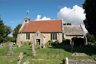
North Hinksey is a village in the civil parish of Botley and North Hinksey, in the Vale of White Horse district, in Oxfordshire, England, on the west side of the Thames flood plain immediately opposite the city of Oxford. The civil parish includes the large settlement of Botley, effectively an isolated suburb of Oxford, with the Botley Road as the sole highway link across the flood plain. North Hinksey was in all respects part of Berkshire until the 1974 boundary changes transferred administration of the Vale of White Horse district to Oxfordshire County Council; it remains part of the historic county of Berkshire however, since the 1974 act did not change the ancient county boundaries. The village of North Hinksey has a manor house, The Fishes public house, a Church of England primary school and a Church of England parish church, St. Lawrence's, which dates back to at least the 12th century. Four of the older houses have thatched roofs.

<span class="mw-page-title-main">Oxford West and Abingdon (UK Parliament constituency)</span> Parliamentary constituency in the United Kingdom since 1983

Oxford West and Abingdon is a constituency represented in the House of Commons of the UK Parliament since 2017 by Layla Moran, a Liberal Democrat.

Abingdon was a rural district in the administrative county of Berkshire from 1894 to 1974.

<span class="mw-page-title-main">South Hinksey</span> Village in Oxfordshire, England

South Hinksey is a village and civil parish just over 1 mile (1.6 km) south of the centre of Oxford. The parish includes the residential area of Hinksey Hill about 0.5 miles (800 m) south of the village. The parish was part of Berkshire until the 1974 boundary changes transferred it to Oxfordshire.

<span class="mw-page-title-main">Southmoor</span> Village in Oxfordshire, England

Southmoor is a village in the civil parish of Kingston Bagpuize with Southmoor, about 6 miles (9.7 km) west of Abingdon, Oxfordshire. Historically part of Berkshire, the 1974 boundary changes transferred local government to Oxfordshire. Southmoor village is just south of the A420 between Oxford and Swindon.

<span class="mw-page-title-main">Wootton, Vale of White Horse</span> Human settlement in England

Wootton is a village and civil parish in the Vale of White Horse about 3 miles (5 km) north-west of Abingdon. It was part of Berkshire until the 1974 boundary changes transferred it to Oxfordshire. The parish of Wootton includes the hamlets of Whitecross and Lamborough Hill and the western part of Boars Hill. The 2011 Census recorded the parish's population as 2,709.

Harcourt Hill is a hill and community in North Hinksey in Oxfordshire, England, west of the city of Oxford. There is a good view of the city from the hill. It lies between Hinksey Hill to the southeast, Boars Hill to the south and Botley to the north. Until 1974 it was in Berkshire, but was transferred to Oxfordshire in that year.

<span class="mw-page-title-main">Hinksey Hill</span> Hill in Oxfordshire, England

Hinksey Hill is a hill and residential area 2 miles (3.2 km) south of the centre of Oxford. It is in South Hinksey civil parish, about 0.5 miles (800 m) south of the village. Hinksey Hill was part of Berkshire until the 1974 boundary changes transferred it to Oxfordshire.

<span class="mw-page-title-main">Seacourt</span> Deserted medieval village in Oxfordshire, UK

Seacourt is a deserted medieval village (DMV) in the civil parish of Wytham, in the Vale of White Horse district, in Oxfordshire, England, near the city of Oxford. The site is now mostly beneath the Oxford Western By-pass (A34), about 0.3 miles (0.48 km) south of the Seacourt/Hinksey Stream crossing.

<span class="mw-page-title-main">Frilford</span> Hamlet in Oxfordshire, England

Frilford is a hamlet and civil parish in the Vale of White Horse district of Oxfordshire, England. It is about 3 miles (4.8 km) west of Abingdon at the junction of the A415 and A338 roads. It was part of Berkshire until it transferred to Oxfordshire in the 1974 boundary changes.

<span class="mw-page-title-main">Chilswell</span> Hamlet in Oxfordshire, England

Chilswell is a small settlement in the parish of Cumnor, Oxfordshire. It lies between the village of South Hinksey and Boars Hill. In 1974 it was transferred from Berkshire.

Dean Court is a suburb 2 miles (3.2 km) west of the centre of Oxford, England. Dean Court was part of Berkshire until the 1974 local government boundary changes transferred it to Oxfordshire.

Hormer was an ancient hundred of Berkshire, England. It consisted of the area immediately west of Oxford within the bend of the River Thames, all of which was transferred to Oxfordshire on 1 April 1974 in accordance with the Local Government Act 1972. It included the ancient parishes of

References

  1. UK Census (2011). "Local Area Report – Cumnor Parish (E04008203)". Nomis. Office for National Statistics . Retrieved 6 December 2019.
  2. Cornwell, John (24 October 2004). "Some enchanted author". The Times Online. Archived from the original on 7 September 2008. Retrieved 6 January 2010.
  3. Grigson, Sophie (1 March 2007). "Sophie's Guide to the World of Vegetables". The Oxford Times "Weekend". Retrieved 6 January 2010.
  4. "4 4B Abingdon ∙ Wootton ∙ Cumnor ∙ Botley ∙ City Centre ∙ Wood Farm 4A Elms Rise 4C Dean Court" (PDF). Oxford Bus Company. 1 September 2019. Retrieved 6 December 2019.
  5. "S9: Wantage - Grove - Oxford" (PDF). Stagecoach in Oxfordshire. 4 August 2019. Retrieved 6 December 2019.
  6. Ekwall 1960, Cumnor.
  7. Powell-Smith, Anna. "Cumnor". Open Domesday. Retrieved 9 April 2017.
  8. "Cumnor Place (Cumnor Hall) (Dudley Castle)". The DiCamillo Companion. Archived from the original on 2 April 2015. Retrieved 8 March 2015.
  9. Seeley, H. G. (1888). "On Cumnoria, an iguanodont genus founded upon the Iguanodon prestwichi, Hulke". Report of the British Association for the Advancement of Science. 57: 698.

Sources and further reading