
Cumnor is a village and civil parish 3½ miles (5.6 km) west of the centre of Oxford, England. The village is about 2 miles (3.2 km) south-west of Botley and its centre is west of the A420 road to Swindon. The parish includes Cumnor Hill,, Chawley, the Dean Court area on the edge of Botley and the outlying settlements of Chilswell, Farmoor, Filchampstead and Swinford. It was within Berkshire until the 1974 local government boundary changes transferred it to Oxfordshire. The 2011 Census recorded the parish population as 5,755.
The River Ock is a small English river which is a tributary of the River Thames. It has as its catchment area the Vale of White Horse, a low-lying and wide valley in south Oxfordshire, and flows into the River Thames, at Abingdon on the reach above Culham Lock.
Cumnor Hill is a hill in the civil parish of Cumnor, to the west of the city of Oxford, in the English county of Oxfordshire. In 1974 it was transferred from Berkshire. It is also the name of the ribbon development between the original Cumnor village and Botley, outside the ring road on the outskirts of Oxford.
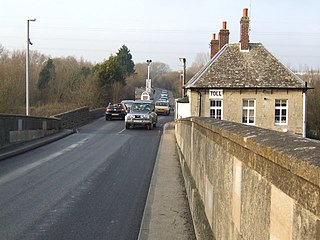
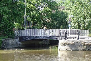
Swinford in the English county of Oxfordshire is a hamlet in the civil parish of Cumnor. It lies on the road between Eynsham and Farmoor (B4044) on the south bank of the River Thames. The Swinford Toll Bridge carrying the B4044 crosses the River Thames here. In 1974 it was transferred from Berkshire to the county of Oxfordshire.

Hurst Hill or Cumnor Hurst is a 20.6-hectare (51-acre) biological and geological Site of Special Scientific Interest west of Oxford in Oxfordshire. It is a Geological Conservation Review site.

The Christ of Havana is a large sculpture representing Jesus of Nazareth, on a hilltop overlooking the bay in Havana, Cuba. It is the work of the Cuban sculptor Jilma Madera, who won the commission for it in 1953.
Kaliszki is a village in the administrative district of Gmina Rawa Mazowiecka, within Rawa County, Łódź Voivodeship, in central Poland. It lies approximately 7 kilometres (4 mi) west of Rawa Mazowiecka and 49 km (30 mi) east of the regional capital Łódź.
Łęki Duże is a village in the administrative district of Gmina Lututów, within Wieruszów County, Łódź Voivodeship, in central Poland. It lies approximately 4 kilometres (2 mi) south of Lututów, 22 km (14 mi) east of Wieruszów, and 86 km (53 mi) south-west of the regional capital Łódź.
Emerytka is a settlement in the administrative district of Gmina Sobolew, within Garwolin County, Masovian Voivodeship, in east-central Poland. It lies approximately 18 kilometres (11 mi) south of Garwolin and 72 km (45 mi) south-east of Warsaw.
Bogusławice is a village in the administrative district of Gmina Skaryszew, within Radom County, Masovian Voivodeship, in east-central Poland.

Chilswell is a small settlement in the parish of Cumnor, Oxfordshire. It lies between the village of South Hinksey and Boars Hill. In 1974 it was transferred from Berkshire.
Żydowo is a village in the administrative district of Gmina Trzciel, within Międzyrzecz County, Lubusz Voivodeship, in western Poland. It lies approximately 10 kilometres (6 mi) west of Trzciel, 13 km (8 mi) south-east of Międzyrzecz, 51 km (32 mi) south-east of Gorzów Wielkopolski, and 54 km (34 mi) north of Zielona Góra.
Stara Wieś is a village in the administrative district of Gmina Nowa Sól, within Nowa Sól County, Lubusz Voivodeship, in western Poland. It lies approximately 3 kilometres (2 mi) south-east of Nowa Sól and 24 km (15 mi) south-east of Zielona Góra.

The Azad University in Oxford (AUO) is a university campus in Oxford, England, branch of the Islamic Azad University, Iran.
Puzdrowski Młyn is a settlement in the administrative district of Gmina Sierakowice, within Kartuzy County, Pomeranian Voivodeship, in northern Poland. It lies approximately 3 kilometres (2 mi) west of Sierakowice, 23 km (14 mi) west of Kartuzy, and 51 km (32 mi) west of the regional capital Gdańsk.
Henwood is a hamlet about 3.5 miles (5.6 km) south-west of Oxford, England. Henwood is in Wootton civil parish in the Vale of White Horse district.
Brownfield is an unincorporated community in northeastern Laclede County, in the U.S. state of Missouri. The community is located just over one mile southeast of the Laclede-Pulaski county line and one mile east of Missouri Route K. It is within the Mark Twain National Forest and the Gasconade River lies just one mile to the east.
Beegum is an unincorporated community in Shasta and Tehama counties, in the U.S. state of California.
