
Oxfordshire is a ceremonial county in South East England. The county is bordered by Northamptonshire and Warwickshire to the north, Buckinghamshire to the east, Berkshire to the south, and Wiltshire and Gloucestershire to the west. The largest settlement is the city of Oxford.
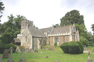
Radley is a village and civil parish about 2 miles (3 km) northeast of the centre of Abingdon, Oxfordshire. The parish includes the hamlet of Lower Radley on the River Thames. It was part of Berkshire until the 1974 boundary changes transferred it to Oxfordshire. The village is home to Radley College, a famous boarding independent school for boys from the age of thirteen to eighteen that consists of 690 pupils.
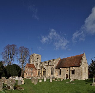
Sutton Courtenay is a village and civil parish on the River Thames 2 miles (3 km) south of Abingdon-on-Thames and 3 miles (5 km) northwest of Didcot. Historically part of Berkshire, it has been administered as part of Oxfordshire since the 1974 boundary changes. The 2011 census recorded the parish's population as 2,421. Sutton Courtenay is home to some important structures, such as The Abbey, the Manor House, All Saints' Church, a twelfth-century Norman hall, the Sutton Bridge, and Didcot power station.

Farnborough is a village and civil parish in West Berkshire, about 4 miles (6.4 km) south of Wantage. The village is 720 feet (220 m) above sea level on a ridge aligned east – west in the Berkshire Downs. It is the highest village in Berkshire.

Shilton is a village and civil parish about 1+1⁄2 miles (2.4 km) northwest of Carterton, Oxfordshire. The 2011 Census recorded the parish's population as 626.

Appleford-on-Thames is a village and civil parish on the south bank of the River Thames about 2 miles (3 km) north of Didcot, in the Vale of White Horse district, in Oxfordshire. It was part of Berkshire until the 1974 local government boundary changes. The 2011 Census recorded the parish's population as 350. On 1 April 2000 the civil parish was renamed from "Appleford" to "Appleford on Thames".
Abingdon was a rural district in the administrative county of Berkshire from 1894 to 1974.

Drayton is a village and civil parish about 2 miles (3 km) south of Abingdon, Oxfordshire. It was part of Berkshire until the 1974 boundary changes transferred it to Oxfordshire. The parish includes the hamlet of Sutton Wick. The 2011 Census recorded the parish population as 2,353.

Charney Bassett is a village and civil parish about 4+1⁄2 miles (7 km) north of Wantage and 6 miles (10 km) east of Faringdon in the Vale of White Horse. It was part of Berkshire until the 1974 boundary changes transferred it to Oxfordshire. The 2011 Census recorded the parish population as 314. The River Ock flows through it, and divides here for a mile or so. The alternative name of the river, Charn or Cearn, may have originally applied to the northern arm only.

Netherton is a hamlet in Fyfield and Tubney civil parish about 5.5 miles (9 km) west of Abingdon. Formerly in the parish of Fyfield before it merged with Tubney in 1952, it was part of Berkshire until the 1974 boundary changes transferred it to Oxfordshire. The toponym is derived from the Old English neotherra meaning "lower, nether" and dun meaning "hill". It was recorded as Netendon in 1193. Netherton is primarily residential. Netherton is linked with Oxford by Pulhams Coaches route 63 bus that runs on Mondays to Fridays.

Marcham is a village and civil parish about 2 miles (3 km) west of Abingdon, Oxfordshire. The 2011 Census recorded the parish's population as 1,905. The parish includes the hamlets of Cothill 1+3⁄4 miles (2.8 km) east-northeast of the village, and Gozzard's Ford 1+1⁄2 miles (2.4 km) northeast of the village. Frilford and Garford used to be townships of Marcham parish, but are now separate civil parishes. All these parishes were part of Berkshire until the 1974 boundary changes transferred them to Oxfordshire.

Appleton is a village in the civil parish of Appleton-with-Eaton, about 4 miles (6.4 km) northwest of Abingdon. Appleton was part of Berkshire until the 1974 boundary changes transferred it to Oxfordshire. The 2011 Census recorded Appleton-with-Eaton's parish population as 915.

Bayworth is a hamlet in the civil parish of Sunningwell about 3 miles (5 km) south of Oxford. Bayworth was part of Berkshire until the 1974 boundary changes transferred it to Oxfordshire.

Milton is a village and civil parish about 3 miles (5 km) west of Didcot and a similar distance south of Abingdon. The 2011 Census recorded the parish's population as 1,290.

West Hendred is a village and civil parish about 3 miles (5 km) east of Wantage. It was part of Berkshire until the 1974 boundary changes transferred it to Oxfordshire. West Hendred is downland village, its parish stretching from the Ridgeway in the south through the spring line and meadows to the former marshland of the Oxfordshire plain in the north. The parish is about 2,000 acres (810 ha) in area and 6 miles (10 km) long, but only being about 1⁄2 mile (800 m) wide at the widest point. This is an example of a downland linear parish encompassing a wide variety of land types – chalk downland, greensand on the spring line and clay to the north. The Great Western Main Line crosses the northern part of the parish. The Icknield Way and The Ridgeway cross the parish in the south.

Fyfield is a village and former civil parish, now in the parish of Fyfield and Tubney, in the Vale of White Horse district, in the county of Oxfordshire, England. It is about 4+1⁄2 miles (7 km) west of Abingdon-on-Thames. It was part of Berkshire until the 1974 boundary changes transferred it to Oxfordshire. The village used to be on the main A420 road between Oxford and Faringdon, but a bypass now carries the main road just south of the village. In 1951 the parish had a population of 280. On 1 April 1952 the parish was abolished and merged with Tubney to form "Fyfield and Tubney".
Lewknor is a village and civil parish about 5 miles (8 km) south of Thame in Oxfordshire.The civil parish includes the villages of Postcombe and South Weston. The 2011 Census recorded the parish's population as 663.
Fyfield and Tubney is a civil parish in The Vale of White Horse district of Oxfordshire, England. It includes the village of Fyfield which is about 4.5 miles (7 km) west of Abingdon and Tubney, which is about 4 miles (6 km) west of Abingdon. The parish was formed in 1952 when the parish of Fyfield was merged with the parish of Tubney. It was part of Berkshire until the 1974 boundary changes transferred it to Oxfordshire.

Goosey is a village and civil parish in England, about 4.5 miles (7 km) northwest of Wantage in the Vale of White Horse. Goosey was part of Berkshire until 1974, when the Vale of White Horse was transferred to Oxfordshire.


