
Wantage is a historic market town and civil parish in the Vale of White Horse, Oxfordshire, England. Although within the boundaries of the historic county of Berkshire, it has been administered as part of Oxfordshire since 1974. The town is on Letcombe Brook, 8 miles (13 km) south-west of Abingdon, 24 miles (39 km) north-west of Reading, 15 miles (24 km) south-west of Oxford and 14 miles (23 km) north-west of Newbury.
The Vale of White Horse is a local government district of Oxfordshire in England. It was historically part of Berkshire. The area is commonly referred to as the 'Vale of the White Horse'. It is crossed by the Ridgeway National Trail in its far south, across the North Wessex Downs AONB at the junction of four counties. The northern boundary is defined by the River Thames. The name refers to Uffington White Horse, a prehistoric hill figure.

Newbury is a constituency of the Parliament of the United Kingdom, located in the English county of Berkshire. It was created by the Redistribution of Seats Act 1885 and has been in continual existence since then. It has been represented by Lee Dillon of the Liberal Democrats since 2024.

Wantage was a constituency in Oxfordshire represented in the House of Commons of the Parliament of the United Kingdom.
Hanney was an ancient ecclesiastical parish about 3 miles (5 km) north of Wantage in the Vale of White Horse. It included the villages of East Hanney and West Hanney and Lyford. Hanney was part of Berkshire until the 1974 boundary changes transferred the Vale of White Horse to Oxfordshire.
Windsor was a rural district in Berkshire, England from 1894 to 1974.

Abingdon was a parliamentary constituency in England, represented in the House of Commons of the Parliament of England until 1707, then of the Parliament of Great Britain from 1707 to 1800 and of the Parliament of the United Kingdom from 1801 to 1885. It elected one Member of Parliament (MP) from 1558 until 1983, making it one of the few English constituencies in the unreformed House of Commons to elect only one Member of Parliament (MP) by the first past the post system of election.

Kingston Lisle is a village and civil parish in the Vale of White Horse, England, about 4+1⁄2 miles (7 km) west of Wantage and 5 miles (8 km) south-southeast of Faringdon. The parish includes the hamlet of Fawler, about 1⁄2 mile (800 m) west of Kingston Lisle village. The 2011 Census recorded the parish population as 225. Kingston Lisle was part of Berkshire until the 1974 local government boundary changes transferred the Vale of White Horse to Oxfordshire.

Childrey is a village and civil parish about 2+1⁄2 miles (4 km) west of Wantage in the Vale of White Horse. The parish was part of the Wantage Rural District in Berkshire until the 1974 boundary changes transferred the Vale of White Horse to Oxfordshire. The 2021 Census recorded the parish population as 527.
Letcombe Regis is a village and civil parish in the Vale of White Horse. It was part of Berkshire until the 1974 boundary changes transferred the Vale of White Horse to Oxfordshire. The village is on Letcombe Brook at the foot of the Berkshire Downs escarpment about 1 mile (1.6 km) southwest of the market town of Wantage. The 2011 Census recorded the parish population as 578.
East Hanney is a village, and civil parish on Letcombe Brook about 3 miles (5 km) north of Wantage. Historically East and West Hanney were formerly a single ecclesiastical parish of Hanney. East Hanney was part of Berkshire until the 1974 boundary changes transferred the Vale of White Horse to Oxfordshire.

West Hanney is a village and civil parish about 3 miles (5 km) north of Wantage, Oxfordshire, England. Historically West and East Hanney were formerly a single ecclesiastical parish of Hanney. East Hanney was part of Berkshire until the 1974 boundary changes transferred the Vale of White Horse to Oxfordshire. The 2011 Census recorded the parish's population as 490.
Faringdon was a rural district in the administrative county of Berkshire from 1894 to 1974.

Letcombe Brook is a 7.5-mile (12 km) stream in the Vale of White Horse in Oxfordshire, England. It rises at the foot of the Berkshire Downs in Letcombe Bassett and flows through Letcombe Regis, Wantage, Grove and East Hanney to join Childrey Brook, which is a tributary of the River Ock, which is a tributary of the River Thames.
East Challow is a village and civil parish about 1 mile (1.6 km) west of Wantage in the Vale of White Horse, England. Historically it was part of the ecclesiastical parish of Letcombe Regis, but since 1852 East and West Challow have formed their own single ecclesiastical parish. The civil parish was part of Berkshire until the 1974 boundary changes transferred the Vale of White Horse to Oxfordshire.
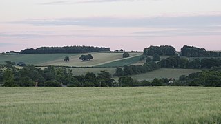
Letcombe Bassett is a village and civil parish about 2 miles (3 km) southwest of the market town of Wantage in the Vale of White Horse. It was part of Berkshire until the 1974 boundary changes transferred the Vale of White Horse to Oxfordshire. The 2011 Census recorded the parish population as 148. The village is a spring line settlement, being the source of Letcombe Brook at the foot of the Berkshire Downs escarpment. Hackpen, Warren & Gramp's Hill Downs Site of Special Scientific Interest is in the parish.

West Challow is a village and civil parish about 2 miles (3 km) west of the market town of Wantage in the Vale of White Horse, England. The village is on Childrey Brook, which is a tributary of the River Ock. West Challow was part of Berkshire until the 1974 boundary changes transferred the Vale of White Horse to Oxfordshire. The 2011 census recorded the parish's population as 184.
Witney Rural District was a rural district in Oxfordshire, England from 1894 to 1974. It surrounded but did not include the town of Witney.


