Henley was a rural district in Oxfordshire, England from 1894 to 1974.
Wortley was a rural district in the West Riding of Yorkshire from 1894 to 1974, situated to the north-west of the county borough of Sheffield.

Wantage was a rural district of Berkshire, England from 1894 to 1974.

Peterborough was a rural district adjoining the city and municipal borough of Peterborough, England, from 1894 to 1974. The council offices were at 51 Priestgate, in the city of Peterborough.
Cookham was a rural district in Berkshire, England from 1894 to 1974.
Windsor was a rural district in Berkshire, England from 1894 to 1974.
Culham was a rural district in Oxfordshire, England from 1894 to 1932. It was formed under the Local Government Act 1894 from the part of the Abingdon Rural Sanitary District in the administrative county of Oxfordshire. The remainder of the sanitary district, in the administrative county of Berkshire, became Abingdon Rural District. The rural district council continued to be based at Abingdon, holding meetings in the workhouse of the poor law union.
Crowmarsh was a rural district in Oxfordshire, England from 1894 to 1932.
Goring was a rural district in Oxfordshire, England from 1894 to 1932.
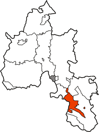
Abingdon was a rural district in the administrative county of Berkshire from 1894 to 1974.
St Helen Without is a civil parish in the Vale of White Horse district in the English county of Oxfordshire. In 1974 it was transferred from Berkshire. It is immediately west of Abingdon and includes the villages of Dry Sandford and Shippon. A large part of the parish is occupied by Dalton Barracks and its associated airfield. According to the 2001 census the parish had a population of 2,623. The parish was created by the Local Government Act 1894, by the division of the parish of Abingdon St. Helen. The part inside Abingdon Municipal Borough became part of Abingdon parish, whilst that part outside became St. Helen Without. It became part of the Abingdon Rural District of Berkshire in 1894, and then part of the Vale of White Horse in Oxfordshire under the Local Government Act 1972.
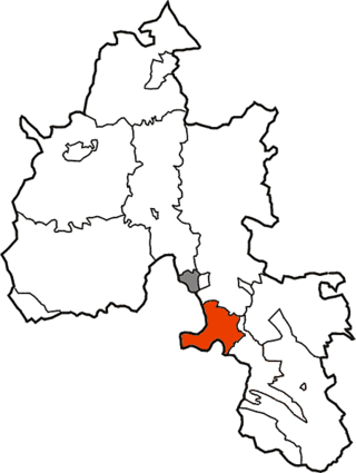
Abingdon was a municipal borough embracing the town of Abingdon-on-Thames in the county of Berkshire from 1835 to 1974. From 1894 it was nearly entirely surrounded by Abingdon Rural District. It was abolished in 1974 under the Local Government Act 1972, and merged with other districts to form the new Vale of White Horse district of Oxfordshire.
The town of Eton formed a local government district in Buckinghamshire, England from 1849 to 1974. It was administered as a local board district from 1849 to 1894, and as an urban district from 1894 to 1974.

Slough was, from 1863 to 1974, a local government district in southern Buckinghamshire, England. It became an urban district in 1894 and was incorporated as a municipal borough in 1938. It was abolished in 1974 and now forms part of the borough of Slough in Berkshire.
Faringdon was a rural district in the administrative county of Berkshire from 1894 to 1974.
Clutton was a rural district in Somerset, England, from 1894 to 1974.
Hungerford Rural District was a rural district in Berkshire, England from 1894 to 1974, covering an area in the south-west of the county.
Newbury Rural District was a rural district in Berkshire, England from 1894 to 1974, covering an area in the south-west of the county which almost surrounded but did not include the town of Newbury.
Chipping Norton Rural District was a rural district in Oxfordshire, England from 1894 to 1974. It surrounded but did not include the town of Chipping Norton.
Witney Rural District was a rural district in Oxfordshire, England from 1894 to 1974. It surrounded but did not include the town of Witney.

