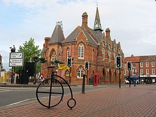
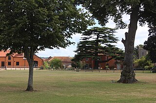
Wokingham is a market town and civil parish in Berkshire, England, 37 miles (60 km) west of London, 7 miles (11 km) southeast of Reading, 8 miles (13 km) north of Camberley and 4 miles (6 km) west of Bracknell. It is the main administrative centre of the wider Borough of Wokingham. In 2011 it had a population of 50,320.
Earley is a town and civil parish in the Borough of Wokingham, Berkshire, England. Along with the neighbouring town of Woodley, the Office for National Statistics places Earley within the Reading/Wokingham Urban Area; for the purposes of local government it falls within the Borough of Wokingham, outside the area of Reading Borough Council. Its name is sometimes spelt Erleigh or Erlegh and consists of a number of smaller areas, including Maiden Erlegh and Lower Earley, and lies some 3 miles (5 km) south and east of the centre of Reading, and some 4 miles (6 km) northwest of Wokingham. It had a population of 32,036 at the 2011 Census.

Chieveley is a village and large civil parish centred 3.5 miles (5.6 km) north of Newbury in Berkshire, close to the M4 motorway and A34 road. Chieveley services are within the parish.
Baydon is a village and civil parish in Wiltshire, England about 10 miles (16 km) south-east of Swindon. The eastern boundary of the parish forms part of the county boundary with Berkshire, and the village is about 7 miles (11 km) north-west of the West Berkshire market town of Hungerford.

Hampstead Norreys is a village and civil parish in Berkshire, England. It is centred on the River Pang, north of Newbury. As well as the nucleus of Hampstead Norreys, the parish includes the hamlets of Bothampstead, Eling and Wyld Court. The village was recorded in the Domesday Book of 1086 as Hanstede.

Tidmarsh is a village in West Berkshire, England. Its development is mainly residential and agricultural, and is centred on the A340 road between Pangbourne and Theale. The rural area is bounded by the M4 motorway to the south. It is centred 1.5 miles (2.4 km) south of Pangbourne, 5.5 miles (8.9 km) west of Reading and 40 miles (64 km) west of London.

Sulhamstead is a village and civil parish in West Berkshire, England. It occupies an approximate rectangle of land south of the (Old) Bath Road (A4) between Reading, its nearest town and Thatcham. It has several small clusters of homes and woodland covering about a fifth of the land, in the centre and north beside which is Thames Valley Police's main Training Centre at Sulhamstead House. Its main amenities are its Church of England parish church and a shop and visitor centre by the Kennet & Avon Canal.

Enborne is a village and civil parish, in West Berkshire, England. The River Enborne shares its name, although it does not run through the village; rather, it runs through and rises near the nearby village of Enborne Row. The village name has had many variant spellings in the past, including Anebourne in 1086, as well as Enbourne, Enborn and Enbourn in the last 200 years.

Frilsham is a village and civil parish 4 miles (6.4 km) from Newbury, in the English county of Berkshire.

Great Shefford is an English village and civil parish on the River Lambourn in the West Berkshire district of Berkshire. The present civil parish includes the historical parish of Little or East Shefford, a small, reduced community downstream. It also covers the village of Shefford Woodlands, about 1.5 miles (2.4 km) south-west of Great Shefford, near Junction 14 on the M4 motorway.
Burghfield is a village and large civil parish in West Berkshire, England, with a boundary with Reading. Burghfield can trace its history back to before the Domesday Book, and was once home to three manors: Burghfield Regis, Burghfield Abbas, and Sheffield. Since the 1980s the population of Burghfield has nearly doubled with the construction of housing estates, making it a dormitory for Reading, Newbury, Basingstoke and the M4 corridor.

Stanford Dingley is a small village and civil parish in West Berkshire, England, between Newbury and Theale.

Henry Norris, 1st Baron Norreys of Rycote in Oxfordshire, was an English politician and diplomat, who belonged to an old Berkshire family, many members of which had held positions at the English court.

Tormarton is a village and civil parish in the South Gloucestershire district, in the ceremonial county of Gloucestershire, England. The village is about half a mile north of the M4 motorway; the A46 road towards Bath passes a similar distance west of the village to join the motorway at junction 18. The parish includes the small village of West Littleton, south of the motorway. The parish population at the 2021 census was 323. The Cotswold Way footpath passes through the village.
Remenham is a village and civil parish on the Berkshire bank of the River Thames opposite Henley-on-Thames in southern England. It is particularly well known for the steep approach, known as Remenham Hill or White Hill, into Henley.

Shinfield is a village and civil parish in the Borough of Wokingham, Berkshire, England. It lies just south of Reading, around 3 miles (4.8 km) from the town centre, and covers an area of 4,313 acres (17.45 km2). Shinfield Park is the northern part of the parish, becoming physically separated from Reading when the M4 motorway was constructed in 1971.
Yattendon Castle was a fortified manor house located in the civil parish of Yattendon, in the hundred of Faircross, in the English county of Berkshire.
Sir John Norreys or Norris was a gentleman usher daily waiter at the English court during the reign of the House of Tudor. He is thought to be the author of a treatise describing the roles of servants of the chamber.

Woodlands St Mary is a small village in the English county of Berkshire. The village is situated in the civil parish of Lambourn, and is 3 miles (4.8 km) to the south of the village of Lambourn, and 1 mile (1.6 km) from Lambourn Woodlands. The parish is within the unitary authority of West Berkshire, close to the border between the counties of Berkshire and Wiltshire.
Fifield is a village in the civil parish of Bray in Berkshire in south east England. The settlement lies near the junction of the M4 and A404(M) motorways, and is situated approximately 3 miles (4.8 km) from Maidenhead and Windsor. The local pub is the Fifield Inn, which was refurbished in 2014.


