
Gomersal is a town in Kirklees in West Yorkshire, England. It is south of Bradford, east of Cleckheaton and north of Heckmondwike. It is close to the River Spen and forms part of the Heavy Woollen District.

Monyash is a village and civil parish in the Peak District, Derbyshire, England, 5 miles (8.0 km) west of the market town Bakewell. It is centred on a village green 265 metres (869 ft) above sea level at the head of Lathkill Dale in the limestone area known as the White Peak. At the 2011 census, it had a population of 314. Tourism and farming are the predominant activities of the village. The area was once an important meeting place, a watering point for drovers’ animals at the intersection of several trade routes, and industrial centre supporting the local lead mining industry.

Billington is a civil parish in Bedfordshire about 3 miles (4.8 km) south of Leighton Buzzard and not far from the Buckinghamshire border. There are two settlements: Little Billington and one that is now called Great Billington.

Whitwick is a large village in Leicestershire, England, close to the town of Coalville in the northwest of the county. It lies in an ancient parish which formerly included the equally historic villages of Thringstone and Swannington. It was an important manor in the Middle Ages, which once included Bardon and Markfield, parts of Hugglescote, Donington le Heath, Ratby, Bocheston, Newtown Unthank and Whittington. As early as 1293, Whitwick had a weekly market and a four-day fair. The population of Whitwick, according to the 2001 census was 10,815 persons. 8,092 of these fell into the 16-74 working age range, although only 4,689 were employed. The population of the village at the 2011 census had fallen to 8,612.

Finchampstead is a village and civil parish in the Wokingham Borough in the shire of Berkshire, England. Its northern extremity is 2 miles (3 km) south of Wokingham, 5 miles (8 km) west of Bracknell, 8 miles (13 km) south-east of Reading, and 34 miles (55 km) west of Central London. It is an affluent area, with the village ranking as Britain's 31st wealthiest. It has a high standard of living and is rated as one of the most desirable places to live in the United Kingdom.

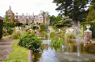
Yattendon is a village and civil parish 7 miles (11 km) northeast of Newbury in the county of Berkshire, England. The M4 motorway passes through the fields of the village which lie 0.5 miles (800 m) south and below the elevations of its cluster. The village is privately owned and is "part of the 9,000 acre estate owned by the Iliffes, former press barons", part of the Yattendon Group.

Leckhampstead is a village and civil parish in West Berkshire, England in the North Wessex Downs. A road and boundary stone in Leckhampstead, the Hangman's Stone and Hangman's Stone Lane, are named after a tale of a man who roped and carried a stolen sheep from a farm in Leckhampstead around his neck, but which strangled him after he stopped and slept. After a long hiatus the area returned to full village status in 1864. Its hamlet of Hill Green has six listed buildings and the amenities of the village include a public house, church and village hall. The associated hamlet of Leckhampstead Thicket has a high proportion of its buildings that are thatched cottages and has a Primitive Methodist chapel, dated 1874.

Pontrobert is an ecclesiastical parish that was formed in September 1854. It comprises the townships of Teirtref and part of Nantymeichiaid in the parish Meifod, a portion of Cynhinfa which was in the parish of Llangynyw and portions of the townships of Fachwel, Llaethbwlch and Cadwnfa which were in the parish of Llanfihangel. The total area of this parish is 5,000 acres. As a result of this arrangement, Pont Robert is now divided between the present day Community Councils of Meifod, Llangyniew and Mawddwy. Pontrobert was within the historic county of Montgomeryshire, now forming part of Powys. The name Pontrobert is derived from Robert ap Oliver of Cyhinfa, who built the original bridge over the River Vyrnwy around 1700. An alternative Welsh name for Pontrobert is Pont y ddolfeiniog.

Hemingby is a dispersed village and civil parish in the East Lindsey district of Lincolnshire, England. It is situated approximately 3 miles (5 km) north from the market town of Horncastle and just west from the junction of the B1225 and A158 roads. It is surrounded by the villages of Baumber, Goulceby and West Ashby. The River Bain and its tributary, the Hemingby Beck, flow through the village.
Nuthurst is a village and civil parish in the Horsham district of West Sussex, England. The north of the parish borders Horsham town, with Nuthurst village 3 miles (5 km) south from the border. Within the parish is the estate and largely 19th-century country house of Sedgwick Park.
Sir John Norreys or Norris was a gentleman usher daily waiter at the English court during the reign of the House of Tudor. He is thought to be the author of a treatise describing the roles of servants of the chamber.

Steventon is a village and civil parish in Oxfordshire, England, about 4 miles (6.4 km) south of Abingdon and a similar distance west of Didcot. It was part of Berkshire until the 1974 boundary changes transferred it to Oxfordshire. The 2011 Census recorded the parish population as 1,485.

Milton is a village and civil parish about 3 miles (5 km) west of Didcot and a similar distance south of Abingdon. The 2011 Census recorded the parish's population as 1,290.

Gedney Dyke is a village in the civil parish of Gedney and the South Holland district of Lincolnshire, England. It is 40 miles (64 km) south-east from the city and county town of Lincoln, and 13 miles (20 km) from both Boston at the north-west and King's Lynn at the south-east.

Woodside is a hamlet in Berkshire, England, within the civil parishes of Winkfield and Sunninghill and Ascot in the boroughs of Bracknell Forest and Windsor and Maidenhead. The settlement lies near to the A332 road and is approximately 1.5 miles (2.4 km) north-east of Ascot Racecourse and largely surrounded by Windsor Great Park. In the early Twentieth Century the south of the hamlet was the site of the Ascot Brick Works. It has two pubs The Rose and Crown and the Duke of Edinburgh but no shops or church, as such it is probably best described as a hamlet and not a village. It features several historic houses and buildings. In the 19th and early 20th Century there were two distinct hamlets:

Cooma Cottage is a heritage-listed former farm and tuberculosis sanatorium and now house museum and historic site at Yass Valley Way, Marchmont, Yass Valley Shire, New South Wales, Australia. It was built from 1830 to 1837 by Cornelius and Rebecca O'Brien. It is also known as Hamilton Hume's House,Humedale Stud, and New Nordrach Institute for Consumption. The property is owned by the National Trust of Australia (NSW). It was added to the New South Wales State Heritage Register on 1 March 2002.

Sydenham is a village and civil parish about 3 miles (5 km) southeast of Thame in Oxfordshire. To the south the parish is bounded by the ancient Lower Icknield Way, and on its other sides largely by brooks that merge as Cuttle Brook, a tributary of the River Thame. The 2011 Census recorded the parish's population as 451.

Langton by Spilsby, sometimes called Langton by Partney, is a village and civil parish in the East Lindsey district of Lincolnshire, England. It is situated approximately 4 miles (6 km) north from the town of Spilsby, Lincolnshire. The civil parish includes the hamlet of Sutterby. From the 2011 census the population is included in the civil parish of Sausthorpe.

Tydd Gote is an English village, partly, at the north, in the civil parish of Tydd St Mary of the South Holland District of Lincolnshire, and partly, at the south, in the civil parish of Tydd St Giles of the Fenland District of Cambridgeshire.

Holbeach Clough is a fenland village in the South Holland district of Lincolnshire, England. It is just under 2 miles (3 km) north from the market town of Holbeach, and on the A17 road. The village is almost conjoined at the east to the village of Holbeach Bank. The village is part of the Holbeach civil parish, and is at the south-west edge of Holbeach Marsh.

