
Newbury is a market town in the county of Berkshire, England, and is home to the administrative headquarters of West Berkshire Council. The town centres around a large market square retains a rare medieval Cloth Hall, an adjoining half timbered granary, and the 15th-century St Nicolas Church, along with 17th- and 18th-century listed buildings. As well as being home to Newbury Racecourse, it is the headquarters of Vodafone and software company Micro Focus International. In the valley of the River Kennet, 26 mi (42 km) south of Oxford, 25 mi (40 km) north of Winchester, 27 mi (43 km) southeast of Swindon and 20 mi (32 km) west of Reading.

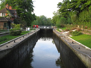
The Kennet and Avon Canal is a waterway in southern England with an overall length of 87 miles (140 km), made up of two lengths of navigable river linked by a canal. The name is used to refer to the entire length of the navigation rather than solely to the central canal section. From Bristol to Bath the waterway follows the natural course of the River Avon before the canal links it to the River Kennet at Newbury, and from there to Reading on the River Thames. In all, the waterway incorporates 105 locks.
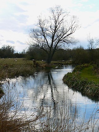
The Kennet is a tributary of the River Thames in Southern England. Most of the river is straddled by the North Wessex Downs AONB. The lower reaches have been made navigable as the Kennet Navigation, which – together with the Avon Navigation, the Kennet and Avon Canal and the Thames – links the cities of Bristol and London.

Hungerford is a historic market town and civil parish in Berkshire, England, 8 miles (13 km) west of Newbury, 9 miles (14 km) east of Marlborough, 27 miles (43 km) north-east of Salisbury and 60 miles west of London. The Kennet and Avon Canal passes through the town alongside the River Dun, a major tributary of the River Kennet. The confluence with the Kennet is to the north of the centre whence canal and river both continue east. Amenities include schools, shops, cafés, restaurants, and facilities for the main national sports. Hungerford railway station is a minor stop on the Reading to Taunton Line.
Sonning Lock is a lock and associated weir situated on the River Thames at the village of Sonning near Reading, Berkshire, England. The first lock was built by the Thames Navigation Commission in 1773 and it has been rebuilt three times since then. There is a weir a little upstream at the top of the island where Sonning Backwater separates from the main course of the river.

Pingewood is a hamlet in the civil parish of Burghfield, to the south of Reading, in the English county of Berkshire. It lies to the Southwest of Burghfield Bridge The name Pingewood derives from the old Celtic word 'pen' meaning head, peak, tip or end. The 'ge' is a contraction of the Celtic word for wood, 'coed'. When the Saxons moved into the area in the 5th century, they did not understand the meaning and added their own descriptive word 'wood' on the end.

Ufton Nervet is a village and civil parish in West Berkshire, England centred 6 miles (10 km) west southwest of the large town of Reading and 7 miles east of Thatcham. Ufton Nervet has an elected civil parish council.

Theale is a village and civil parish in the West Berkshire unitary area of the county of Berkshire, England. It is 5 miles (8 km) southwest of Reading and 10 miles (16 km) east of Thatcham. The compact parish is bounded to the south and south-east by the Kennet & Avon Canal, to the north by a golf course, to the east by the M4 motorway and to the west by the A340 road.

Southcote is a suburb of Reading in the English county of Berkshire. Located to the south-west of Reading town centre, Southcote has a population of about 8,500. The settlement lies primarily between the London-to-Bath road and the River Kennet.

Foudry Brook is a small stream in southern England. It rises from a number of springs near the Hampshire village of Baughurst, and flows to the east and then the north, to join the River Kennet to the south of Reading. The upper section is called Silchester Brook, and beyond that, Bishop's Wood Stream. The underlying geology is chalk, covered by a layer of clay, and so it has the characteristics of a clay stream, experiencing rapid increases in level after heavy rain due to run-off from the surrounding land. It passes a number of listed buildings and scheduled monuments, including the site of the Roman town of Calleva Atrebatum or Silchester.
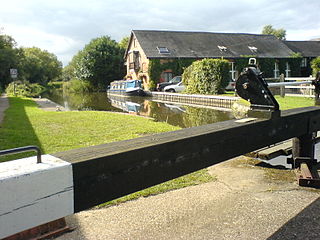
Southcote Lock is a lock on the River Kennet at Southcote near the town of Reading in Berkshire, England. It has a rise/fall of 5 feet 3 inches (1.60 m).

Sulhamstead is a village and civil parish in West Berkshire, England. It occupies an approximate rectangle of land south of the (Old) Bath Road (A4) between Reading, its nearest town and Thatcham. It has several small clusters of homes and woodland covering about a fifth of the land, in the centre and north beside which is Thames Valley Police's main Training Centre at Sulhamstead House. Its main amenities are its Church of England parish church and a shop and visitor centre by the Kennet & Avon Canal.

Beech Hill is a small village and civil parish in Berkshire, England. It is in the south east of the West Berkshire unitary authority area and bounds Hampshire and Wokingham district.
Burghfield is a village and large civil parish in West Berkshire, England, with a boundary with Reading. Burghfield can trace its history back to before the Domesday Book, and was once home to three manors: Burghfield Regis, Burghfield Abbas, and Sheffield. Since the 1980s the population of Burghfield has nearly doubled with the construction of housing estates, making it a dormitory for Reading, Newbury, Basingstoke and the M4 corridor.

Sonning Eye is a hamlet on the River Thames in the Sonning Common ward of South Oxfordshire, England, in the civil parish of Eye & Dunsden, at what is since 1974 the southernmost tip of Oxfordshire.

Wokefield is a hamlet and civil parish in the West Berkshire district of Berkshire, England, south of Reading. The parish includes the hamlets of Goddard's Green and Bloomfield Hatch. It also includes part of the former parish of Sulhamstead and Grazeley.

John Hore was an English engineer, best known for making the River Kennet and River Avon navigable. Hore was one of the earliest English canal engineers, and Sir Alec Skempton wrote that he was "in the first rank among the navigation engineers". The Hutchinson Chronology of World History described his work on the Kennet navigation as "[setting] a new standard for inland waterways, and is an important forerunner of the canals of the Industrial Revolution".

High Bridge, sometimes known as Duke Street Bridge, is a bridge across the River Kennet in the town centre of Reading in the English county of Berkshire. It links Duke Street, to its north, and London Street, to its south. High Bridge is the oldest surviving bridge across the Kennet, and is a grade II listed building. It comprises a single arch of vermiculated Portland stone, with a plain keystone of ashlar.
John Blackwell was an English civil engineer, known for his work as superintending engineer of the Kennet and Avon Canal under John Rennie and later as the canal company's resident engineer.

