Borough of Slough

Last updated

Borough of Slough
Slough town centre.png
Wentworth Avenue, Britwell - geograph.org.uk - 162775.jpg
Wexham - St Mary's Church - geograph.org.uk - 1114106.jpg
Colnbrook High Street - geograph.org.uk - 4231076.jpg
Langley Marish, St. Mary's Church - geograph.org.uk - 4966397.jpg
Slough UK locator map.svg
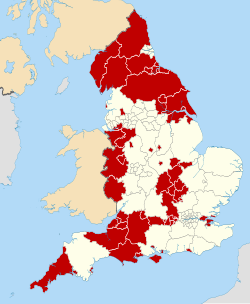
Slough shown within Berkshire
Sovereign state United Kingdom
Constituent country England
Region South East England
Commuter Belts London Commuter Belt
Ceremonial county Berkshire
Constituencies Slough
Seat Slough
Area
  Total20.80 sq mi (53.88 km2)
  Rank 276th
Population
 (2021)
  Total158,289
  Rank Ranked 129th
  Density7,600/sq mi (2,900/km2)
Ethnicity (2021)
[1]
   Ethnic groups
List
Religion (2021)
[1]
   Religion
List
Time zone UTC+0 (Greenwich Mean Time)
  Summer (DST) UTC+1 (British Summer Time)
Postcode
SL1-3, SL60-95 (Non-geographic)
Area code SL
ONS code 00EH (ONS)
E06000039 (GSS)
Website www.slough.gov.uk

The Borough of Slough is a unitary authority with borough status in the ceremonial county of Berkshire, Southern England. The borough is centred around the town of Slough and includes Langley. It forms an urban area with parts of Buckinghamshire and extends to the villages of Burnham, Farnham Royal, George Green, and Iver. Part of the district's area was in Buckinghamshire prior to the district's formation and in Middlesex until 1965. [2]

Contents

History

The borough was formed on 1 April 1974 under the Local Government Act 1972 from the Municipal Borough of Slough and parts of the parishes of Burnham and Wexham of which were formerly in Eton Rural District in Buckinghamshire. [3] On 1 April 1995 the parish of Colnbrook with Poyle was transferred to Slough. [4]

Geography

The borough borders the counties of Buckinghamshire (the unitary authority of the same name), Greater London (Hillingdon) and Surrey (Spelthorne), as well as the Royal Borough of Windsor and Maidenhead (also in Berkshire). Notable settlements nearby including London, Reading and High Wycombe. The nearest airport is Heathrow Airport, which is located roughly 7 miles (11 km) to the south-east. The borough has good links to London and other towns and cities with its main connecting road being the M4 motorway. It is also served by six railway stations: Taplow, Burnham, Slough, Langley, Iver and West Drayton. The district contains the unparished area of Slough and the civil parish of Colnbrook with Poyle. [5] The parishes of Britwell and Wexham Court were scheduled for abolition in April 2019, but after an appeal by the parish councils and a judicial review the order was quashed and the parishes remain unchanged. [6] [7]

Council and cabinet

2021 Slough Borough Council election [8] [9]
PartyThis electionFull councilThis election
SeatsNetSeats %OtherTotalTotal %VotesVotes %+/−
  Labour 11Decrease2.svg 178.6233481.017,22757.6-1.4
  Conservative 2Steady2.svg14.33511.99,07230.3+1.9
  Independent 1Increase2.svg 17.1237.11,9876.6+0.4
  Liberal Democrats 0Steady2.svg0.0000.09393.1-0.6
  Green 0Steady2.svg0.0000.06352.1+0.3
  Heritage 0Steady2.svg0.0000.0660.2New

Wards

The borough comprises 15 wards:

Related Research Articles

<span class="mw-page-title-main">Slough</span> Town in Berkshire, England

Slough is a town in Berkshire, England, in the Thames Valley 20 miles (32 km) west of central London and 19 miles (31 km) north-east of Reading, at the intersection of the M4, M40 and M25 motorways. It is part of the historic county of Buckinghamshire. In 2021 Census, the population of the town was 143,184. In 2021, the wider Borough of Slough had a population of 158,500. Slough borders the counties of Greater London and Buckinghamshire.

<span class="mw-page-title-main">Britwell</span> Human settlement in England

Britwell is a residential housing estate and civil parish in the north west of Slough, Berkshire, South East England. It is about 23 miles (37 km) west of Charing Cross, the centremost point of London.

<span class="mw-page-title-main">Colnbrook</span> Village in Berkshire, England

Colnbrook is a village in the Slough district in Berkshire, England. It lies within the historic boundaries of Buckinghamshire, and straddles two distributaries of the Colne, the Colne Brook and Wraysbury River. These two streams have their confluence just to the southeast of the village. Colnbrook is centred 3 miles (4.8 km) southeast of the Slough town centre, 4 miles (6.4 km) east of Windsor, and 19 miles (31 km) west of central London.

<span class="mw-page-title-main">Langley, Berkshire</span> Human settlement in England

Langley, also known as Langley Marish, is an area of Slough in Berkshire, South East England. It is two miles (3 km) east of Slough town centre and 18 miles (29 km) west of Charing Cross in Central London. It was a separate civil parish and village until the 1930s, when the built-up part of Langley was incorporated into Slough. Langley was in the historic county of Buckinghamshire, being transferred to the administrative county of Berkshire in 1974.

<span class="mw-page-title-main">Wexham</span> Human settlement in England

Wexham is a civil parish straddling the ceremonial counties of Berkshire and Buckinghamshire in southern England. Wexham Park Hospital is a large hospital on the parish border and Burnham Beeches, a forest takes in small parts of its northern land. Wexham is in the county of Buckinghamshire while Wexham Court is in the county of Berkshire.

<span class="mw-page-title-main">South Bucks</span> Former non-metropolitan district in England

South Bucks was one of four local government districts in the non-metropolitan county of Buckinghamshire, in South East England.

<span class="mw-page-title-main">Poyle</span> Human settlement in England

Poyle is a largely industrial and agricultural area in the unitary authority of Slough, in the ceremonial county of Berkshire, England. It is located 18.5 miles (30 km) west of Charing Cross in London and immediately west of the M25 motorway, near Heathrow Airport; it also adjoins the Colne Valley regional park.

<span class="mw-page-title-main">Slough (UK Parliament constituency)</span> Parliamentary constituency in the United Kingdom, 1983 onwards

Slough is a constituency represented in the House of Commons of the UK Parliament by Tan Dhesi, a member of the Labour Party, since the 2017 UK general election.

<span class="mw-page-title-main">Beaconsfield (UK Parliament constituency)</span> Parliamentary constituency in the United Kingdom since 1974

Beaconsfield is a constituency in Buckinghamshire represented in the House of Commons of the UK Parliament since 2019 by Joy Morrissey of the Conservative Party. She succeeded Independent and former Conservative Dominic Grieve, whom she defeated following his suspension from the party. The constituency was established for the February 1974 general election.

Eton Rural District was a rural district in the administrative county of Buckinghamshire, England, covering an area in the south-east of the county. It was named after but did not contain Eton, which was an urban district.

Colnbrook with Poyle is a civil parish in the borough of Slough in Berkshire, England. Located approximately 17 miles (27 km) west of central London and adjacent to the Greater London boundary, it is an urbanised parish with some industrial development and open land. The local council is Colnbrook with Poyle Parish Council. The parish was created on 1 April 1995 as an amalgamation of Colnbrook from the parish of Iver with Poyle from an unparished area. At the 2001 census it had a population of 5,426.

Slough Borough Council is the local authority for Slough, a unitary authority in Berkshire, England. Until 1 April 1998 it was a non-metropolitan district.

Elections to Slough Borough Council were held on 4 May 2006. One third of the council was up for election. This was the 121st Slough general local authority election since Slough became a local government unit in 1863.

<span class="mw-page-title-main">Slough Borough Council</span> Local authority in England

Slough Borough Council is the local authority for the Borough of Slough, in Berkshire, England. Slough is a unitary authority, having the powers of a county and district council combined. Berkshire is purely a ceremonial county, with no administrative responsibilities.

An election to Slough Borough Council was held on 10 June 2004. The whole council was up for election. This was the 120th Slough general local authority election, since Slough became a local government unit in 1863, including both whole Council elections and elections by thirds.

Elections to the Borough Council in Slough, England, were held on 3 May 2007. One third of the council was up for election. This was the 122nd Slough general local authority election since Slough became a local government unit in 1863.

Slough is a town and unitary authority in the English county of Berkshire, just to the west of Greater London. Until 1974 the town was in Buckinghamshire.

<span class="mw-page-title-main">Thorney Interchange</span>

The Thorney Interchange is a large motorway intersection in the UK, between the M4 and M25. It is one of the busiest motorway interchanges in the country. It lies on the edges of Buckinghamshire, Greater London and Berkshire, and is close to Surrey and Staines-upon-Thames.

References

  1. 1 2 UK Census (2021). "2021 Census Area Profile – Slough Local Authority (E06000039)". Nomis. Office for National Statistics . Retrieved 5 January 2024.
  2. "Slough, town and unitary authority, Berkshire, England, United Kingdom". Encyclopædia Britannica . Retrieved 15 May 2022.
  3. "The English Non-metropolitan Districts (Definition) Order 1972". legislation.gov.uk . Retrieved 15 May 2022.
  4. "The Berkshire, Buckinghamshire and Surrey (County Boundaries) Order 1994". legislation.gov.uk. Retrieved 16 May 2022.
  5. "Slough". Ordnance Survey . Retrieved 15 May 2022.
  6. "The Slough Borough Council (Reorganisation of Community Governance) Order 2019" (PDF). Local Government Boundary Commission for England . Retrieved 13 May 2019.
  7. "Community Governance Review 2018, Judicial review". Slough Borough Council.
  8. "Slough scoreboard". BBC . Retrieved 26 June 2021.
  9. "2021 Local borough election". Slough Borough Council. Retrieved 26 June 2021.