Mole Valley

Last updated

Mole Valley District
Leatherhead Bridge - geograph.org.uk - 5410353.jpg
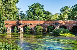
Bridge over the River Mole at Leatherhead
Motto(s): 
Ministrando vigilans
(Latin: Vigilant in our serving)
Mole Valley UK locator map.svg
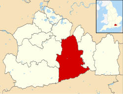
Mole Valley shown within Surrey
Sovereign state United Kingdom
Constituent country England
Region South East England
Non-metropolitan county Surrey
Status Non-metropolitan district
Admin HQ Dorking
Incorporated1 April 1974
Government
  TypeNon-metropolitan district council
  BodyMole Valley District Council
Area
  Total99.7 sq mi (258.3 km2)
  Rank133rd (of 296) Highest point  : Leith Hill
Population
 (2021)
  Total87,608
  Rank270th (of 296)
  Density880/sq mi (340/km2)
  Ethnicity
97.4% White
Time zone UTC0 (GMT)
  Summer (DST) UTC+1 (BST)
ONS code 43UE (ONS)
E07000210 (GSS)
OS grid reference TQ0496458567

Mole Valley is a local government district in Surrey, England. Its council is based in Dorking, and the district's other town is Leatherhead. The largest villages are Ashtead, Fetcham and Great Bookham, in the northern third of the district.

Contents

Most of the district is on the escarpments of or adjoins the Surrey Hills, a designated Area of Outstanding Natural Beauty, which cover parts of the North Downs and Greensand Ridge, including locally Leith Hill, Polesden Lacey and Box Hill. Denbies Wine Estate, the largest vineyard in the country, is on the hills north-west of Dorking. [1] The Pilgrims' Way footpath runs along the North Downs. There are stations on the LondonWorthing and ReadingGatwick Airport railways, and in the northern third, a commuter stopping-service pattern line, LondonGuildford (via Epsom) line.

The A24 road and the M25 motorway are the main thoroughfares and relative to London the incidence of car ownership is high. The area hosts hill-focussed sub-laps of the London–Surrey Classic cycling tour each year.

The neighbouring districts are Epsom and Ewell, Reigate and Banstead, Crawley, Horsham, Waverley, Guildford, Elmbridge and Kingston upon Thames, the latter being a London borough.

History

The district was created on 1 April 1974 under the Local Government Act 1972, covering three former districts which were all abolished at the same time: [2] [3]

The new district was named after the River Mole, which flows through the area. [4]

Governance

Mole Valley District Council
Mole Valley District Council logo.svg
Type
Type
Leadership
Patricia Wiltshire,
Ashtead Ind.
since 23 May 2023 [5]
Stephen Cooksey,
Liberal Democrat
since 21 May 2019
Karen Brimacombe
since 2017
Structure
Seats39 councillors
Political groups
Administration (30)
  Liberal Democrats (30)
Other parties (9)
  Ashtead Ind. (6)
  Conservative (3)
Elections
First past the post
Last election
4 May 2023
Next election
2 May 2024
Meeting place
Pippbrook (geograph 5534840).jpg
Pippbrook, Dorking, RG14 1SJ
Website
www.molevalley.gov.uk
South Holmwood South Holmwood View Redlands.JPG
South Holmwood

Mole Valley District Council provides district-level services. County-level services are provided by Surrey County Council. [6] Parts of the district are covered by civil parishes, which form a third tier of local government for their areas. [7]

Political control

The council has been under Liberal Democrat majority control since 2019.

The first elections to the council were held in 1973, initially operating as a shadow authority alongside the outgoing authorities until the new arrangements came into effect on 1 April 1974. Political control of the council since 1974 has been as follows: [8] [9]

Party in controlYears
No overall control 1974–1980
Independent 1980–1982
No overall control 1982–1994
Liberal Democrats 1994–1995
No overall control 1995–2006
Conservative 2006–2010
No overall control 2010–2015
Conservative 2015–2018
No overall control 2018–2019
Liberal Democrats 2019–present

Leadership

The leaders of the council since 2012 have been: [10]

CouncillorPartyFromTo
James Friend Conservative May 2012
Chris Townsend [11] Independent May 2012May 2015
James Friend Conservative May 20152016
Vivienne Michael Conservative 20165 May 2019
Stephen Cooksey Liberal Democrats 21 May 2019

Composition

Following the 2023 election the composition of the council was: [12]

PartyCouncillors
Liberal Democrats 30
Ashtead Independents6
Conservative 3
Total39

The next election is due in 2024.

Elections

Since the last boundary changes in 2023 the council has comprised 39 councillors representing 13 wards, with each ward electing three councillors. Elections are held three years out of every four, with a third of the council (one councillor for each ward) elected each time for a four-year term of office. Surrey County Council elections are held in the fourth year of the cycle when there are no district council elections. [13]

Most of the district lies within the Mole Valley constituency, the exception being Ashtead which is within the Epsom and Ewell constituency. [7]

Premises

Pippbrook House: Council's offices until 1984. Pippbrook House (geograph 5534191).jpg
Pippbrook House: Council's offices until 1984.

The council is based at Pippbrook on Reigate Road in Dorking, which was purpose-built for the council and opened in 1984. [14] It was built in the grounds of a large Victorian house, called Pippbrook House, which had served as the headquarters of the old Dorking Urban District Council from 1931 and then as Mole Valley District Council's headquarters until the new building opened. [15]

Towns and parishes

The former Leatherhead Urban District, which included Ashtead, Fetcham, Great Bookham and Little Bookham, is an unparished area, as is the majority of the former Dorking Urban District. [7] [16]

The rest of the district is covered by civil parishes: [17] [18]

Demographics

A Legatum Prosperity Index published by the Legatum Institute in October 2016 showed Mole Valley as the second most prosperous council area in the United Kingdom, after the nearby Borough of Waverley. [19]

Churches graded II* or above

St Nicolas, Great Bookham St Nicolas, East Window - geograph.org.uk - 675258.jpg
St Nicolas, Great Bookham
St John, Wotton Church of St John the Evangelist, Wotton - geograph.org.uk - 660290.jpg
St John, Wotton
St Michael, Mickleham St Michaels Mickleham.jpg
St Michael, Mickleham
St Michael's Betchworth, 13th century, used in Four Weddings and a Funeral St. Michael's Church, Betchworth, Surrey - geograph.org.uk - 517235.jpg
St Michael's Betchworth, 13th century, used in Four Weddings and a Funeral
ChurchPlace Listed building
Class
St MichaelBetchworthI [20]
St NicolasGreat BookhamI [21]
All SaintsLittle BookhamII*
St Nicholas CharlwoodI [22]
St MichaelMicklehamI [23]
St John the EvangelistWottonI [24]
St Mary & St NicholasLeatherheadII* [25]
St BarnabasRanmore CommonII* [26]
St MaryPixhamII* [27]
St Martin DorkingII* [28]
St MaryFetchamII* [29]
St GilesAshteadII* [30]
St JamesAbinger CommonII* [31]
Holy TrinityWestcottII* [32]
St BartholomewLeighII* [33]
St MargaretOckleyII* [34]
St John the BaptistWalliswoodII* [35]

Emergency services

Mole Valley is served by these emergency services:

Freedom of the District

See also

Related Research Articles

<span class="mw-page-title-main">Ashtead</span> Village in Surrey, England

Ashtead is a large village in the Mole Valley district of Surrey, England, approximately 15.5 mi (25 km) south of central London. Primarily a commuter settlement, Ashtead is on the single-carriageway A24 between Epsom and Leatherhead. The village is on the northern slopes of the North Downs and is in the catchment area of The Rye, a tributary of the River Mole.

<span class="mw-page-title-main">Leatherhead</span> Human settlement in England

Leatherhead is a town in the Mole Valley district of Surrey, England, about 17 mi (27 km) south of Central London. The settlement grew up beside a ford on the River Mole, from which its name is thought to derive. During the late Anglo-Saxon period, Leatherhead was a royal vill and is first mentioned in the will of Alfred the Great in 880 AD. The first bridge across the Mole may have been constructed in around 1200 and this may have coincided with the expansion of the town and the enlargement of the parish church.

<span class="mw-page-title-main">Fetcham</span> Human settlement in England

Fetcham is a suburban village in Surrey, England west of the town of Leatherhead, on the other side of the River Mole and has a mill pond, springs and an associated nature reserve. The housing, as with adjacent Great Bookham, sits on the lower slopes of the North Downs north of Polesden Lacey (NT). Fetcham Grove has Leatherhead and the village's main leisure centre and football club, between the two settlements. Fetcham has two short parades of shops and services, several sports teams and parks and a small number of large pubs and food premises.

<span class="mw-page-title-main">River Mole</span> Tributary of the River Thames in southern England

The River Mole is a tributary of the River Thames in southern England. It rises in West Sussex near Gatwick Airport and flows northwest through Surrey for 80 km to the Thames at Hampton Court Palace. The river gives its name to the Surrey district of Mole Valley.

<span class="mw-page-title-main">Epsom and Ewell (UK Parliament constituency)</span> UK Parliament constituency since 1974

Epsom and Ewell is a constituency in Surrey represented in the House of Commons of the UK Parliament since 2001 by Chris Grayling, a Conservative.

<span class="mw-page-title-main">Charlwood</span> Human settlement in England

Charlwood is a village and civil parish in the Mole Valley district of Surrey, England. It is immediately northwest of London Gatwick Airport in West Sussex, close west of Horley and north of Crawley. The historic county boundary between Surrey and Sussex ran to the south of Gatwick Airport. Boundaries were reformed in 1974 so that the county boundary between Surrey and West Sussex, delineated by the Sussex Border Path, now runs along the northern perimeter of the airport, and the southern extent of Charlwood.

<span class="mw-page-title-main">Mole Valley (UK Parliament constituency)</span> Parliamentary constituency in the United Kingdom, 1983 onwards

Mole Valley is a constituency in Surrey represented in the House of Commons of the UK Parliament since 1997 by Sir Paul Beresford, a Conservative.

<span class="mw-page-title-main">Betchworth</span> Human settlement in England

Betchworth is a village and civil parish in the Mole Valley district of Surrey, England. The village centre is on the north bank of the River Mole and south of the A25 road, almost 3 miles (4.8 km) east of Dorking and 3 miles (4.8 km) west of Reigate. London is 19.5 miles (31.4 km) north of the village.

Epsom was a rural district of Surrey from 1894 to 1933.

<span class="mw-page-title-main">Headley, Surrey</span> Human settlement in England

Headley is a village and civil parish in the North Downs in Surrey, England. The nearest settlements are, to the west, Mickleham and Leatherhead; to the north, Ashtead and Langley Vale; to the east, Walton-on-the-Hill; and to the south, Box Hill. It is just outside the M25 motorway encircling London.

<span class="mw-page-title-main">Leatherhead railway station</span> Railway station in Surrey, England

Leatherhead railway station is in Leatherhead, Surrey, England. It is managed by Southern, with services provided by them and South Western Railway. It is 18 miles 2 chains (29 km) from London Waterloo.

Salfords and Sidlow is a civil parish in the Reigate and Banstead borough of Surrey, England. It has a population of 3,069. The parish includes the villages of Salfords and Sidlow.

<span class="mw-page-title-main">Mole Valley District Council elections</span>

One third of Mole Valley District Council in Surrey, England is elected each year, followed by one year when there is an election to Surrey County Council instead.

<span class="mw-page-title-main">Pixham</span> Human settlement in England

Pixham is a chapelry within the parish of Dorking, Surrey on the near side of the confluence of the River Mole and the Pipp Brook to its town, Dorking, which is centred 1 km (0.6 mi) southwest. The town as a whole, uniquely in Surrey, has three railway stations; Pixham adjoins or is the location of two of the three; and is near the junction of the A24 and A25 main roads.

<span class="mw-page-title-main">Ashtead Park</span>

Ashtead Park is a 24.2-hectare (60-acre) Local Nature Reserve in Ashtead in Surrey. It is owned by Mole Valley District Council. It contains several important listed buildings. The Park itself has remains of a Roman building, four lakes/ponds and the school's playing fields and is Grade II listed on the Register of Historic Parks and Gardens.

<span class="mw-page-title-main">Providence Chapel, Charlwood</span> Church in Surrey , United Kingdom

Providence Chapel is a former Nonconformist place of worship in the village of Charlwood in the English county of Surrey. Founded in 1816 on the outskirts of the ancient village, it was associated with Independent Calvinists and Strict Baptists throughout nearly two centuries of religious use. The "startling" wooden building—remarkably un-English with its simple veranda-fronted style—had seen several years of service as an officers' mess at a nearby barracks. The chapel was put up for sale in 2012. English Heritage has listed it at Grade II* for its architectural and historical importance. It was also on that body's Heritage at Risk Register because of its poor structural condition, but repairs were carried out and in 2019 it was deemed no longer at risk.

References

  1. "Government information about visitor attractions at Denbie's". Surrey County Council. Archived from the original on 1 September 2012. Retrieved 5 May 2012.
  2. "The English Non-metropolitan District (Definition) Order 1972", legislation.gov.uk , The National Archives, SI 1972/2039, retrieved 17 November 2023
  3. "Charlwood and Horley Act 1974", legislation.gov.uk , The National Archives, 1974 c. 11, retrieved 13 January 2024
  4. "The English Non-metropolitan Districts (Names) Order 1973", legislation.gov.uk , The National Archives, SI 1973/551, retrieved 3 January 2024
  5. "Council minutes, 23 May 2023". Mole Valley District Council. Retrieved 13 January 2024.
  6. "Local Government Act 1972", legislation.gov.uk , The National Archives, 1972 c. 70, retrieved 31 May 2023
  7. 1 2 3 "Election Maps". Ordnance Survey. Retrieved 9 January 2023.
  8. "Compositions calculator". The Elections Centre. Retrieved 9 September 2022.
  9. "Mole Valley". BBC News Online . 19 April 2009. Retrieved 7 May 2010.
  10. "Council minutes". Mole Valley District Council. Retrieved 15 July 2022.
  11. Martin, Guy (25 May 2012). "Tory-independent union to continue in Mole Valley". Surrey Live. Retrieved 15 July 2022.
  12. "Local elections 2023: live council results for England". The Guardian.
  13. "The Mole Valley (Electoral Changes) Order 2023", legislation.gov.uk , The National Archives, SI 2023/49, retrieved 13 January 2024
  14. "The war-time library goes up market into mansion". Dorking and Leatherhead Advertiser. 14 February 1986. p. 16. Retrieved 13 January 2024.
  15. "Dorking". West Sussex Gazette. 10 December 1931. p. 4. Retrieved 13 January 2024.
  16. "Surrey: Diagram showing administrative boundaries, 1971". National Library of Scotland. Ordnance Survey. Retrieved 13 January 2024.
  17. "Surrey County Council website". Archived from the original on 3 September 2012. Retrieved 5 May 2012.
  18. "Parish Councils". Mole Valley District Council. Retrieved 13 January 2024.
  19. Braiden, Gerry (13 October 2016). "Scots authority named amongst UK's top 10 most prosperous – as neighbouring city props up table". HeraldScotland. Retrieved 11 September 2020.
  20. Historic England. "Details from listed building database (1378131)". National Heritage List for England . Retrieved 5 May 2012.
  21. Historic England. "Details from listed building database (1028641)". National Heritage List for England . Retrieved 5 May 2012.
  22. Historic England. "Details from listed building database (1248610)". National Heritage List for England . Retrieved 15 July 2016.
  23. Historic England. "Details from listed building database (1028835)". National Heritage List for England . Retrieved 5 May 2012.
  24. Historic England. "Details from listed building database (1294098)". National Heritage List for England . Retrieved 5 May 2012.
  25. Historic England. "Details from listed building database (1190429)". National Heritage List for England . Retrieved 5 May 2012.
  26. Historic England. "Details from listed building database (1189879)". National Heritage List for England . Retrieved 5 May 2012.
  27. Historic England. "Details from listed building database (1279086)". National Heritage List for England . Retrieved 5 May 2012.
  28. Historic England. "Details from listed building database (1028904)". National Heritage List for England . Retrieved 5 May 2012.
  29. Historic England. "Details from listed building database (1378187)". National Heritage List for England . Retrieved 5 May 2012.
  30. Historic England. "Details from listed building database (1028685)". National Heritage List for England . Retrieved 5 May 2012.
  31. Historic England. "Details from listed building database (1378082)". National Heritage List for England . Retrieved 5 May 2012.
  32. Historic England. "Details from listed building database (1227892)". National Heritage List for England . Retrieved 5 May 2012.
  33. Historic England. "Details from listed building database (1028748)". National Heritage List for England . Retrieved 5 May 2012.
  34. Historic England. "Details from listed building database (1028694)". National Heritage List for England . Retrieved 5 May 2012.
  35. Historic England. "Details from listed building database (1028844)". National Heritage List for England . Retrieved 5 May 2012.
  36. Martin, Guy (2 July 2013) [25 May 2010]. "Headley Court granted district's highest honour". Surrey Live. Retrieved 3 May 2023.

51°18′57.68″N0°29′37.31″W / 51.3160222°N 0.4936972°W / 51.3160222; -0.4936972