Ockley

Last updated

Ockley
Ockley Green.JPG
Ockley Green
Surrey UK location map.svg
Red pog.svg
Ockley
Location within Surrey
Area13.75 km2 (5.31 sq mi)
Population871 (Civil Parish 2011) [1]
  Density 63/km2 (160/sq mi)
OS grid reference TQ1540
Civil parish
  • Ockley
District
Shire county
Region
Country England
Sovereign state United Kingdom
Post town Dorking
Postcode district RH5
Dialling code 01306
Police Surrey
Fire Surrey
Ambulance South East Coast
UK Parliament
List of places
UK
England
Surrey
51°08′53″N0°21′47″W / 51.148°N 0.363°W / 51.148; -0.363 Coordinates: 51°08′53″N0°21′47″W / 51.148°N 0.363°W / 51.148; -0.363

Ockley is a rural village in Surrey. It lies astride the A29, the modern road using the alignment of Stane Street (Chichester). The A29 diverges from the A24 from London about 2.5 miles northeast and takes the alignment of Stane Street a mile north of the village. It has a medieval parish church, see list of places of worship in Mole Valley.

Contents

History

Finds of small artifacts dating to Roman Britain associated with the Roman road stretching from Chichester to London have been made since at least the 19th century. [2]

Ockley's name initially appears to fit the uncertain site where battle took place described in the entry for the year 851 of the Anglo-Saxon Chronicle . According to the chronicler, king Æthelwulf and his son Æthelbald, together with the West-Saxon army, fought against an invading Danish army of 350 ships that had plundered London and Canterbury previously, and had also put king Beorhtwulf of Mercia to flight. The chronicler refers to the battlefield as Aclea, Oak Lea, and the Danish army was defeated suffering “the greatest slaughter… we have heard tell of up to this present day”. However, Aclea almost always appears in modern English as Oakley not Ockley and the identification of Ockley with the battlefield is made virtually impossible. [3]

Ockley appears in Domesday Book of 1086 as Hoclei. It was held by Radulf (Ralph) from Richard Fitz Gilbert. Its domesday assets were: 1 hide. It had 5 ploughs, woodland worth 20 hogs. It rendered £3 10s 0d to its overlords per year. [4]

Nicholas Culpeper, a leading Stuart period herbalist, was probably born here on 18 October 1616. [5]

In 1911 the parish was "agricultural, except for a little brick and tile making". [2]

Sports

Informal football is generally played on Ockley Green which has football posts in place.

Ockley Cricket Club celebrated its 170th anniversary in 2022. League matches are played on Saturdays with friendly games on Sundays.

Ockley has Gatton Manor Golf Course on the outskirts of the village, within the parish bounds. [6]

The village has featured in longer routes of the London-Surrey Cycle Classic.

Geography

Between Dorking and Horsham, close to the Sussex/Surrey border, Ockley stretches to the escarpment of Leith Hill, the second highest point in South East England, after Walbury Hill in the far south-west of Berkshire. The northern border is marked by the Greensand Ridge. Close to the Greensand Ridge are small beds of Sussex marble, and remnants of a former limestone area of the Weald. [2]

Transport

Roads

The A29 is the main road through the village with Horsham to the south and Dorking to the north. Local minor roads provide relatively straight access from just north of the village's developed area to Ewhurst and Cranleigh to the west and Capel to the east.

Rail

The village is served by Ockley railway station which is 2 miles (3.2 km) to the east, due to a Victorian aristocrat having imposed his manor's name on a station closer to Capel, Surrey.

Demography and housing

2011 Census Homes
Output areaDetachedSemi-detachedTerracedFlats and apartmentsCaravans/temporary/mobile homesshared between households [1]
(Civil Parish)1471324418110

The average level of accommodation in the region composed of detached houses was 28%, the average that was apartments was 22.6%.

2011 Census Key Statistics
Output areaPopulationHouseholds% Owned outright% Owned with a loanhectares [1]
(Civil Parish)87135234.7%26.7%1375

The proportion of households in the civil parish who owned their home outright compares to the regional average of 35.1%. The proportion who owned their home with a loan compares to the regional average of 32.5%. The remaining % is made up of rented dwellings (plus a negligible % of households living rent-free).

See also

Related Research Articles

Dorking Market town in Surrey, England

Dorking is a market town in Surrey in South East England, about 34 km (21 mi) south of London. It is in Mole Valley District and the council headquarters are to the east of the centre. The High Street runs roughly east–west, parallel to the Pipp Brook and along the northern face of an outcrop of Lower Greensand. The town is surrounded on three sides by the Surrey Hills Area of Outstanding Natural Beauty and is close to Box Hill and Leith Hill.

West Sussex County of England

West Sussex is a county in South East England on the English Channel coast. The ceremonial county comprises the shire districts of Adur, Arun, Chichester, Horsham, and Mid Sussex, and the boroughs of Crawley and Worthing. Covering an area of 1,991 square kilometres, West Sussex borders Hampshire to the west, Surrey to the north, and East Sussex to the east. The county town and only city in West Sussex is Chichester, located in the south-west of the county. This was legally formalised with the establishment of West Sussex Council in 1888 but within the ceremonial Sussex. After the reorganisation of local government in 1974, the ceremonial function of the historic county of Sussex was divided into two separate counties, West Sussex and East Sussex. The existing East and West Sussex councils took control respectively, with Mid Sussex and parts of Crawley being transferred to the West Sussex administration from East Sussex. In the 2011 census, West Sussex recorded a population of 806,900.

A24 road (England)

The A24 is a major road in England that runs for 53.2 miles (85.6 km) from Clapham in south-west London to Worthing on the English Channel in West Sussex via the suburbs of south-west London, as well as through the counties of Surrey and West Sussex.

Mickleham, Surrey Village in Surrey, England

Mickleham is a village in south east England, between the towns of Dorking and Leatherhead in Surrey. The civil parish covers 7.31 square kilometres and includes the hamlet of Fredley. The larger ecclesiastical parish includes the majority of the neighbouring village of Westhumble, from which Mickleham is separated by the River Mole.

Stane Street (Chichester) Roman road in southern England

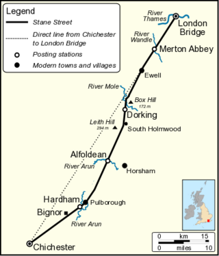
Stane Street is the modern name of the 91 km-long (57 mi) Roman road in southern England that linked Londinium (London) to Noviomagus Reginorum (Chichester). The exact date of construction is uncertain; however, on the basis of archaeological artefacts discovered along the route, it was in use by 70 AD and may have been built in the first decade of the Roman occupation of Britain.

Merstham Human settlement in England

Merstham is a town in the borough of Reigate and Banstead in Surrey, England. It is north of Redhill and is contiguous with it. Part of the North Downs Way runs along the northern boundary of the town. Merstham has community associations, an early medieval church and a football club.

A29 road

The A29 is a main road in England in Surrey and chiefly in West Sussex that runs for 34.3 miles (55.2 km).

Bletchingley Human settlement in England

Bletchingley is a village in Surrey, England. It is on the A25 road to the east of Redhill and to the west of Godstone, has a conservation area with medieval buildings and is mostly on a wide escarpment of the Greensand Ridge, which is followed by the Greensand Way.

Newdigate Human settlement in England

Newdigate is a village and civil parish in the Mole Valley borough of Surrey lying in a relatively flat part of the Weald to the east of the A24 road between Dorking and Horsham, 13 miles (21 km) ESE of Guildford and 25 miles (40 km) south of London. Neighbouring parishes are Charlwood, North Holmwood, South Holmwood, Leigh and Capel.

Abinger Civil parish in Mole Valley, Surrey, England

Abinger is a large, well-wooded and mostly rural civil parish that lies between the settlements of Dorking, Shere and Ewhurst in the district of Mole Valley, Surrey, England.

Shere Village in England

Shere is a village in the Guildford district of Surrey, England 4.8 miles (7.7 km) east south-east of Guildford and 5.4 miles (8.7 km) west of Dorking, centrally bypassed by the A25. It is a small still partly agricultural village chiefly set in the wooded 'Vale of Holmesdale' between the North Downs and Greensand Ridge with many traditional English features. It has a central cluster of old village houses, shops including a blacksmith and trekking shop, tea house, art gallery, two pubs and a Norman church. Shere has a CofE infant and nursery school with 'outstanding academic results' catering for 2- to 7-year-old children which serves the village and surrounding villages and towns, and a museum which opens most afternoons at weekends.

Headley, Surrey Human settlement in England

Headley is a village and civil parish in the North Downs in Surrey, England. The nearest settlements are, to the west, Mickleham and Leatherhead; to the north, Ashtead and Langley Vale; to the east, Walton-on-the-Hill; and to the south, Box Hill. It is just outside the M25 motorway encircling London.

Holmwood railway station Railway station in Surrey, England

Holmwood railway station serves the villages of Beare Green and South Holmwood in Surrey, England, on the Sutton and Mole Valley Lines between Dorking and Horsham, 27 miles 5 chains (43.6 km) from London Waterloo.

Ockley railway station Railway station in Surrey, England

Ockley railway station serves the villages of Ockley and Capel in Surrey, England and is 1.4 miles (2.3 km) from Ockley village and 0.5 miles (0.80 km) west of the village of Capel. The station is 29 miles 20 chains (47.1 km) from London Waterloo station. Ockley is managed by Southern which also provide the services.

Warnham Human settlement in England

Warnham is a village and civil parish in the Horsham district of West Sussex, England. The village is centred 2 miles (3.2 km) north-northwest of Horsham, 31 miles (50 km) from London, to the west of the A24 road. Other named settlements within the parish include the hamlets of Goosegreen, Kingsfold and Winterfold as well as parts of Strood Green and Rowhook. The area is in the northwest of the Weald, a gently sloped remnant forest in southeast England and largely a plain by erosion.

Capel, Surrey Human settlement in England

Capel is a village and civil parish in southern Surrey, England. It is equidistant between Dorking and Horsham – about 5 miles (8.0 km) away. Around Capel, to the west, skirts the A24 road. Capel is approximately 2.5 miles (4.0 km) north of the West Sussex border, 26 miles (42 km) south of London and 12 miles (19 km) southeast of Guildford and is in the Mole Valley district. The village is in the north of a landscape called the Weald, meaning forest, which forms a significant minority of the land today, particularly towards the Greensand Ridge.

South Holmwood Human settlement in England

South Holmwood is a semi-rural village in Surrey, England. It can be considered cognate with its wider civil parish, which stretches to the east to embrace Holmwood Common, but does not include Mid Holmwood, or North Holmwood, the latter being contiguous with Dorking. Betchett's Brook is the southern boundary and runs through a locality known as Holmwood Corner. However, Holmwood railway station is within the parish of Capel, although connected to the South Holmwood by a curved path passing through Holmwood Corner Common. Centred 3 miles (4.8 km) south of Dorking, South Holmwood is on the A24 London to Worthing road, a dual carriageway through the village.

Pixham Human settlement in England

Pixham is a chapelry within the parish of Dorking, Surrey on the near side of the confluence of the River Mole and the Pipp Brook to its town, Dorking, which is centred 1 km (0.6 mi) southwest. The town as a whole, uniquely in Surrey, has three railway stations; Pixham adjoins or is the location of two of the three; and is near the junction of the A24 and A25 main roads.

The Horsham, Dorking and Leatherhead Railway (HDLR) was an early railway company in southern England. It completed earlier plans for a line through the Mole Valley, joining several important towns across the North Downs. It was promoted and later acquired by the London, Brighton and South Coast Railway (LBSCR), and became an essential part of the route later known as the Portsmouth Line.

References

  1. 1 2 3 Key Statistics; Quick Statistics: Population Density United Kingdom Census 2011 Office for National Statistics Retrieved 21 November 2013
  2. 1 2 3 H.E. Malden, ed. (1911). "Parishes: Ockley". A History of the County of Surrey: Volume 3. Institute of Historical Research. Retrieved 29 November 2013.
  3. Frank Stenton: Anglo-Saxon England p244. ISBN   9780192801395
  4. Surrey Domesday Book
  5. Curry, Patrick (2004). "Culpeper, Nicholas (1616–1654), physician and astrologer" . Oxford Dictionary of National Biography (online ed.). Oxford University Press. doi:10.1093/ref:odnb/6882. ISBN   978-0-19-861412-8.(Subscription or UK public library membership required.)
  6. Gatton Manor Retrieved 2013-11-29

Commons-logo.svg Media related to Ockley at Wikimedia Commons