Pixham is a chapelry (small village) within the parish of Dorking, Surrey on the near side of the confluence of the River Mole and the Pipp Brook to its town, Dorking, which is centred 1km (0.6mi) southwest. The town as a whole, uniquely in Surrey, has three railway stations; Pixham adjoins or is the location of two of the three; and is near the junction of the A24 and A25 main roads.
Until 1910 watermills principally for corn grinding and for fulling at Pixham Mill operated, however its agricultural land has been converted to other use. At the 2011 Census the main land use was residential land; its main business being the head office of Friends Provident (which has since been taken over by Aviva), small employers include a school, large inn and a waste water treatment works. Pixham[n 1] covers 117 hectares (290 acres).
Geography
The village is at the steep foot of the Box Hill stretch of the North Downs, on gently facing slopes leading up to the town of Dorking itself. To the east is the confluence of the River Mole and the Pipp Brook, to the west is the Mole Valley railway line. Elevations on the south border of the village reach 60m above sea level (15m higher than the average river level, which descends three metres through the village).[2]
History
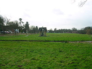
Pixham Mill when in use (c.1890)17th Century Pixham Mill Cottage
No mention is made of Pixham in Domesday Book, but evidence of Roman occupation, including coins, tiles and pottery shards, was discovered on the site of the Friends Provident Sports Ground in 1980;[citation needed] the adjoining road is part of the original line of one of the (Roman) Stane Streets in England. The first reference to Pixham despite centuries of recorded Rolls at Westminster[n 2] comes from a Manor Court Roll of 1417, as a farmed locality with mills but it never gained its own manor.[3]
Giles Green which is no longer visible, north of the Pixham End building by the A24 London Road had the Cock Inn and the Dorking Tollgate with a milestone. A gravel pit for a few years existed in the 20th century on the Friends Provident playing fields here.[4]
At Reverend James Fisher's boarding school in Pixham Daniel Defoe was a pupil.[4] In 1910 watermills for corn grinding at Pixham Mill came to an end.[5][6]
Economy
Pixham End offices
Friends Provident at Pixham End, built in 1957,[4] is the largest employer in Dorking with its insurance, pensions and financial planning UK Head Office[7] in this buffered locality of Dorking. The main land use is residential, the other large businesses being Betchworth Park Golf Course and The Watermill Inn directly to the south and a waste water treatment works on the eastern boundary.[4]
Demography
The United Kingdom Census 2011 considered the village as three output areas, at which time overwhelmingly with gardens,[8] 361 homes formed the village.
The proportion of households in the three divisions of Pixham who owned their home outright was in two of these 15% and 22% above the national average respectively, and slightly greater than the district average. The proportion who owned their home with a loan was in each output area within 2% of the borough and national average. This provides in each area for a lower proportion than average of rented residential property and of social housing relative to the Surrey and national averages.
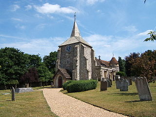
The church of St Mary, a chapel of ease to Dorking parish church has a barrel-vaulted ceiling; is in the centre and was designed by the architect Sir Edwin Lutyens in 1903. Due purely to its architecture not its age is ranked above the other three listed buildings in the village in the mid-category rather than starting level category at Grade II*.[9] Non-eucharist services for the whole community take place on the majority of Sundays at this church.[10]
Pixham Mill
The present plain three-storey brick building dates from 1837 replacing an earlier one. The machinery was driven by a 13ft diameter overshot wheel. The mill was operated by an Attlee family (who also ran Parsonage Mill) from 1882 until milling ceased in 1910. The machinery was removed in 1937 for use in a Sussex mill. During World War II Moss Bros. used the building as a warehouse. It is now a private house, but the water channels remain.[11] The house and the adjacent cottage were flooded three feet deep at Christmas 2013.
Pixham Mill Cottage
Two centuries older than the adjacent listed house named after Pixham Mill here by having been built in the first half of the 17th century, this timber-framed cottage with painted brick infill is Grade II listed and the oldest home in the settlement.[12]
Old Castle Mill
This four-storey red brick, early 19th century mill has some of its machinery intact, however appears to have been defunct by 1912[6] and is a private house.[13]
Primary School
This is the main amenity in the village. It is supported by the mother church to St Mary's Chapel in the village, St Martin's, Dorking and is a Church of England primary school with playing fields.
Transport
Roads
The only through road in the village is Pixham Lane, which has a traffic-light controlled tunnel near the middle of the village. The village is bounded to the west by the A24, a dual carriageway after Junction 9 of the M25 (4 miles (6.4km) north) as far as Horsham, West Sussex where there is then an interchange for Crawley or Brighton, which are linked by the M23. The narrower A25 road passes through the far south of the locality.
In east–west routes the south of the village adjoins the A25 which makes Dorking itself and the Reigate-Redhill conurbation accessible, and features in the London-Surrey cycle classic routes.
At Surrey County Council, one of the 81 representatives represents the area within the Dorking Hills division.[14]
At Mole Valley District Council. Pixham is in the portion of wards considered more rural than suburban so smaller and represented under the constitution by one councillor.[15]
↑ Harbison, Robert (1993). The Shell Guide to English Parish Churches. London: BCA. ISBN978-0-233-98793-4.
1 2 H.E. Malden, ed. (1911). "Parishes: Dorking". A History of the County of Surrey: Volume 3. Institute of Historical Research. Retrieved 7 November 2013.
↑ Registered Offices Friends Provident International Ltd. Retrieved 7 November 2013
Dorking is a market town in Surrey in South East England about 21 mi (34 km) south of London. It is in Mole Valley District and the council headquarters are to the east of the centre. The High Street runs roughly east–west, parallel to the Pipp Brook and along the northern face of an outcrop of Lower Greensand. The town is surrounded on three sides by the Surrey Hills National Landscape and is close to Box Hill and Leith Hill.
The River Mole is a tributary of the River Thames in southern England. It rises in West Sussex near Gatwick Airport and flows northwest through Surrey for 80 km to the Thames at Hampton Court Palace. The river gives its name to the Surrey district of Mole Valley.
Mole Valley is a local government district in Surrey, England. Its council is based in Dorking, and the district's other town is Leatherhead. The largest villages are Ashtead, Fetcham and Great Bookham, in the northern third of the district.
The A24 is a major road in England that runs for 53.2 miles (85.6 km) from Clapham in south-west London to Worthing on the English Channel in West Sussex via the suburbs of south-west London, as well as through the counties of Surrey and West Sussex.
The A25 road is an east–west main road in the South-East of England. Its carries traffic east from Guildford, Surrey, eastward through Surrey and into mid-west Kent, to the town of Sevenoaks, and then on to Wrotham Heath where it connects with the A20.
Mickleham is a village in south east England, between the towns of Dorking and Leatherhead in Surrey. The civil parish covers 7.31 square kilometres and includes the hamlet of Fredley. The larger ecclesiastical parish includes the majority of the neighbouring village of Westhumble, from which Mickleham is separated by the River Mole.
Mole Valley is a former constituency in Surrey represented in the House of Commons of the UK Parliament since 1997 by Sir Paul Beresford, a Conservative, until it was abolished in 2024, primarily replaced by Dorking and Horley.
Westcott is a village in central Surrey, England, about 1.5 miles (2.5 km) west of the centre of Dorking. It is in the Mole Valley district and the Surrey Hills Area of Outstanding Natural Beauty. The Pipp Brook, a tributary of the River Mole, runs to the north of the centre and the settlement is between Ranmore Common on the North Downs and Leith Hill on the Greensand Ridge.
Newdigate is a village and civil parish in the Mole Valley borough of Surrey lying in a relatively flat part of the Weald to the east of the A24 road between Dorking and Horsham, 13 miles (21 km) ESE of Guildford and 25 miles (40 km) south of London. Neighbouring parishes are Charlwood, North Holmwood, South Holmwood, Leigh and Capel.
Abinger is a large, well-wooded and mostly rural civil parish that lies between the settlements of Dorking, Shere and Ewhurst in the district of Mole Valley, Surrey, England.
Shere is a village in the Guildford district of Surrey, England 4.8 miles (7.7 km) east south-east of Guildford and 5.4 miles (8.7 km) west of Dorking, centrally bypassed by the A25. Located on the River Tillingbourne it is a small still partly agricultural village chiefly set in the wooded Vale of Holmesdale between the North Downs and Greensand Ridge. As of 2011 the village had a population of 1,032.
Betchworth is a village and civil parish in the Mole Valley district of Surrey, England. The village centre is on the north bank of the River Mole and south of the A25 road, almost 3 miles (4.8 km) east of Dorking and 3 miles (4.8 km) west of Reigate. London is 19.5 miles (31.4 km) north of the village.
Buckland is a village and civil parish in the Mole Valley district of Surrey, England, between Dorking and Reigate, its nearest towns. The civil parish is bordered by the North Downs escarpment in the north. The area contains a number of sand pits.
Westhumble is a village in south east England, approximately 2 km (1.2 mi) north of Dorking, Surrey. The village is not part of a civil parish, however the majority of the settlement is in the ecclesiastical Parish of Mickleham.
Capel is a village and civil parish in southern Surrey, England. It is equidistant between Dorking and Horsham – about 5 miles (8.0 km) away. Around Capel, to the west, skirts the A24 road. Capel is approximately 2.5 miles (4.0 km) north of the West Sussex border, 26 miles (42 km) south of London and 12 miles (19 km) southeast of Guildford and is in the Mole Valley district. The village is in the north of a landscape called the Weald, meaning forest, which forms a significant minority of the land today, particularly towards the Greensand Ridge.
Ockley is a rural village in Surrey. It lies astride the A29, the modern road using the alignment of Stane Street (Chichester). The A29 diverges from the A24 from London about 2.5 miles northeast and takes the alignment of Stane Street a mile north of the village. It has a medieval parish church, see list of places of worship in Mole Valley.
South Holmwood is a semi-rural village in Surrey, England. It can be considered cognate with its wider civil parish, which stretches to the east to embrace Holmwood Common, but does not include Mid Holmwood, or North Holmwood, the latter being contiguous with Dorking. Betchett's Brook is the southern boundary and runs through a locality known as Holmwood Corner. However, Holmwood railway station is within the parish of Capel, although connected to the South Holmwood by a curved path passing through Holmwood Corner Common. Centred 3 miles (4.8 km) south of Dorking, South Holmwood is on the A24 London to Worthing road, a dual carriageway through the village.
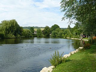
The Pipp Brook is a left-bank tributary of the River Mole, Surrey, England. It rises at two main springs north of Leith Hill on the Greensand Ridge, then descends steeply in a northward direction, before flowing eastwards along the Vale of Holmesdale. It runs to the north of Dorking High Street, before discharging into the Mole at Pixham.
Goodwyns is a housing estate in Dorking, a market town in Surrey, England. It is on the return slope of one of two hillsides of the town and adjoins North Holmwood, a green-buffered village. The town centre is about 1.7 miles (2.7 km) away.
This page is based on this Wikipedia article Text is available under the CC BY-SA 4.0 license; additional terms may apply. Images, videos and audio are available under their respective licenses.