Abinger

Last updated

Abinger
Civil parish
Abinger Common Fields.jpg
Looking across arable land from Abinger Common towards Abinger Hammer
Surrey UK location map.svg
Red pog.svg
Abinger
Location within Surrey
Area30.17 km2 (11.65 sq mi)
Population1,905 (UK Census 2011) [1]
  Density 63/km2 (160/sq mi)
OS grid reference TQ1101
Civil parish
  • Abinger
District
Shire county
Region
Country England
Sovereign state United Kingdom
Post town Dorking
Postcode district RH5
Dialling code 01306
Police Surrey
Fire Surrey
Ambulance South East Coast
UK Parliament
List of places
UK
England
Surrey
51°12′N0°23′W / 51.20°N 0.39°W / 51.20; -0.39 Coordinates: 51°12′N0°23′W / 51.20°N 0.39°W / 51.20; -0.39

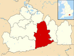
Abinger is a large, well-wooded and mostly rural civil parish that lies between the settlements of Dorking, Shere and Ewhurst in the district of Mole Valley, Surrey, England.

Contents

It adjoins Wotton Common on the same side of Leith Hill and includes Abinger Hammer, Sutton Abinger, Abinger Common, Forest Green, Walliswood, Oakwood Hill and some outskirts of Holmbury St Mary. More than half of the parish lies on the Greensand Ridge, while the remainder is divided between the Vale of Holmesdale and the North Downs.

Geography

Abinger, including the dependent villages of Forest Green and Walliswood, ranks third in size in Surrey after Farnham and Cranleigh. [1] Its list of localities is as set out in the introduction and make up what is called a strip parish reaching from the North Downs to the border of West Sussex, the only parish in Surrey to do so. [2] The entire area is in the Surrey Hills AONB.

Streams and forest

The upper reach of the Tilling Bourne runs through Abinger Hammer from east to west and is joined by the Holmbury St Mary stream on the western border. In the southwest by Sutton Abinger are Pasture Wood and Oxmoor Copse, lower forested slopes of the Greensand Ridge, projections from the Winterfold/Hurt Wood forest.

Hills

Southeast the land approaches the highest point in the Greensand Ridge, climbing through Abinger Common, more than halfway up Leith Hill, reaching in the south-east corner of the parish an elevation of 248 m (814 ft) above sea level. [3] Similarly to the north the parish reaches the top of the North Downs in the protruding arm of Mole Valley, across Abinger Roughs including the highest point before the northern boundary, in Oaken Grove, at Dunley Hill 227 m (745 ft) above sea level; the parish here has the 11th highest hill in Surrey along part of the fluctuating North Downs scarp. [4] The lowest point is where the Tilling Bourne flows into Gomshall at 85 m (279 ft).

Transport

Roads
Abinger Hammer lies on the A25 Guildford to Dorking road, while the remainder of the area is served by more minor roads.
Rail
The nearest railway station is to the west at Gomshall on the North Downs Line from Reading to Gatwick.

History

Abinger Manor Motte Abinger Motte - geograph.org.uk - 817469.jpg
Abinger Manor Motte

A mesolithic burial site on the south east of Abinger Common is testament to the long time in which the area has been inhabited. There is also evidence of strip farming. [5] Remains of a Romano-British villa, a Scheduled Ancient Monument, lie approximately 120 m east of Abinger Hall stables. [6]

Abinger is recorded in Domesday Book as Abinceborne held by William son of Ansculf. It was assessed for tax at 6 hides in 1066 and 4 hides by 1086. There was land for 9 plough teams with 2 plough teams working the lord's land. There were 10 villagers and 7 smallholders with a further 5 plough teams. There was a church and 5 slaves, 1 mill worth 6  s, 3 acres of meadow; and from woodland and pasture the manor rendered 40 pigs. The total value in 1066 was £8, and when acquired by William son of Ansculf and in 1086 was £7. [7] [8]

St James's Church, Abinger Common Church at Abinger Common - geograph.org.uk - 1159849.jpg
St James's Church, Abinger Common

The church of the Abingers is the C of E church of St James at Abinger Common, which is a II* class listed building whose nave is 11th century, chancel and north chapel built 1220 CE, reconstructed in 1857, damaged by a V1 flying bomb in 1944, [9] and restored 1950 by Frederick Etchells. [10] The headquarters of the Lutyens Trust is based in the village at Goddards (designed by Sir Edwin Lutyens). Lutyens also designed Abinger Common War Memorial. Opposite the church is the 19th century Evelyn Hall which has recently been completely refurbished and can be hired for events. To the west of the village is Oxmoor Copse which is an Area of Outstanding Natural Beauty.

The church of St John the Baptist in Walliswood also has class II* listed building status. [11]

The Abinger Hatch The Abinger Hatch - geograph.org.uk - 817511.jpg
The Abinger Hatch

Sutton Abinger has a pub called The Volunteer and 0.5 miles (0.80 km) east in Abinger Common is the Scheduled Ancient Monument Motte "Castle" at Abinger Manor, [12] the grade II listed manor itself [13] and opposite St James Church are three-person stocks [14] and a public house, the Abinger Hatch, which dates from the 17th century, timber framed, clad in whitewashed brick with whitewashed render and with a green picnic area. [15]

Abinger Hammer contains two grade II* listed buildings, Paddington farmhouse, which is 15th century, listed as possibly earlier, extended in the 16th century, which is also whitewashed; and Crossways farmhouse built 1610, clad in sandstone blocks with brick dressings with a panelled 17th century door. [15] [16] Crossways is the setting for George Meredith's 1885 novel, Diana of the Crossways . [9]

Fulvens House, which also lies between the Abingers, is actually over the western border [17] [18] and it may date back to 1628. [19]

Demographics, economy and housing

In 2001, Abinger had a population of 1,858 in 717 households. Abinger covers an area of 30.17 square kilometres (11.65 sq mi). [1] Of the population 12.2% were aged over 65; 3.8% of the population were in full-time further education; 85.1% of all men were economically active whereas 2.8% were unemployed, 6.1% worked part-time; 60% of all women were economically active whereas 2.7% were unemployed, 34.6% worked part-time. [20]

As to ethnicity, 99.94% of the population identified themselves as being white, 6 residents identified with one of the other main categories. [20]

In terms of religion, 77.7%% of the population responded as being Christian, 0% as Muslim, 0.8% other religions, 13.7% as atheist and 8.2% declined to answer. [20]

Abinger's economy is predominantly one in the service sector reflected by a low concentration at one end of the official categorisation table of occupation stated, compiled from the 2001 census:

CategoryNumber of adults in category in 2001Percentage of those aged 16–74
Lower supervisory and technical occupations795.9%
Semi-routine occupations997.4%
Routine occupations715.3% [20]

Whereas 25.5% of the population worked in lower managerial and professional occupations and 9.2% in higher professional occupations. [20]

Housing and home ownership

2011 Census Homes
Output areaDetachedSemi-detachedTerracedFlats and apartmentsCaravans/temporary/mobile homesshared between households [1]
(Civil Parish)399246395122

The average level of accommodation in the region composed of detached houses was 28%, the average that was apartments was 22.6%.

2011 Census Key Statistics
Output areaPopulationHouseholds % Owned outright % Owned with a loanhectares [1]
(Civil Parish)1,90573937.1%34.2%3017

The proportion of households in the civil parish who owned their home outright compares to the regional average of 35.1%. The proportion who owned their home with a loan compares to the regional average of 32.5%. The remaining % is made up of rented dwellings (plus a negligible % of households living rent-free).

Education

Abinger Common First School merged with Westcott School in 2010 to become a two-site all-through primary school. [21]

Sport and amenities

Cricket at Abinger Hammer Abinger Hammer Cricket Pitch - geograph.org.uk - 523348.jpg
Cricket at Abinger Hammer

Cricket is played across the parish, with a notable team at Abinger Hammer.

There are three village halls with activities and events and three playgrounds across the parish. [22]

The Volunteer pub The Volunteer, Sutton Abinger - geograph.org.uk - 1160853.jpg
The Volunteer pub

Other than the public houses listed above, there is also the Abinger Arms (see Baron Abinger in Abinger Hammer) and the Scarlett Arms in Walliswood.

Notable residents

See also

Related Research Articles

<span class="mw-page-title-main">Mole Valley</span> Non-metropolitan district in England

Mole Valley is a local government district in Surrey, England. Its council is based in Dorking.

<span class="mw-page-title-main">Bargate stone</span> Highly durable form of sandstone used for building

Bargate stone is a highly durable form of sandstone. It owes its yellow, butter or honey colouring to a high iron content. In some contexts it may be considered to be a form of ironstone. However, in the context of stone buildings local to the extraction of Bargate Stone, the term 'ironstone' is often used to refer to a darker stone, also extracted from the Greensand, which rusts to a brown colour.

<span class="mw-page-title-main">Alfold</span> Village in England

Alfold is a village and civil parish in Surrey, England on the West Sussex border. Alfold is a dispersed or polyfocal village in the Green Belt, which is buffered from all other settlements. The Greensand Way runs north of the village along the Greensand Ridge and two named localities exist to the north and south of the historic village centre which features pubs, a set of stocks and a whipping post.

<span class="mw-page-title-main">Tilford</span> Human settlement in England

Tilford is a village and civil parish centred at the point where the two branches of the River Wey merge in Surrey, England, 3 miles (4.8 km) south-east of Farnham. It has half of Charleshill, Elstead in its east, a steep northern outcrop of the Greensand Ridge at Crooksbury Hill on Crooksbury Common in the north and Farnham Common (woodland) Nature Reserve in the west, which has the Rural Life Living Museum. As the Greensand Ridge in its western section is in two parts, the Greensand Way has a connecting spur here to its main route running east–west to the south.

<span class="mw-page-title-main">Westcott, Surrey</span> Human settlement in England

Westcott is a semi-rural English village and former civil parish 1.5 miles (2.4 km) west of the centre of Dorking on the A25 between the North Downs and Greensand Ridge, making it one of the 'Vale of Holmesdale' villages and is in Surrey in the direction of Guildford. It is served by a local bus service and is 1 mile (1.6 km) from Dorking West railway station on the North Downs Line.

<span class="mw-page-title-main">Shere</span> Village in England

Shere is a village in the Guildford district of Surrey, England 4.8 miles (7.7 km) east south-east of Guildford and 5.4 miles (8.7 km) west of Dorking, centrally bypassed by the A25. It is a small still partly agricultural village chiefly set in the wooded 'Vale of Holmesdale' between the North Downs and Greensand Ridge with many traditional English features. It has a central cluster of old village houses, shops including a blacksmith and trekking shop, tea house, art gallery, two pubs and a Norman church. Shere has a CofE infant and nursery school with 'outstanding academic results' catering for 2- to 7-year-old children which serves the village and surrounding villages and towns, and a museum which opens most afternoons at weekends.

<span class="mw-page-title-main">Betchworth</span> Human settlement in England

Betchworth is a village and civil parish in the Mole Valley district of Surrey, England. The village centre is on the north bank of the River Mole and south of the A25 road, almost 3 miles (4.8 km) east of Dorking and 3 miles (4.8 km) west of Reigate. London is 19.5 miles (31.4 km) north of the village.

<span class="mw-page-title-main">Albury, Surrey</span> Village in England

Albury is a village and civil parish in the borough of Guildford in Surrey, England, about 4 miles (6.4 km) south-east of Guildford town centre. The village is within the Surrey Hills Area of Outstanding Natural Beauty. Farley Green, Little London and adjacent Brook form part of the civil parish.

<span class="mw-page-title-main">Bishops Sutton</span> Human settlement in England

Bishops Sutton or Bishop's Sutton is a village and civil parish one mile (1.6 km) east of the market town of Alresford in the City of Winchester district of Hampshire, England. According to the 2001 census it had a population of 419, increasing to 463 at the 2011 Census.

<span class="mw-page-title-main">St Martha's Hill</span>

St Martha's Hill is a landmark in St Martha in Surrey, England between the town of Guildford and village of Chilworth. It is the 18th highest hill in the county and on the Greensand Ridge, in this case at the closest point to the North Downs, commencing to the immediate north at the Guildown-Merrow Down in the parishes of Guildford and Merrow. The top of the hill provides a semi-panorama of Newland's Corner also in the Surrey Hills AONB. Its church is the main amenity of the small parish extending to the south into the streets of Chilworth, with some medieval stone incorporations from a 12th-century predecessor and is a wedding venue mainly to outside the sparsely populated parish.

<span class="mw-page-title-main">Holmbury St Mary</span> Village in England

Holmbury St Mary is a village in Surrey, England centered on shallow upper slopes of the Greensand Ridge. Its developed area is a clustered town 4.5 miles (7 km) southwest of Dorking and 8 miles (13 km) southeast of Guildford. Most of the village is in the borough of Guildford, within Shere civil parish. Much of the east side of the village street is in the district of Mole Valley, within Abinger civil parish.

<span class="mw-page-title-main">Ewhurst, Surrey</span> Village in Surrey, England

Ewhurst is a rural village and civil parish in the borough of Waverley in Surrey, England. It is located 8.3 miles (13.4 km) south-east of Guildford, 2 miles (3.2 km) east of Cranleigh and 4.5 miles (7.2 km) south of Shere.

<span class="mw-page-title-main">Wonersh</span> Human settlement in England

Wonersh is a village and civil parish in the Waverley district of Surrey, England and Surrey Hills Area of Outstanding Natural Beauty. Wonersh contains three Conservation Areas and spans an area three to six miles SSE of Guildford. In the outer London commuter belt, the village is 28 miles (45 km) southwest of London. Wonersh's economy is predominantly a service sector economy. Three architecturally-listed churches are within its boundaries as are a number of notable homes such as Frank Cook's 1905 hilltop mansion, which is a hotel, business and wedding venue.

<span class="mw-page-title-main">Peaslake</span> Village in Surrey, England

Peaslake, Hoe, and Colman's Hill are in the centre of the Surrey Hills AONB and mid-west of the Greensand Ridge about 5 miles (8.0 km) ESE of Guildford. Surrounded by denser pine and other coniferous forest-clad hills, the three conjoined settlements have a small core in Peaslake itself with the amenities of a village, but are otherwise lightly scattered settlements at a higher elevation than the centre of Shere, the civil parish.

<span class="mw-page-title-main">Warnham</span> Human settlement in England

Warnham is a village and civil parish in the Horsham district of West Sussex, England. The village is centred 2 miles (3.2 km) north-northwest of Horsham, 31 miles (50 km) from London, to the west of the A24 road. Other named settlements within the parish include the hamlets of Goosegreen, Kingsfold and Winterfold as well as parts of Strood Green and Rowhook. The area is in the northwest of the Weald, a gently sloped remnant forest in southeast England and largely a plain by erosion.

<span class="mw-page-title-main">Puttenham, Surrey</span> Human settlement in England

Puttenham is a village in Surrey, England, located just south of the Hog's Back which is the narrowest stretch of the North Downs. Puttenham is about midway between the towns of Guildford and Farnham, and can be accessed from the A31 trunk road which runs along the spine of the Hog's Back. Villages nearby include Wanborough, Shackleford and Compton.

<span class="mw-page-title-main">Wotton, Surrey</span> Human settlement in England

Wotton is a well-wooded parish with one main settlement, a small village mostly south of the A25 between Guildford in the west and Dorking in the east. The nearest village with a small number of shops is Westcott. Wotton lies in a narrow valley, collecting the headwaters of the Tilling Bourne which then has its first combined flow in the Vale of Holmesdale. The parish is long north to south, reaching to the North Downs escarpment in the north to the escarpment of the Greensand Ridge at Leith Hill in the south.

<span class="mw-page-title-main">Busbridge</span> Village in England

Busbridge is a village and civil parish in the borough of Waverley in Surrey, England that adjoins the town of Godalming. It forms part of the Waverley ward of Bramley, Busbridge and Hascombe. It was until the Tudor period often recorded as Bushbridge and was a manor and hamlet of Godalming until gaining an ecclesiastical parish in 1865 complemented by a secular, civil parish in 1933. Gertrude Jekyll lived at Munstead Wood in the Munstead Heath locality of the village. Philip Carteret Webb and Chauncy Hare Townshend, the government lawyer/antiquarian and poet respectively owned its main estate, Busbridge House, the Busbridge Lakes element of which is a private landscape garden and woodland that hosts a wide range of waterfowl.

<span class="mw-page-title-main">Seale, Surrey</span> Village in England

Seale is a village in Surrey, England. Seale covers most of the civil parish of Seale and Sands and the steep slope and foot of the south side of the Hog's Back as well as a large hill which exceeds it – as such is part of the Surrey Hills Area of Outstanding Natural Beauty.

<span class="mw-page-title-main">Gatton, Surrey</span>

Gatton is a former village and borough in Surrey, England, and an ancient parish. It survives as a sparsely populated, predominantly rural locality, which includes Gatton Park, no more than 12 houses, and two farms on the slopes of the North Downs near Reigate.

References

  1. 1 2 3 4 5 Key Statistics; Quick Statistics: Population Density Archived 11 February 2003 at the Wayback Machine United Kingdom Census 2011 Office for National Statistics . Retrieved 21 November 2013.
  2. "Home page". Abinger Parish Council. Archived from the original on 12 January 2012. Retrieved 5 May 2012.
  3. "Elevation tool finder". Archived from the original on 22 November 2012. Retrieved 5 May 2012.
  4. Database of British and Irish Hills Archived 5 August 2018 at the Wayback Machine Retrieved 6 March 2015
  5. Surrey Archaeology
  6. Historic England. "Details from listed building database (1019640)". National Heritage List for England . Retrieved 6 May 2012.
  7. Morris, John (1975). Domesday Book Surrey. Chichester: Phillimore. p. 36a. ISBN   0 85033 132 3.
  8. Surrey Domesday Book Archived 15 July 2007 at the Wayback Machine
  9. 1 2 Hadfield, John; Jenkins, Alan, eds. (1980). The Shell Book of English Villages. London: Michael Joseph. p. 71. ISBN   0 7181 1900 2.
  10. Historic England. "Details from listed building database (1378082)". National Heritage List for England . Retrieved 6 May 2012.
  11. Historic England. "Details from listed building database (1028844)". National Heritage List for England . Retrieved 6 May 2012.
  12. Historic England. "Details from listed building database (1012579)". National Heritage List for England . Retrieved 6 May 2012.
  13. Historic England. "Details from listed building database (1028827)". National Heritage List for England . Retrieved 6 May 2012.
  14. Historic England. "Details from listed building database (1028840)". National Heritage List for England . Retrieved 6 May 2012.
  15. 1 2 Historic England. "Details from listed building database (1378083)". National Heritage List for England . Retrieved 6 May 2012.
  16. Historic England. "Details from listed building database (1189524)". National Heritage List for England . Retrieved 6 May 2012.
  17. "Fulvens House photo". Archived from the original on 12 August 2016. Retrieved 2 September 2018.
  18. "Properties from Times On Line". Archived from the original on 2 April 2007. Retrieved 6 May 2012.
  19. Historic England. "Details from listed building database (1294281)". National Heritage List for England . Retrieved 6 May 2012.
  20. 1 2 3 4 5 Surrey County Council 2001 collated census statistics
  21. About us Archived 29 October 2013 at the Wayback Machine
  22. "Various minutes of parish council meetings". Abinger Parish Council. Archived from the original on 12 January 2012. Retrieved 6 May 2012.