Origins of strip parishes
A number of common factors influenced the creation of strip parishes: the establishment of the parish unit, the topography of the landscape and the scarcity of valuable resources.
With the fragmentation of hundreds in England during the 8th and 9th centuries, due to the split up of larger estates and the transfer of land, smaller manorial estates gradually emerged. Other reasons for this were the endowment of lands for newly-established churches; the patronage of the lower levels of nobility; the legal inheritance of land within families; and the arrival of Norman rule. These led to the creation of a patchwork of parish units, whose administrative boundaries were formalised alongside the re-assembling of manorial lands.
In places like the Chilterns, the South Downs and coastal areas of Devon and Cornwall, where key resources were limited, there were more developments. For example, parish settlements in the lowland areas of the Vale of Aylesbury (Buckinghamshire) and the Thames Valley (Oxfordshire), bordering the Chiltern Hills, expanded by adding land in the adjoining largely uninhabited hillside, scarp and hilltop areas to exploit scarce resources such as woodland and upland summer pasture (by transhumance). This resulted in estates and parishes which were narrow elongated strips with a mix of land types, ensuring the widest possible availability of resources.
Development of autonomous manors and parishes
Subsequent expansion of the temporary summer settlements led to the establishment of permanent communities, including the formation of autonomous manors or hamlets with their own, initially modest, chapels-of-ease, which later became fully-fledged churches. Where topography did not allow a parish to expand uphill in one contiguous strip, it might acquire an exclave of upland territory: for example, Marsworth and its detached manor of Hawridge. Usually, such an exclave was within the same hundred and county; but occasionally, as in Tring, Hertfordshire and its detached upland hamlet Coleshill several miles away and in Buckinghamshire, such detached communities could cross county boundaries.
As early as the late Middle Ages and as late as the 20th century, some of these "daughter" communities separated completely from their longer-established parent village miles away. Such separation sometimes caused the lowland community to move to a new village location. The upland communities sometimes became parishes in their own right, or amalgamated with other hilltop villages to create one or more new parishes.
A detailed account of the development of strip parishes in the Chilterns can be found in The Chilterns by Leslie Hepple and Alison Doggett.
The parishes of Westerham, Brasted, and Sundridge in the Vale of Holmesdale, North West Kent are examples of strip parishes that are large enough to have a detached hamlet. Chartwell is the detached hamlet of Westerham; Brasted Chart is the detached hamlet for Brasted, and Ide Hill is the detached hamlet for Sundridge.

Downland, chalkland, chalk downs or just downs are areas of open chalk hills, such as the North Downs. This term is used to describe the characteristic landscape in southern England where chalk is exposed at the surface. The name "downs" is derived from the Old English word dun, meaning "hill".

Chesham is a market town and civil parish in Buckinghamshire, England, 11 miles (18 km) south-east of the county town of Aylesbury, 25.8 miles (41.5 km) north-west of central London, and part of the London commuter belt. It is in the Chess Valley, surrounded by farmland. The earliest records of Chesham as a settlement are from the second half of the 10th century, although there is archaeological evidence of people in this area from around 8000 BC. Henry III granted a royal charter for a weekly market in 1257.

The Chiltern Hills are a chalk escarpment in England northwest of London, covering 660 square miles (1,700 km2) across Oxfordshire, Buckinghamshire, Hertfordshire, and Bedfordshire, stretching 45 miles (72 km) from Goring-on-Thames in the southwest to Hitchin in the northeast. The hills are 12 miles (19 km) at their widest.

Wendover is a market town and civil parish at the foot of the Chiltern Hills in Buckinghamshire, England. It is situated at the point where the main road across the Chilterns between London and Aylesbury intersects with the once important road along the foot of the Chilterns. The town is some 35 miles (56 km) north west of London and 5 miles (8 km) south east of Aylesbury, and is very popular with commuters working in London.

Buckland is a village and civil parish in Aylesbury Vale district in Buckinghamshire, England. The village is near the boundary with Hertfordshire, close to Aston Clinton. The hamlet of Buckland Wharf is in the parish. It takes its name from its wharf on the Wendover Branch of the Grand Union Canal that passes through the parish.

Cholesbury is a village in Buckinghamshire, England, on the border with Hertfordshire. It is situated in the Chiltern Hills, about 4 miles (6.4 km) east of Wendover, 5 mi (8.0 km) north of Chesham and 5 mi (8.0 km) from Berkhamsted.

Downley is a village and civil parish in Buckinghamshire, England, which was included in Wycombe district before its abolition. It is high in the Chiltern Hills, overlooking the town of High Wycombe, although today it is almost indistinguishable from the urban spread of the latter town.

Drayton Beauchamp is a village and civil parish within Aylesbury Vale district in Buckinghamshire, England. It is in the east of the county bordering Hertfordshire, about six miles from Aylesbury and two miles from Tring.

Dunsmore is a hamlet in the parish of Ellesborough, in Buckinghamshire, England. It occupies a hilltop position in the Chiltern Hills about 2 miles south of Wendover. Access is by two steep, single-track hillside lanes.

Hawridge, is a small village in the Chilterns in the county of Buckinghamshire, England and bordering the county boundary with Hertfordshire. It is 3 miles (4.8 km) from Chesham, 4 miles (6.4 km) from both Tring and Berkhamsted. Hawridge is one of four villages comprising Cholesbury-cum-St Leonards, a civil parish within Chiltern District.

Loosley Row is a hamlet in the civil parish of Lacey Green, Buckinghamshire, England. It is located in the Chiltern Hills to the east of the main town of Princes Risborough. In the 2011 Census, the population was recorded in the Lacey Green Parish, which included Speen, parts of Walter's Ash, and Lacey Green, with a combined population of 2,559.

Radnage is a village and civil parish in the Buckinghamshire district of Buckinghamshire, England. It is in the Chiltern Hills about two miles north east of Stokenchurch and six miles WNW of High Wycombe.
Cholesbury-cum-St Leonards is a civil parish in the Chiltern district of the English county of Buckinghamshire. It lies in the Chiltern Hills just to the north of Chesham, on the boundary with Hertfordshire.

Buckland Common is a hamlet in Buckinghamshire, England. It is located in the Chiltern Hills, 4 miles (6.4 km) east of Wendover and the same distance south of Tring in Hertfordshire with which it shares a boundary. The northern end of the settlement is delineated by a short section of Grim's Ditch. It is in the civil parish of Cholesbury-cum-St Leonards.

The Counties Act 1844, which came into effect on 20 October 1844, was an Act of Parliament of the United Kingdom which eliminated many outliers or exclaves of counties in England and Wales for civil purposes. The changes were based on recommendations by a boundary commission, headed by the surveyor Thomas Drummond and summarized in a schedule attached to the Parliamentary Boundaries Act 1832. This also listed a few examples of civil parishes divided by county boundaries, most of which were dealt with by later legislation.
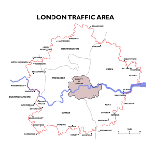
The London Traffic Area was established by the London Traffic Act 1924 to regulate the increasing amount of motor traffic in the London area. The LTA was abolished in 1965 on the establishment of the Greater London Council.

The Greensand Ridge, also known as the Wealden Greensand is an extensive, prominent, often wooded, mixed greensand/sandstone escarpment in south-east England. Forming part of the Weald, a former dense forest in Sussex, Surrey and Kent, it runs to and from the East Sussex coast, wrapping around the High Weald and Low Weald. It reaches its highest elevation, 294 metres (965 ft), at Leith Hill in Surrey—the second highest point in south-east England, while another hill in its range, Blackdown, is the highest point in Sussex at 280 metres (919 ft). The eastern end of the ridge forms the northern boundary of Romney Marsh.

Cholesbury Camp is a large and well-preserved Iron Age hill fort on the northern edge of the village of Cholesbury in Buckinghamshire, England. It is roughly oval-shaped and covers an area, including ramparts, of 15 acres (6.1 ha), and measures approximately 310 m (1,020 ft) north-east to south-west by 230 m (750 ft) north-west to south-east. The interior is a fairly level plateau which has been in agricultural use since the medieval period. The hill fort is now a scheduled ancient monument.

Codsheath was a hundred, a historical land division, in the county of Kent, England. It occupied the eastern part of the Lathe of Sutton-at-Hone, within in the west division of Kent. Codsheath was also recorded as "Codsede" in ancient records. Today the area that was the Codsheath Hundred is part of the Sevenoaks District of Kent that includes the town of Sevenoaks and surrounding area. The Hundred of Codsheath was included in the Domesday Book of 1086, that records it as having 203 houses, 44 in Sundridge and 159 in Otford. The River Darent flowed through the Codsheath Hundred, generally in a northeast direction. Several watermills were constructed on the river within the hundred, in the villages of Sundridge, Otford, Shoreham and Chevening.
