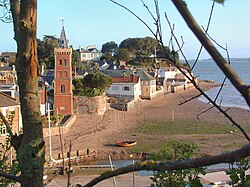
Lympstone is a village and civil parish in East Devon in the English county of Devon. It has a population of 2,100.[1] There is a harbour on the estuary of the River Exe,[2] lying at the outlet of Wotton Brook between cliffs of red breccia.[3] The promontory to the north of the harbour is topped by a flat pasture, Cliff Field, that is managed by the National Trust and used for football matches and other local events.
It is known locally for Peter's Tower, an Italianate riverfront brick clock tower built around 1885 by W.H. Peters as a memorial to his wife,[4] and for its tradition of residents drying washing on the foreshore.[5] The riverside houses back directly on to the shore, with no continuous seawall, and the passageways between them to the beach are equipped with metal flood gates that are closed by residents when they are warned of high tides by a local alert network.[6]
Lympstone celebrates the annual tradition of the Furry Dance on the first Saturday of August. The Furry Dance attracts thousands of visitors to the village each year, with various events throughout the day preceding the dance. Dozens of villagers perform the traditional dance in fancy dress, accompanied by a brass band, processing from the centre of the village to The Saddlers Arms and back again.
Lympstone Manor (formerly Courtlands House) is an historical house which now provides hotel and restaurant accommodation.
There is archaeological evidence of human settlement from as early as the third century A.D. A roman coin from the reign of Gordian III (A.D. 238-244) was found in 1879 in the churchyard, and later a silver Antoninianus of Phillip I (A.D. 244-249) was found near Underhill.[7]
The first record of Lympstone is in the Domesday Book, where it is recorded:
Leuestona. Richard son of Earl Giselbert has a manor called Leuestona which saward held on the day on which King Edward was alive and dead and it rendered geld for one hide and one virgate. This can be ploughed by eight ploughs. William Capra holds this of Richard. Of this ten villeins and six bordards and two serfs return eight pounds to William in ferm. And when Richard (received) this manor it was worth ten pounds.[8]
In 1329, we have the first record of the church in Lympstone when the rector, Richard de Doune, petitioned Bishop Grandisson to delay consecration of the 'partially rebuilt' church. Bishop Stafford consecrated a new church, the Church of the Nativity of the Blessed Virgin Mary, on the 24th September 1409. The majority of this church would be rebuilt between 1864 and 1867 - only the tower, the chancel arch, the two angels in the sanctuary and the north arcading are remaining of the original church.[7]
The manor of Lympstone was held by multiple families throughout its history. It was held for a number of years by the Abermarle family. From around 1327, the Dynham family bought the manor and took up residence at Nutwell court, then a fortified castle. In 1371, John Dynham (1318–1383) obtained a licence for a chapel at Nutwell. In 1459, Edward, Earl of March, with the Duke of Warwick and the Neville family, took refuge at either the hunting lodge at Gulliford, or the castle at Nutwell, before John Dynham, 1st Baron Dynham financed a ship which took the fleeing royal party to Calais.[9]
Lympstone has had a long tradition of smuggling and piracy. John Nutt was born in Lympstone and appears to have led a number of operations while based in Lympstone. A number of underground tunnels existed, and may still exist underneath Lympstone. There are oral records of such tunnels leading from Sowden End Cliffs to Sowden House, and from Nutwell Beach up to Gulliford Farm. A number of houses in Lympstone have been recorded to have hiding places for contraband.[7] Smuggling died out in Lympstone by the mid-19th Century.
By the late 16th Century, Lympstone began to be associated with the Drake family. Sir Francis Drake, the famous admiral, perhaps visited the hunting lodge at Gulliford and inspiring the Californian Poppy fresco that survives. The manor of Lympstone was later leased to Sir Francis Drake, third baronet. He was the son-in-law of Sir Henry Pollexfen, Chief Justice of the Common Pleas - who bought Nutwell court in 1685.[7] The manor, and Nutwell - reunited, were eventually passed to the third baronet's daughter, Anne Pollexfen-Drake who married George Augustus Elliott, 1st Baron Heathfield in 1748.
In 1802, the Lord of the Manorship was formally bought by the 2nd Baron Heathfield. He was succeeded by his nephew, Thomas Trayton Fuller, who adopted the surnames Elliott and Drake. The Fuller-Elliott-Drake family would remain Lords of the Manor until 1938, with the death of Lady Seaton.[7] With the threat of war looming, concerns over the inheritance of the manor were not considered, and claims by both her cousin and godson appear to have not led to any inheritance.
The village has four pubs. They have been well-recorded. In 1826, the local magistrate appeared before the village Select Vestry and stated that "greater irregularities were practiced in the two Public Houses in this Village than anywhere else in the neighbourhood."[7]
On 12th June 1833, a fire broke out at a fisherman's cottage when a frying pan being used to cook mackerel set the chimney alight. The thatched roof caught on fire and spread quickly, eventually destroying 58 houses (including the Parish Poor House), and rendering nearly 250 people homeless.[7]
Modernisation of village amenities were first proposed in 1871, when the village set up its own sanitary committee. Recommendations were made for a comprehensive sewer system, but this was met with widespread disapproval. By September 1880 the sewers had been built.[7] In 1884, suggestions of petroleum lamps were made for the village, and were summarily dismissed. In 1893, 12 lamps were finally installed.[7]
The 20th Century has seen a wave of development to the village. The end of manorial rule allowed for the development of newer housing estates in Upper Lympstone. in 1940, land north of Nutwell was sold to develop the Commando Training Centre Royal Marines (CTCRM).
Sport and leisure
Sailing and other watersports are a major part of village life. The village has a sailing club, established in 1947 and based in the harbour.[10]
Lympstone AFC were formed in 1895, they have 2 sides in the Devon & Exeter Football League & 16 youth teams (7-16) in the Exeter & District youth league.[11]
The Exeter–Exmouth cycle route passes through the village. The cycle route is popular for commuters and recreational cyclists. Prior to the opening of the cycle route the only direct route to cycle between Exmouth and Exeter was along the busy A376. The cycle route passes through the centre of the village bringing custom to the shop, cafe and pubs and adds to the vibrancy and sustainability of the village centre and its businesses. Despite this, a minority group is currently campaigning to change the route and are concerned it affects the village centre and could be made safer for users and villagers.
The 1st Lympstone Sea Scouts Group celebrated its centenary in 2012. It currently has flourishing Scout and Cub sections. It meets in the Scout HQ on Cliff Field.
The village has multiple public open spaces. Cliff Field is often used for football matches. Candy's field contains a playground, basketball court and tennis courts. Opposite the church, a new village green has recently been landscaped.
Lympstone has a number of societies and organisations. The Lympstone Players were established in 1943 and currently have over 70 members.[12] There is also an art group, film society, garden club, and youth club - to name a few.
John Nutt (before 1600 – after 1632) was an English pirate. He was one of the more notorious brigands of his time raiding the coast of southern Canada and western England for over three years before his capture by Sir John Eliot in 1623. His arrest and conviction caused a scandal in the English court, after Nutt paid Eliot £500 in exchange for a pardon, and was eventually released by Secretary of State George Calvert.
Henry Pollexfen, Lord Chief Justice of the Common Pleas lived in Lympstone from 1685, and is buried in neighbouring Woodbury.
Francis Augustus Eliott, 2nd Baron Heathfield, British Army officer, and son of the revolutionary general, George Augustus Eliott, inherited the lease of Lord of the Manor of Lympstone from his uncle, alongside the Manor at Nutwell (then in Lympstone). Lord Heathfield spent the next 5 years (1798–1803) rebuilding Nutwell Court to its current appearance, whilst living at nearby Gulliford Farm.
Edward Shortland, New Zealand Medical Doctor, was born at Courtland’s House in 1812.
George Manson, Scottish Watercolourist, died in Lympstone and is buried at Gulliford Dissenter’s Burial Ground.
Rear-Admiral Percy Pitt Luxmore lived in Lympstone in the 1870s.[14]
Dorothy Rockfort, an early Hollywood screenwriter, was born in Lympstone before her family emigrated, via Canada, to California.
William Brook Hallett, JP Esq., early proponent of the Young Farmers’ Club, chairman of the National Farmers Union, and senior government rationing advisor during the Second World War, was born at Gulliford Farm. He would later chair numerous committees in Devon, including as Chair of the Devon Hospitals Board, and neighbouring village Woodbury’s Parish Council. Hallett was a cousin of Elisabeth Fuller-Elliott-Drake, Baroness Seaton.[15]
Col. Thomas Hussey lived at Highcliffe and died in Lympstone in 1894. His sister, Lady Mary Chetwynd, widow of the 6th Viscount Chetwynd, also lived here until her death in 1901.
Alastair Blair, first-class cricketer, died in Lympstone.
Theophilus Rhys-Jones (d. 1959), was the headmaster of St Peter's Preparatory School, Harefield, Lympstone,[16][17] and paternal grandfather of Sophie, Duchess of Edinburgh[18]
↑Hicks, Michael (2004). "Dynham, John, Baron Dynham (c.1433–1501)". Oxford Dictionary of National Biography (online ed.). Oxford University Press. doi:10.1093/ref:odnb/50234.
This page is based on this Wikipedia article Text is available under the CC BY-SA 4.0 license; additional terms may apply. Images, videos and audio are available under their respective licenses.