
Dartmoor is an upland area in southern Devon, South West England. The moorland and surrounding land has been protected by National Park status since 1951. Dartmoor National Park covers 954 km2 (368 sq mi).

The River Dart is a river in Devon, England, that rises high on Dartmoor and flows for 75 kilometres (47 mi) to the sea at Dartmouth.

South Hams is a local government district on the south coast of Devon, England. Its council is based in the town of Totnes, although the largest town is Ivybridge. The district also contains the towns of Dartmouth, Kingsbridge and Salcombe and numerous villages and surrounding rural areas.

Buckfastleigh is a market town and civil parish in Devon, England situated beside the Devon Expressway (A38) at the edge of the Dartmoor National Park. It is part of Teignbridge and, for ecclesiastical purposes, lies within the Totnes Deanery. It is 18 miles east-northeast of Plymouth, 20 miles southwest of Exeter and has a population of 3,661. It is a centre of tourism and is home to Buckfast Abbey, the South Devon Railway, the Buckfastleigh Butterfly Farm and Otter Sanctuary, the Tomb of Squire Richard Cabell and The Valiant Soldier.

The River Teign is a river in the county of Devon, England. It is 31 mi (50 km) long and rises on Dartmoor, becomes an estuary just below Newton Abbot and reaches the English Channel at Teignmouth.

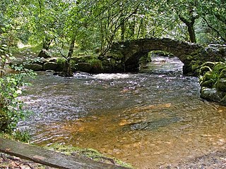
Dartmeet is a popular tourist spot in the centre of Dartmoor, Devon, England at grid reference SX672731.

The Saxtons River is a 22.9-mile-long (36.9 km) river in the U.S. state of Vermont, a tributary of the Connecticut River. Its watershed covers 78 square miles (200 km2) and a range in altitude of 1,800 feet (550 m); land use is about 80% forested and 3% agricultural, and the upper river supports wild brook trout and brown trout, while Atlantic salmon occur but are usually limited to the area below Twin Falls on the lower river.

The River Taw in England rises at Taw Head, a spring on the central northern flanks of Dartmoor, crosses North Devon and at the town of Barnstaple, formerly a significant port, empties into Bideford Bay in the Bristol Channel, having formed a large estuary of wide meanders which at its western end is the estuary of the River Torridge.

Ashburton railway station is a closed railway station situated in the town of Ashburton in Devon, England. It was the terminus of a branch line from Totnes.

The River Lew can refer to either of two short rivers that lie close to each other in Devon, England.
The River Bovey rises on the eastern side of Dartmoor in Devon, England, and is the largest tributary to the River Teign. The river has two main source streams, both rising within a mile of each other, either side of the B3212 road between Moretonhampstead and Postbridge, before joining at Jurston.

The East Webburn is a stream in the Dartmoor moors in Devon in south-west England. It rises on the western side of the moors flowing off the west side of Hameldown ridge. Its source is less than 1 kilometre south west of Grimspound Bronze Age settlement. It flows south past Widecombe-in-the-Moor and joins the West Webburn River at Lizwell Meet in Oakmoor Wood. These combined streams then join the River Dart close to the village of Holne.

The West Webburn is a stream on Dartmoor in Devon in south-west England. It rises on the eastern side of the moors flowing off the east side of Hameldown Ridge. Its source is extremely close to the Grimspound Bronze Age settlement, and it was probably the main source of water for the settlement. It flows south, going past Widecombe-in-the-Moor, and joins the East Webburn River at Lizwell Meet in Oakmoor Wood. These combined streams then join the River Dart at Buckland Bridge close to the village of Holne.
The West Dart River is one of the two main tributaries of the River Dart in Devon, England.

Hexworthy is a hamlet on Dartmoor, in Devon, England. It lies on the West Dart River a mile upstream from Dartmeet. Historically in the parish of Lydford, since 1987 it has been in the civil parish of Dartmoor Forest.

The Ashburton River / Hakatere is a river in the Canterbury region of New Zealand, flowing across Mid Canterbury from the Southern Alps to the Pacific Ocean. The official name of the river was amended to become a dual name by the Ngāi Tahu Claims Settlement Act 1998. It has been identified as an Important Bird Area by BirdLife International because it supports breeding colonies of the endangered black-billed gull.

Dartmouth Harbour is a natural port located in Dartmouth, Devon, England. It is situated at the mouth of the River Dart on the English Channel. Bayard's Cove Fort is a small fort, which was built to defend the harbour's entrance. The crafts which dock at the port are mainly local fishing vessels, naval ships and luxury yachts; warships routinely visit the harbour. The River Dart is navigable from Dartmouth to the old weir location at Totnes.

West Buckfastleigh is a small civil parish in the South Hams district, on the eastern border of Dartmoor in Devon, England. Situated within the parish are the village of Scorriton and the hamlets of Michelcombe and Combe. In 2011 it had a population of 301.
Rippon Tor is a striking tor on eastern Dartmoor, in England, that stands at 473 metres (1,552 ft) above sea level. It has three cairns, of which are some of Dartmoor's largest, a triangulation pillar, and several rock piles that overlook the northern high moors near Fernworthy Forest and Great Mis Tor. Field boundaries surround the tor.
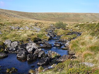
This article describes the geology of Dartmoor National Park in Devon, in south-west England. Dartmoor gained national park status in 1951 but the designated area of 954 km2 (368 sq mi) extends beyond the upland of Dartmoor itself to include much of the surrounding land, particularly in the northeast. The geology of the national park consists of a 625 km2 (241 sq mi) core of granite intruded during the early Permian period into a sequence of sedimentary rocks originating in the Devonian and Carboniferous periods. These rocks were faulted and folded, sometimes, intensely, during the Variscan orogeny. Thermal metamorphism has also taken place around the margins of the granite pluton altering the character of the sedimentary rocks whilst mineral veins were emplaced within the granite. A small outlier of Palaeogene sediments occurs on the eastern boundary of the national park.

