River Dart

Last updated • 5 min readFrom Wikipedia, The Free Encyclopedia

River Dart
RiverDart.jpg
Location
Country England
County Devon
Physical characteristics
Source West Dart
  locationLower White Tor
  elevation450 m (1,480 ft)
2nd source East Dart
  locationKit Rock, Whinney's Down
  elevation510 m (1,670 ft)
Source confluence 
  locationDartmeet
  elevation210 m (690 ft)
Mouth English Channel
  coordinates
50°20′33″N3°33′51″W / 50.34250°N 3.56417°W / 50.34250; -3.56417
  elevation
0 m (0 ft)
Length75 km
Discharge 
  locationAustins Bridge, Buckfastleigh
  average11.04 m3/s (390 cu ft/s)
  maximum40 m3/s (1,400 cu ft/s)
Dartmouth and Kingswear Castles guard the mouth of the River Dart Dartmouth Kingswear Castle.jpg
Dartmouth and Kingswear Castles guard the mouth of the River Dart

The River Dart is a river in Devon, England, that rises high on Dartmoor and flows for 75 kilometres (47 mi) to the sea at Dartmouth. [1]

Contents

Name

Most hydronyms in England derive from the Brythonic language (from which the river's subsequent names ultimately derive from an original Celtic etymology. As the lower stretches of the river are still covered in ancient oak woodlands, it is accepted that the first element derives from *Dar-, meaning oak (derow, Welsh derw). [2] However the second element (evident in the hard consonantal termination of Dar-t) is less certain, with postulated etymologies from Darwent / Derventio (Sacred place of Oak) or Darnant / Darant (Oak stream).

The Ravenna Cosmography records a number of Latinised names for the area, Devionisso Statio and Deventiasteno may represent corrupted doublets of a Statio (Station) on a river named Derventio. [3] Although the name Derventio is otherwise unattested for the river, it is an established etymology throughout Britain, found at the River Darent, Derwentwater, and a number of rivers named Derwent. [4] Anna Eliza Bray recorded that a version of the name, Darant was still in common usage as late as 1832. [5]

Watercourse

The river begins as two separate branches (the East Dart and West Dart), which join at Dartmeet. The paths along these rivers offer very attractive walking, and there are several small waterfalls. The rivers are crossed by a number of clapper bridges, notably at the hamlet of Postbridge.

After leaving the moor, the Dart flows southwards past Buckfast Abbey and through the towns of Buckfastleigh, Dartington and Totnes. At Totnes, where there is a seventeenth-century weir (rebuilt in the 1960s), [6] it becomes tidal, and there are no bridges below the town.

The River Dart showing the lower part of the fish ladder near Buckfastleigh Dart at Salmon leap 2.JPG
The River Dart showing the lower part of the fish ladder near Buckfastleigh

A passenger ferry operates across the river from the village of Dittisham to a point adjacent to the Greenway Estate. Formerly the home of the crime writer Agatha Christie, this has views across the river, and the house and gardens are now owned by the National Trust and are open to the public. [7]

The entrance to the river from the sea is a rocky entrance with cliffs either side. On the East side Kingswear Castle sits very close to the water's edge, and on the west side Dartmouth Castle is built on a rocky promontory at sea level. The castles once operated a defensive chain across the estuary, which was raised at dusk to destroy enemy ships attempting to attack the harbour.

Crossings

The River Dart facing upstream at Totnes, with Totnes Bridge in the background The River Dart at Totnes.jpg
The River Dart facing upstream at Totnes, with Totnes Bridge in the background

The flooded ria that forms the lower reaches of the Dart, with its deep water and steeply sloping valley sides, is a considerable barrier to crossing traffic. There are no bridges below Totnes.

At the mouth of the river, it separates the communities of Dartmouth and Kingswear. There have been proposals to bridge the river here, but these have come to nothing. Instead the two places are linked by, in order going upstream, the Lower Ferry, Passenger Ferry and Higher Ferry. The Lower and Higher ferries both carry vehicles, the Higher one linking the A379 road.

Some 2.5 miles (4.0 km) upstream of Dartmouth, the Greenway Ferry carries pedestrians across the river from the village of Dittisham to Greenway Quay. [7]

A further 5 miles (8.0 km) upstream is Totnes, where the river is spanned by two road bridges, a railway bridge and a footbridge over. Totnes Bridge is the nearest bridge to the sea and is a road bridge built in 1826–1828 by Charles Fowler. Some 1,000 feet (300 m) upstream is Brutus Bridge, constructed in 1982 as part of a road traffic-relief scheme and carrying the concurrent A385 and A381 roads. A further 0.5 miles (0.80 km) upstream, the railway bridge carries the National Rail Exeter to Plymouth line over the river. Immediately upstream of the railway bridge is a footbridge, built in 1993 to provide access to the Totnes (Riverside) terminus of the South Devon Railway. [8] [9] [10]

Dartmouth Harbour, with Kingswear in the background, and river cruise boats alongside Dartmouth Town Jetty Dartmouth.boats.750pix.jpg
Dartmouth Harbour, with Kingswear in the background, and river cruise boats alongside Dartmouth Town Jetty

The lower section of the River Dart forms Dartmouth Harbour, a deep water natural harbour with a long history of maritime usage. In modern times, the port's commercial activity has declined, but it is still a busy port for local fishing vessels and a wide variety of yachts and other private boats. Several local companies specialise in shipbuilding and repairs to small tonnage craft. [11]

Dartmouth is also the home of the Britannia Royal Naval College and as a result is routinely visited by sizeable naval ships. Smaller naval tenders are often seen carrying out training exercises in the harbour and river. Large cruise ships are occasional visitors, with the largest visitor to date being the MV Royal Princess (30,277  GT). [11] [12]

Upstream, the Dart is navigable to seagoing vessels as far as the weir in Totnes. The river almost dries out for 2 miles (3.2 km) below Totnes at spring tide low water, but vessels drawing up to 3 foot (0.91 m) can proceed to Totnes from one and a half hours after low water. Above the weir, the river is navigable only to small craft such as kayaks and canoes. [13]

Aerial view of the Dart estuary. Dart estuary 2.jpg
Aerial view of the Dart estuary.

Several companies operate trips on the river, including Dart Pleasure Craft Limited, who also trade as River Link and operate the passenger ferry between Dartmouth and Kingswear. These include cruises from Dartmouth to Totnes, which can be combined with journeys on the Paignton and Dartmouth Steam Railway and an open-top bus between the towns of Totnes and Paignton to create a circular trip. [14]

The harbour and port are both leisure boating locations, and several marinas and boat yards are located on the river. The Port of Dartmouth Royal Regatta takes place annually over three days at the end of August.

Canoeing and kayaking

Kayakers playing on a wave under Newbridge NewbridgeRiverDart.jpg
Kayakers playing on a wave under Newbridge

The upper reaches of Dartmoor, especially those on the Dart, are a focal point for whitewater kayakers and canoeists. The best known sections of the river are:

Sections of the East and West Dart above Dartmeet, as well as the Webburn are also paddled when conditions permit. This is somewhat controversial, as riparian landowners and those responsible for local fisheries maintain that the East and West Dart should not be paddled.

The lower reaches of the Dart, including the estuary are suitable for flat water touring.

The weir at Totnes River Dart Weir at Totnes.jpg
The weir at Totnes

See also

Related Research Articles

<span class="mw-page-title-main">Dartmouth, Devon</span> Town in England

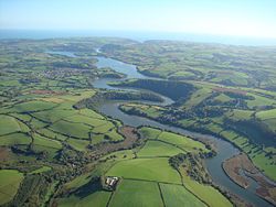
Dartmouth is a town and civil parish in the English county of Devon. It is a tourist destination set on the western bank of the estuary of the River Dart, which is a long narrow tidal ria that runs inland as far as Totnes. It lies within the South Devon Area of Outstanding Natural Beauty and South Hams district, and had a population of 5,512 in 2001, reducing to 5,064 at the 2011 census. There are two electoral wards in the Dartmouth area. Their combined population at the above census was 6,822.

<span class="mw-page-title-main">South Hams</span> Local government district in Devon, England

South Hams is a local government district on the south coast of Devon, England. Its council is based in the town of Totnes, although the largest town is Ivybridge. The district also contains the towns of Dartmouth, Kingsbridge and Salcombe and numerous villages and surrounding rural areas.

<span class="mw-page-title-main">Buckfastleigh</span> Town and civil parish in Devon, England

Buckfastleigh is a market town and civil parish in Devon, England situated beside the Devon Expressway (A38) at the edge of the Dartmoor National Park. It is part of Teignbridge and, for ecclesiastical purposes, lies within the Totnes Deanery. It is 18 miles east-northeast of Plymouth, 20 miles southwest of Exeter and has a population of 3,661. It is a centre of tourism and is home to Buckfast Abbey, the South Devon Railway, the Buckfastleigh Butterfly Farm and Otter Sanctuary, the Tomb of Squire Richard Cabell and The Valiant Soldier.

<span class="mw-page-title-main">Dartmeet</span> Confluence of East and West Dart in Devon, England

Dartmeet is a popular tourist spot in the centre of Dartmoor, Devon, England at grid reference SX672731.

PS <i>Kingswear Castle</i>

PS Kingswear Castle is a steamship. She is a coal-fired river paddle steamer, dating from 1924 with engines from 1904. After running summer excursions on the River Medway and the Thames for many years she returned to the River Dart in Devon in December 2012 to run excursions from 2013 onwards on the river she was built on and for. Kingswear Castle is listed as part of the National Historic Fleet of ships of "Pre-eminent National Significance".

<span class="mw-page-title-main">Dartmouth Steam Railway</span> Heritage railway line in Devon, England

The Dartmouth Steam Railway, formerly known as the Paignton and Dartmouth Steam Railway, is a 6.7-mile (10.8 km) heritage railway on the former Great Western Railway branch line between Paignton and Kingswear in Devon, England. Much of the railway's business is from summer tourists from the resorts of Torbay, who travel to Kingswear, where the Dartmouth Passenger Ferry takes them across the River Dart to Dartmouth.

<span class="mw-page-title-main">South Devon Railway (heritage railway)</span> Heritage railway in Devon, England

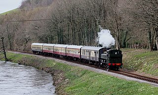
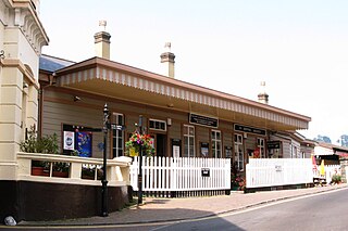
The South Devon Railway (SDR) is a 6.64-mile (10.69 km) heritage railway from Totnes to Buckfastleigh in Devon. Mostly running alongside the River Dart, it was initially known as the Dart Valley Railway. The railway is now operated by the South Devon Railway Trust, a registered charity.

Kingswear is a village and civil parish in the South Hams area of the English county of Devon. The village is located on the east bank of the tidal River Dart, close to the river's mouth and opposite the small town of Dartmouth. It lies within the South Devon Area of Outstanding Natural Beauty, and has a population of 1,332, reducing to 1,217 at the 2011 census.

<span class="mw-page-title-main">Dartmouth and Torbay Railway</span>

The Dartmouth and Torbay Railway was a broad gauge railway linking the South Devon Railway branch at Torquay with Kingswear in Devon, England. It was operated from the outset by the South Devon Railway.

<span class="mw-page-title-main">The Loop, River Dart</span> Section of the River Dart, Dartmoor, England

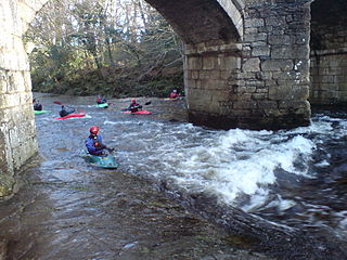
The Loop is a section of the River Dart, Dartmoor, also known as the Dart Loop.

<span class="mw-page-title-main">Dartmouth railway station</span>

Dartmouth railway station was a booking office for train tickets located on the quayside of Dartmouth in the English county of Devon. While there has never been a railway line at the site, it was possible to book through tickets to and from Dartmouth via the office, accessing trains by travelling on Dartmouth Passenger Ferry to or from Kingswear railway station on the opposite bank of the River Dart. Accordingly, the office was classed as a "railway station" for ticketing purposes if purchasing an integrated ticket combining rail and ferry travel.

<span class="mw-page-title-main">Dartmouth Passenger Ferry</span>

The Dartmouth Passenger Ferry, also known as the Dartmouth Steam Railway and Riverboat company, is a passenger ferry that crosses the River Dart in the English county of Devon. It is one of three ferries that cross the tidal river from Dartmouth to Kingswear, the others being the Higher Ferry and the Lower Ferry. The 630-mile (1,010 km) long South West Coast Path crosses the Dart on either the Lower or Passenger ferries.

<span class="mw-page-title-main">River Link (Devon)</span> Ferry, cruise boat and bus operator, based in Devon

River Link is a ferry, cruise boat, and bus operator, based in Devon, England. The company is owned by Dart Valley Railway plc, who also own and operate the Dartmouth Steam Railway.

<span class="mw-page-title-main">Dittisham</span> Village in Devon, England

Dittisham is a village and civil parish in the South Hams district of the English county of Devon. It is situated on the west bank of the tidal River Dart, some 2 miles (3.2 km) upstream of Dartmouth.

MV <i>Devon Belle II</i>

The MV Dartmouth Princess is a single screw passenger vessel, operating on the River Dart in South Devon, United Kingdom. She is mainly used on the Dartmouth Passenger Ferry service from Dartmouth to Kingswear, where she runs year-round as the main vessel.

MV <i>Humphrey Gilbert</i> Single-screw passenger vessel

The MV Edgecumbe Belle is a single screw passenger vessel, operating from Dartmouth, Devon, UK to Kingswear for Dart Pleasure Craft Limited.

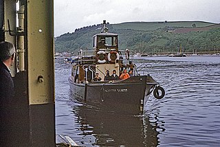
The River Dart Steamboat Co Ltd (RDSC) and its predecessors, the Dartmouth Steam Packet Company and the Dartmouth and Torbay Steam Packet Company, were the major ferry and excursion boat operators on the River Dart in South Devon for 120 years, until the company's demise in 1976. The company was famous for its distinctive paddle steamers, which were a familiar sight on the river until the late 1960s.

<span class="mw-page-title-main">Greenway Halt railway station (Devon)</span> Heritage railway station in Devon, England

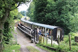
Greenway Halt railway station is a small railway station on the Dartmouth Steam Railway, a heritage railway in Devon, England. It is situated near the northern end of the 495-yard long Greenway Tunnel and convenient for visitors to the Greenway Estate, the historic home of Agatha Christie.

<span class="mw-page-title-main">Dartmouth Harbour</span> Natural harbour on the River Dart in Devon, England

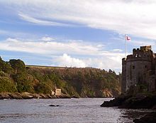
Dartmouth Harbour is a natural port located in Dartmouth, Devon, England. It is situated at the mouth of the River Dart on the English Channel. Bayard's Cove Fort is a small fort, which was built to defend the harbour's entrance. The crafts which dock at the port are mainly local fishing vessels, naval ships and luxury yachts; warships routinely visit the harbour. The River Dart is navigable from Dartmouth to the old weir location at Totnes.

References

  1. "Devon;Nature Features: River Dart Ramble". BBC. Retrieved 23 January 2021.
  2. ISBN   0-19-852758-6 Oxford Dictionary of British Place Names
  3. Todd, Malcolm (23 June 2014). The South West to 1000 AD. ISBN   9781317871637 . Retrieved 29 April 2021.
  4. Whaley, Diana (2006). A dictionary of Lake District place-names. Nottingham: English Place-Name Society. pp. lx, 423 p.95. ISBN   0904889726.
  5. Bray (Anna Eliza), Mrs (1836). A Description of the Part of Devonshire Bordering on the Tamar and the Tavy ... Vol. 1. p. 16. Retrieved 29 May 2013 via Google Books.
  6. "Swallowfield Weir, Totnes". Devon and Dartmoor Historic Environment Record. Historic England. Retrieved 8 July 2016.
  7. 1 2 "Dittisham Departures". Greenway Ferry Service. Archived from the original on 15 May 2008. Retrieved 24 September 2008.
  8. Bridget Cherry & Nikolaus Pevsner (1989). The Buildings of England — Devon. Harmondsworth: Penguin. pp. 866–875. ISBN   0-14-071050-7.
  9. Hawkins, Michael (1988). Devon Roads: An illustrated survey of the development and management of Devon's highway network. Exeter: Devon Books. p. 52. ISBN   0-86114-817-7.
  10. Taylor, Alan; Treglown, Peter (May 1999). South Devon Railway - A Visitors Guide. South Devon Railway Trust. pp. 23–28.
  11. 1 2 "Commercial Vessels Guide". Dart Harbour & Navigation Authority. Archived from the original on 12 September 2008. Retrieved 25 September 2008.
  12. "Visiting Ships". Dart Harbour & Navigation Authority. Retrieved 25 September 2008.
  13. "Sailing Directions". Dart Harbour & Navigation Authority. Retrieved 25 September 2008.
  14. "River Trips". Dart Harbour & Navigation Authority. Retrieved 25 September 2008.
  15. 1 2 Howard., Mark Rainsley, BCU Access and. "River Dart - New Bridge to Holne Bridge - the 'Loop' - South West - England - Rivers - The UK Rivers Guidebook". ukriversguidebook.co.uk.{{cite web}}: CS1 maint: multiple names: authors list (link)
  16. Access., Mark Rainsley, also Chris Green, Stuart Woodward and Dart. "River Dart - Holne Bridge to Buckfastleigh - South West - England - Rivers - The UK Rivers Guidebook". ukriversguidebook.co.uk.{{cite web}}: CS1 maint: multiple names: authors list (link)