Dartmouth Harbour

Last updated

Dartmouth Harbour
Dartmouth.boats.750pix.jpg
Dartmouth Harbour, with Kingswear in the background, and River Dart cruise boats alongside Dartmouth Town Jetty.
Devon UK relief location map.jpg
Red pog.svg
Dartmouth Harbour
Location United Kingdom, Devon County
Coordinates 50°21′06″N3°34′40″W / 50.35167°N 3.57778°W / 50.35167; -3.57778 Coordinates: 50°21′06″N3°34′40″W / 50.35167°N 3.57778°W / 50.35167; -3.57778 [1]
River sources Dart River
Basin  countries United Kingdom
Settlements Dartmouth
References Dartmouth Harbour

Dartmouth Harbour (also Dart Harbour) is a natural port located in Dartmouth, Devon, England. It is situated at the mouth of the River Dart on the English Channel. [2] Bayard's Cove Fort is a small fort, which was built to defend the harbour's entrance. The crafts which dock at the port are mainly local fishing vessels, naval ships and luxury yachts; warships routinely visit the harbour. [3] The River Dart is navigable from Dartmouth to the old weir location at Totnes.

Contents

Geography

The harbour is located at the mouth of the River Dart (the name 'Dart' is Brythonic Celtic meaning 'river where oak trees grow'), [4] which rises high on Dartmoor, and enters the sea at Dartmouth. The river begins as two separate branches (the East Dart and West Dart), which join at Dartmeet. The rivers are crossed by a number of clapper bridges, notably at the hamlet of Postbridge. At Totnes a weir (of the 17th century vintage rebuilt in the 1960s) has been constructed across the river. The river reach between the Totnes weir and the port is tidal and hence navigable, and there are no bridges across the river in this reach. [3] The banks of the lower Dart are covered in ancient woodland of native oak. [5] The entrance to the river from the sea is rocky with cliffs on either side. The lower section of the River Dart forms the Dartmouth Harbour, a deep water natural harbour with a long history of maritime usage. [6]

Map of Dartmouth Dartmouth map.png
Map of Dartmouth

The low coast line rises gradually. The harbour entrance is 5 miles (8.0 km) to the south west of Berry Head. On the east side, Kingswear Castle is located very close to the water's edge, and on the west side, Dartmouth Castle is built on a rocky promontory. Visible landmarks from the entrance to the harbour are: the outline of Dartmoor Range which has granite peaks of Hayton (rugged peak); Rippon with single carn 1,525 feet (465 m); Stoke Fleming Church built on a high ground, about 1.75 miles (2.82 km) to the west of the entrance; and Mewstone, a rocky islet about 0.75 miles (1.21 km) east of the entrance. Dartmouth is located on the right bank of the estuary. [7]

Brownstone Battery foundation overlooking Mew Stone. Brownstone Battery, foundation overlooking Mew Stone - geograph.org.uk - 1011144.jpg
Brownstone Battery foundation overlooking Mew Stone.

The tide rise is about 14 feet (4.3 m) and the patent slips are of 250 feet (76 m) and 450 feet (140 m) length, capable of berthing large vessels. Navigation up to Totnes is possible for 10 miles (16 km) along the River Dart. [7] Blackstone rock, 8 feet (2.4 m) above high water level, is a landmark for ships to bypass shoals at the entrance. Entrance to the bay is 220 yards (200 m) wide between the rocks but as it widens into the harbour it provides enough room for vessels of any draught and fairly large capacity to berth safely. However, during rough weather it is dangerous to navigate through the entrance due to the rough rocky faces, and for miles without any sand bars for protection.

Features

Sandquay shipyard within the harbour. Sand Quay, Dartmouth. - geograph.org.uk - 900598.jpg
Sandquay shipyard within the harbour.

The port is available 24 hours a day. Up to the minute tidal information is available from Dart Harbour administration, based on UK Hydrographic Office data. It is a very busy port with about 2,800 moorings including 200 visitors’ moorings. Dart Harbour administration has a specific Moorings’ Policy to help guide its moorings decisions. [3] It is said that in modern times, the port's commercial activity has declined, but it is still a busy port for local fishing vessels and a wide variety of yachts and other private boats and cruise ships. Several local companies specialise in shipbuilding and repairs to small tonnage craft. [6] Large cruise ships are occasional visitors; the largest visitor to date was the MS The World, a residential cruise ship as well as Sailing Yacht EOS (built in Bremen, Germany) before it was delivered to her owner in the Bahamas and another cruise ship, the Le Diamant in September 2012, with MV Minerva visiting on 11 July 2010. [6] [8] Smaller naval Picket Boats and whalers are often seen carrying out training exercises in the harbour and river. The port facility is under the International Ship and Port Facility Security Code (ISPS Code). A bunkering facility is available. Plymouth, Exeter and Bristol airports are easily accessible from the port by local transport. [8]

The light provided on the 85 feet (26 m) tower (above high tide), as of 1871, could be seen over a distance of 11 miles (18 km) in clear weather. Another fixed leading light, 110 feet (34 m) seaward of the first tower is at 70 feet (21 m) above high tide and the two lights together guide the ships to the center of the entrance channel. After passing through the channel between Castle and Kettle points, the fixed light provided at the guard station at the southern end of the town guides ships into the anchorage through the fairway. Red light is flashed to indicate shoals to the north of the harbour and green light is flashed to indicate the shoals over the south point, off "One Gun Point". A day time beacon in the form of a truncated pyramid of 85 feet (26 m) height on the land to the eastern side of the entrance, about 500 feet (150 m) above sea level, is meant to guide ships. [7]

Visitor attractions

Dartmouth Regatta - geograph.org.uk - 645775.jpg
Dartmouth, the marina and the Royal Castle Hotel - geograph.org.uk - 1468086.jpg
Dartmouth Regatta (left); the marina and Royal Castle Hotel (right).

Visitor attractions from the port are the Dartmoor National Park and the Bovey Castle (now a hotel). Good quality produce is available, with some of the best shellfish areas in the whole of the UK, as well as Sharpham Vineyard and Cheese Dairy (for the best of wines), and a hot air balloon over the nearby countryside. The harbour and port are popular leisure boating locations, and several marinas and boat yards are located on the river. The Port of Dartmouth Royal Regatta takes place annually over three days at the end of August.

Mouth of the Dart, two castles - geograph.org.uk - 1011369.jpg
Royal Navy ship at Dartmouth - geograph.org.uk - 79174.jpg
Mouth of the Dart and its two castles (left); Royal Navy ship at Dartmouth (right).

The ancient town around the Dart Harbour town has a long history. [8] Other historical sites at the estuary of Dart are Dartmouth Castle [9] and Kingswear Castle, which is painted white on its front face towards the sea. The castles once operated a defensive chain across the estuary, which was raised at dusk to block enemy ships attempting to attack the harbour. The remains of the operating mechanisms for the chain are still visible in Dartmouth Castle. [10] Dartmouth Castle's artillery blockhouse, dated to 1481, was constructed to protect the harbour. [10] Dartmouth is also the home of the Britannia Royal Naval College (with links to the British Royal family) and as a result is routinely visited by sizable naval ships.

Dartmouth Castle was built to protect the harbour. Dartmouth Castle, from the mouth of the River Dart - geograph.org.uk - 376423.jpg
Dartmouth Castle was built to protect the harbour.

See also

Related Research Articles

Dartmouth, Devon Town in Devon, England

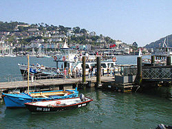
Dartmouth is a town and civil parish in the English county of Devon. It is a tourist destination set on the western bank of the estuary of the River Dart, which is a long narrow tidal ria that runs inland as far as Totnes. It lies within the South Devon Area of Outstanding Natural Beauty and South Hams district, and had a population of 5,512 in 2001, reducing to 5,064 at the 2011 census. There are two electoral wards in the Dartmouth area. Their combined population at the above census was 6,822.

River Dart

The River Dart is a river in Devon, England which rises high on Dartmoor, and releases to the sea at Dartmouth.

South Hams Place in England

South Hams is a local government district on the south coast of Devon, England. Services divide between those provided by its own Council headquartered in Totnes, and those provided by Devon County Council headquartered in the city of Exeter.

PS <i>Kingswear Castle</i>

PS Kingswear Castle is a steamship. She is a coal-fired river paddle steamer, dating from 1924 with engines from 1904. After running summer excursions on the River Medway and the Thames for many years she returned to the River Dart in Devon in December 2012 to run excursions from 2013 onwards on the river she was built on and for. Kingswear Castle is listed as part of the National Historic Fleet of ships of "Pre-eminent National Significance".

Dartmouth Steam Railway

The Dartmouth Steam Railway, formerly known as the Paignton and Dartmouth Steam Railway, is a 6.7-mile (10.8 km) heritage railway on the former Great Western Railway branch line between Paignton and Kingswear in Devon, England. Much of the railway's business is from summer tourists from the resorts of Torbay, who travel to Kingswear, where the Dartmouth Passenger Ferry takes them across the River Dart to Dartmouth.

Kingswear Human settlement in England

Kingswear is a village and civil parish in the South Hams area of the English county of Devon. The village is located on the east bank of the tidal River Dart, close to the river's mouth and opposite the small town of Dartmouth. It lies within the South Devon Area of Outstanding Natural Beauty, and has a population of 1,332, reducing to 1,217 at the 2011 census.

Kingswear Castle

Kingswear Castle is an artillery fort, built to protect Dartmouth harbour in Devon, England. It was constructed between 1491 and 1502 in response to the threat of French attack and was one of the first purpose-built artillery forts in Britain. By the end of the 16th century, however, improvements in the range of artillery weapons had reduced the utility of the castle. It took part in the English Civil War and continued to be armed until the early 18th century, but fell into ruin. Restored as a summer house in 1855, in the 21st century it is managed by the Landmark Trust as a holiday let.

Bayards Cove Fort

Bayard's Cove Fort, also known historically as Berescove or Bearscore Castle, is an English 16th-century artillery blockhouse, built to defend the harbour entrance at Dartmouth in Devon. Constructed in the early part of the century, it had eleven gunports for heavy artillery and was intended to engage enemy vessels that broke past the external defences of the Dartmouth and Kingswear castles. It remained armed during the English Civil War, but was neglected in the 18th century and used for storage. The fort was restored in the late 19th century and is now managed by English Heritage and open to visitors.

River Link

River Link is a ferry, cruise boat, and bus operator, based in Devon, England. The company is owned by Dart Valley Railway plc, who also own and operate the Dartmouth Steam Railway.

MV <i>Cardiff Castle</i>

The MV Cardiff Castle is a twin screw passenger vessel, operating on the River Dart in South Devon, UK, mainly on the cruise / ferry route between Dartmouth and Totnes, but also on circular cruises from Dartmouth, for Dart Pleasure Craft Ltd.

G.H. Riddalls and Sons was a passenger boat operator on the River Dart, in South Devon, England. It operated on the route from Dartmouth to Totnes, on circular cruises from Dartmouth and also ran the ferry service from Dartmouth to Dittisham. The boats were painted with red hulls and white superstructures, and were marketed as the "Red Cruisers".

MV <i>Devon Belle II</i>

The MV Dartmouth Princess is a single screw passenger vessel, operating on the River Dart in South Devon, United Kingdom. She is mainly used on the Dartmouth Passenger Ferry service from Dartmouth to Kingswear, where she runs year-round as the main vessel.

The MV Edgecumbe Belle is a single screw passenger vessel, operating from Mt Edgcumbe and Stonehouse Plymouth running 7 days a week half hour service also carrys Marley the ferry dog.

MV <i>Lady Wakefield</i>

The MV Lady Wakefield is a twin screw passenger vessel, operating between Glenridding, Howtown and Pooley Bridge on Ullswater in the Lake District for Ullswater Navigation and Transit Co, marketed as Ullswater 'Steamers'.

MVSeymour Castle is a river boat sailing for Thames River Cruises of Reading, England as the MV Devon Belle. She is registered by National Historic Ships on the National Register of Historic Vessels, certificate number 1955, and is one of the surviving "Little ships of Dunkirk" from the Dunkirk evacuation in 1940.

The River Dart Steamboat Co Ltd (RDSC) and its predecessors, the Dartmouth Steam Packet Company and the Dartmouth and Torbay Steam Packet Company, were the major ferry and excursion boat operators on the River Dart in South Devon for 120 years, until the company's demise in 1976. The company was famous for its distinctive paddle steamers, which were a familiar sight on the river until the late 1960s.

MV <i>Devonair Belle</i>

MV Devonair Belle was the original name of the MV Dart Explorer, which is a twin-screw passenger catamaran, operating on the River Dart in South Devon, UK, mainly on the circular harbour cruise route from Dartmouth, for Dart Pleasure Craft Ltd.

MV <i>Dartmouth Castle</i>

MV Dartmouth Castle is a passenger ship operating on the River Dart for the Dartmouth Steam Railway and River Boat Company. She is listed on the National Register of Historic Ships

Dart Lifeboat Station

Dart Lifeboat Station is the base for Royal National Lifeboat Institution (RNLI) search and rescue operations at Dartmouth, Devon in England. The present station was opened in 2007 although an earlier lifeboat was stationed in the town from 1878 to 1896. It operates a D class (IB1) inshore lifeboat (ILB).

NCI Froward Point

NCI Froward Point is a busy National Coastwatch Institution (NCI) lookout station at Inner Froward Point at the easterly side of the mouth of the River Dart two miles by coast path from Kingswear in Devon in England. Its twin duties are to maintain an hours of daylight watch over the local coastal area and the South West Coast Path on whose route it lies. With some significant blind spots because of the coastline, NCI Froward Point covers the coastline from Start Point in the West towards Brixham in the East.

References

  1. "Map of Dartmouth Harbour in Devon, United Kingdom".
  2. "The Royal Castle Hotel". The Royal Castle Hotel, Dartmouth, Devon, TQ6 9PS. Retrieved 3 November 2012.
  3. 1 2 3 "Dartmouth Harbour". Official web site of Dartmouth Harbour. Retrieved 3 November 2012.
  4. ISBN   0-19-852758-6 Oxford Dictionary of British Place Names
  5. "Press release on restoring ancient woodland in Dartmoor's valleys". Dartmoor National Park Authority. Archived from the original on 21 October 2007. Retrieved 3 November 2012.
  6. 1 2 3 "Commercial Vessels Guide". Dart Harbour & Navigation Authority. Archived from the original on 12 September 2008. Retrieved 25 September 2008.
  7. 1 2 3 English channel, Admiralty hydrogr. dept (1882). The Channel pilot. Pt. 1. 2nd- ed. (With) Admiralty notices to mariners. Admiralty Hydrographic Department. p.  112 . Retrieved 5 November 2012. Dartmouth Harbour.
  8. 1 2 3 "Visiting Ships and Luxury Yachts". Dartharbour Organization. Archived from the original on 9 November 2012. Retrieved 3 November 2012.
  9. "Dartmouth Castle, Devon". British Premier Heritage website. Retrieved 3 November 2012.
  10. 1 2 Lowry, Bernard (4 March 2008). Fortifications From the Tudors to the Cold War. Osprey Publishing. pp. 126–. ISBN   978-0-7478-0651-6 . Retrieved 5 November 2012.