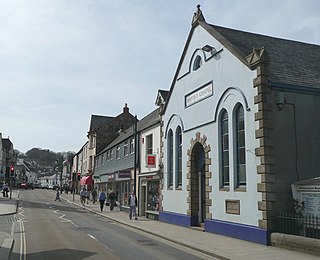
Okehampton is a town and civil parish in West Devon in the English county of Devon. It is situated at the northern edge of Dartmoor, and had a population of 5,922 at the 2011 census. Two electoral wards are based in the town. Their joint population at the same census was 7,500.

Dartmeet is a popular tourist spot in the centre of Dartmoor, Devon, England at grid reference SX672731.

High Willhays, or according to some authorities High Willes, is the highest point on Dartmoor, Devon, at 621 metres above sea level, and the highest point in Southern England.

East Portlemouth is a small Devon village situated at the southern end of the Kingsbridge Estuary, on the south Devon Coast. The population of this parish taken at the 2011 census was 162. The village is sited on a hill giving views to the north to Kingsbridge and on a clear day as far as Dartmoor. There is a small ferry that runs to Salcombe in the opposite side of the estuary, and a beach that is popular with holidaymakers.

Belstone is a small village and civil parish in the West Devon District of Devon, England.

Broadwoodwidger is a village and civil parish in the Torridge district of Devon, England. According to the 2001 census it had a population of 548. The village is just to the north of the A30 road, and is about eight miles east of Launceston in Cornwall, and 13 miles west of Okehampton. Roadford Reservoir, which is also called Roadford Lake, is to the north-east of the village, and the River Wolf passes at the bottom of the hillside on which the village stands.

The River Torridge is a river in Devon in England; it rises near Meddon. The river describes a long loop through Devon farming country where its tributaries the Lew and Okement join before meeting the Taw at Appledore and flowing into the Bristol Channel. The river is spate dependent and often flows between wooded banks which can be steep. The Torridge local government district is named after the river.

The River Creedy is a small river in Devon, England. It gives its name to the local town or ton of Crediton, which is on its west bank, and to several local historic estates, namely Creedy Hilion, Creedy Peitevin and Creedy Park, in the parish of Sandford, also to the Benefice of North Creedy. Just below the town, the river merges with the River Yeo and it ends where it meets the River Exe at Cowley Bridge. The river is overlooked by Fordy Wood Copse, a 0.64 hectares woodland owned and managed by the Woodland Trust.

The River Lew can refer to either of two short rivers that lie close to each other in Devon, England.

East Okement is a river in the Dartmoor moors in Devon in south-west England. It joins the West Okement at Okehampton to form the Okement.

Meldon is a hamlet in West Devon, on the edge of Dartmoor in Devon, England. It is 4 km south-west of Okehampton. Its main features are the Meldon Quarry and Meldon Reservoir and the nearby Meldon Viaduct.

Combeinteignhead or Combe-in-Teignhead is a village in Teignbridge, South Devon, England. It lies within the civil parish of Haccombe with Combe, between Newton Abbot and Shaldon, about half a mile (1 km) inland from the estuary of the River Teign.

Iddesleigh is a village and civil parish in the county of Devon, England. The settlement has ancient origins and is listed in the Domesday Book. The village lies on the B3217 road, roughly central in its parish of around 2,900 acres (1,200 ha), about 8 miles (13 km) north of the town of Okehampton.
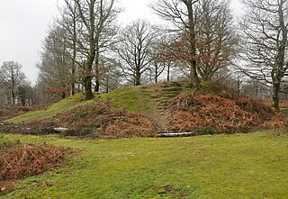
Hembury Castle is an Iron Age hillfort about a mile north-west of the village of Buckfast on the south-eastern edge of Dartmoor in Devon, England. The fort is about 178 metres above sea level on a promontory between the River Dart on the east and the Holy Brook, south-west. The slope down to the River Dart is very steep and is covered by Hembury Woods which is now a Site of Special Scientific Interest.

Okehampton Hamlets is a civil parish in the Borough of West Devon and the English county of Devon, it runs independently from the Okehampton Town Council, meetings are held at the Meldon Village Hall.
Shaugh Prior is a village and civil parish on the south-western side of Dartmoor in the county of Devon, England. It is situated about 8 miles north-east of the historic centre of the city of Plymouth. In 2001 its population was 751. The parish stretches from the edge of Plymouth to the high moorland of Dartmoor. The River Plym forms its western and northern boundaries up to the river's source at Plym Head. The higher parts of the parish are rich in Bronze Age monuments such as cists and cairns, and there is much evidence of tin mining. The area of Lee Moor that has been much mined for china clay is within the parish, but outside the Dartmoor National Park.

Luffincott is a civil parish in the far west of Devon, England. It forms part of the local government district of Torridge and lies about six miles south of the town of Holsworthy. The parish is surrounded clockwise from the north by the parishes of Tetcott, Ashwater, St Giles on the Heath and Northcott. Its western border follows the River Tamar which forms the county boundary with Cornwall.

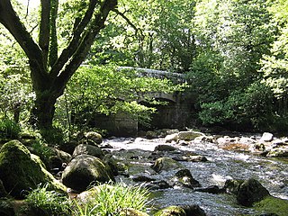
Meldon Viaduct is a disused railway viaduct crossing the West Okement River at Meldon, 2.5 miles (4.0 km) south-west of Okehampton, on the edge of Dartmoor in Devon, South West England. This truss bridge was constructed from wrought iron, instead of stone or brick arches. It opened in 1874 for a single track; in 1879 its width was doubled for a second track. Although regular services were withdrawn in 1968, the bridge was used for shunting by a local quarry. In the 1990s the remaining single track was removed.


