
An estuary is a partially enclosed coastal body of brackish water with one or more rivers or streams flowing into it, and with a free connection to the open sea. Estuaries form a transition zone between river environments and maritime environments and are an example of an ecotone. Estuaries are subject both to marine influences such as tides, waves, and the influx of saline water and to fluvial influences such as flows of freshwater and sediment. The mixing of seawater and freshwater provides high levels of nutrients both in the water column and in sediment, making estuaries among the most productive natural habitats in the world.

The River Axe is a 22-mile (35 km) long river in the counties of Dorset, Somerset and Devon, in the south-west of England. It rises in Dorset and flows south to Lyme Bay which it enters through the Axe Estuary in Devon. It is a shallow, non-navigable river, although its mouth at Axmouth has some boating activity. The name Axe derives from a Common Brittonic word meaning "abounding in fish", and is cognate with pysg, the Welsh word for fish.

The River Dart is a river in Devon, England, that rises high on Dartmoor and flows for 75 kilometres (47 mi) to the sea at Dartmouth.

South Hams is a local government district on the south coast of Devon, England. Services divide between those provided by its own Council headquartered in Totnes, and those provided by Devon County Council headquartered in the city of Exeter.
The River Exe in England rises at Exe Head, near the village of Simonsbath, on Exmoor in Somerset, 8.4 kilometres (5 mi) from the Bristol Channel coast, but flows more or less directly due south, so that most of its length lies in Devon. It flows for 60 miles (96 km) and reaches the sea at a substantial ria, the Exe Estuary, on the south coast of Devon. Historically, its lowest bridging point was the Old Exe Bridge in Exeter, the largest settlement on the river, but there is now a viaduct for the M5 motorway about 3 kilometres (2 mi) south of the city centre.

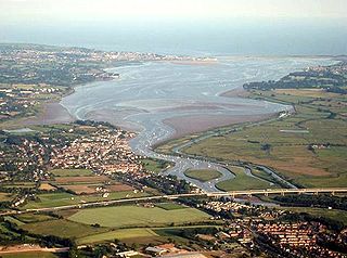
The River Teign or is a river in the county of Devon, England. It is 31 mi (50 km) long and rises on Dartmoor, becomes an estuary just below Newton Abbot and reaches the English Channel at Teignmouth.

Narragansett Bay is a bay and estuary on the north side of Rhode Island Sound covering 147 square miles (380 km2), 120.5 square miles (312 km2) of which is in Rhode Island. The bay forms New England's largest estuary, which functions as an expansive natural harbor and includes a small archipelago. Small parts of the bay extend into Massachusetts.

The River Fal flows through Cornwall, England, rising at Pentevale on Goss Moor and reaching the English Channel at Falmouth. On or near the banks of the Fal are the castles of Pendennis and St Mawes as well as Trelissick Garden. The River Fal separates the Roseland peninsula from the rest of Cornwall. Like most of its kind on the south coast of Cornwall and Devon, the Fal estuary is a classic ria, or drowned river valley. The Fal estuary from Tregony to the Truro River was originally called Hafaraell.

South West Devon is a constituency represented in the House of Commons of the UK Parliament since 1997 by Sir Gary Streeter, a Conservative.

The Dee Estuary is a large estuary by means of which the River Dee flows into Liverpool Bay. The estuary starts near Shotton after a five-mile (8 km) 'canalised' section and the river soon swells to be several miles wide forming the boundary between the Wirral Peninsula in north-west England and Flintshire in north-east Wales. The Dee Estuary's largest towns along it include Hollywell, Flint, Connah's Quay, Shotton, Queensferry, Saltney Ferry, Chester (City), Heswall, West Kirby and Neston as well as other villages and towns alongside it. The A548 also passes along the estuary in Wales and parts of Cheshire West and Chester and Merseyside in England. The North Wales Coast Line follows the course of the Dee Estuary between Prestatyn and Chester.
A tidal river is a river whose flow and level are influenced by tides. A section of a larger river affected by the tides is a tidal reach, but it may sometimes be considered a tidal river if it has been given a separate name.

Noss Mayo is a village in the civil parish of Newton and Noss in the South Hams district of South West Devon, England, about 6 miles (10 km) south-east of Plymouth. It lies about one mile (1.6 km) inland, on the southern bank of Newton Creek, an arm of the estuary of the River Yealm. On the opposite, northern bank of the creek is Newton Ferrers, a slightly larger settlement. The two villages were included in the top 20 prettiest towns and villages in Devon in a list compiled by readers of the "Visit Devon" website. The population was 510 in 1991.

Newton Ferrers is a village and former manor and ecclesiastical parish in the English county of Devon; it is now in the civil parish of Newton and Noss. It is situated on a creek of the River Yealm estuary, about 6 miles (10 km) south-east of the City of Plymouth. It lies within the South Devon Area of Outstanding Natural Beauty. According to the United Kingdom Census 2011 the population of the village of Newton Ferrers was 1,268 and that of the electoral ward of Newton and Noss was 1,814.

The A379 is a road in the English county of Devon. It links points on the edges of that county's two principal cities, Exeter and Plymouth, by an indirect and largely coastal route. The A38 provides a faster and more direct inland route between Exeter and Plymouth, whilst the A380 provides a similarly faster route between Exeter and the Torbay area. However the A379 serves many small coastal communities and ports along the coast. The indented nature of the South Devon coast means that the road is usually out of sight of the sea, but the many rivers and estuaries are crossed by bridges and, in one case, a cable ferry.

The San Francisco Estuary together with the Sacramento–San Joaquin River Delta represents a highly altered ecosystem. The region has been heavily re-engineered to accommodate the needs of water delivery, shipping, agriculture, and most recently, suburban development. These needs have wrought direct changes in the movement of water and the nature of the landscape, and indirect changes from the introduction of non-native species. New species have altered the architecture of the food web as surely as levees have altered the landscape of islands and channels that form the complex system known as the Delta.
Estuarine water circulation is controlled by the inflow of rivers, the tides, rainfall and evaporation, the wind, and other oceanic events such as an upwelling, an eddy, and storms. Estuarine water circulation patterns are influenced by vertical mixing and stratification, and can affect residence time and exposure time.
Estuary freshwater inflow is the freshwater that flows into an estuary. Other types of environmental flows include instream flow, the freshwater water flowing in rivers or streams, and estuary outflow, the outflow from an estuary to the ocean.

Newton and Noss is a civil parish in the South Hams district of Devon, England comprising the villages of Newton Ferrers and Noss Mayo and outlying hamlets such as Membland.The population of the parish taken at the 2011 census was 1,814.

The Percuil River is an estuary and stream draining the southern part of the Roseland Peninsula of Cornwall, UK and is one of three major tidal creeks of the River Fal. The small port and holiday destination of St Mawes is on the western shore and is linked to Place Creek on the eastern shore by the Place Ferry. The ferry is used by walkers on the South West Coast Path.
The Stilbaai Marine Protected Area is an inshore conservation region in the territorial waters near Stilbaai on the south coast of the Western Cape province of South Africa.

