Dartmoor is an upland area in southern Devon, England. The moorland and surrounding land has been protected by National Park status since 1951. Dartmoor National Park covers 954 km2 (368 sq mi).

Chudleigh Knighton is a small village in Devon, England, near to Newton Abbot and Bovey Tracey.

Moretonhampstead is a market town, parish and ancient manor in Devon, situated on the north-eastern edge of Dartmoor, within the Dartmoor National Park. The parish now includes the hamlet of Doccombe, and it is surrounded clockwise from the north by the parishes of Drewsteignton, Dunsford, Bridford, Bovey Tracey, Lustleigh, North Bovey and Chagford.

The River Teign or is a river in the county of Devon, England. It is 31 mi (50 km) long and rises on Dartmoor, becomes an estuary just below Newton Abbot and reaches the English Channel at Teignmouth.

Teignbridge is a local government district in Devon, England. Its council is based in Newton Abbot.

Bovey Tracey is a small town and civil parish in Devon, England, on the edge of Dartmoor, its proximity to which gives rise to the "slogan" used on the town's boundary signs, "The Gateway to the Moor". It is often known locally as "Bovey". It is about 10 miles south-west of Exeter and lies on the A382 road, about halfway between Newton Abbot and Moretonhampstead. The village is at the centre of the electoral ward of Bovey. At the 2011 census the population of this ward was 7,721.

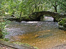
Lustleigh is a small village and civil parish nestled in the Wrey Valley, inside the Dartmoor National Park in Devon, England. It is between the towns of Bovey Tracey and Moretonhampstead.
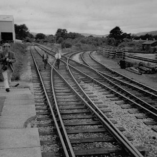
The Moretonhampstead and South Devon Railway was a 7 ft 1⁄4 in broad gauge railway which linked the South Devon Railway at Newton Abbot railway station with Bovey, Lustleigh and Moretonhampstead, Devon, England.
The Teign Valley line was a single-track railway line that ran from Heathfield, Devon, to Exeter via the Teign Valley. It joined the South Devon main line at Exeter City Basin Junction.

Trusham is a small village in the Teign Valley, between Newton Abbot and Exeter, in Devon, England. The name originates from the Celtic Trisma, meaning "brushwood" or "fallen leaves". It became Trisme for about 400 years, and then in the 16th century Tryssame or Trysham. A pub, the Cridford Inn, was opened in 1985 by converting part of an old farmhouse and adjoining barn.

Lustleigh station was on the Moretonhampstead and South Devon Railway serving the village of Lustleigh, Devon, England.
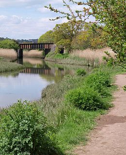
The Hackney Canal was a short canal in Devon, England, that linked the Hackney Clay Cellars to the River Teign. It was privately built by Lord Clifford in 1843, and throughout its life carried ball clay for use in the production of pottery. It closed in 1928, when its function was replaced by road vehicles.

The A382 is a road in South West England, connecting Newton Abbot to the A38, then to Bovey Tracey and on through Moretonhampstead to the A30.
Chudleigh Knighton Halt was on the Teign Valley Line serving the small village of Chudleigh Knighton, Devon, England. The halt, built by the Great Western Railway at a later date than most of the other stations on the line, was located on the west side of Pipehouse Lane off the B3344, to the south of the village.

Teigngrace is a civil parish centred on a hamlet that lies about two miles north of the town of Newton Abbot in Devon, England. According to the 2001 census, its population was 235, compared to 190 a century earlier. The western boundary of the parish mostly runs along the A382 road; its short northern boundary along the A38; and its eastern partly along the rivers Bovey and Teign. It comes to a point at its southern extremity, near Newton Abbot Racecourse. The parish is surrounded, clockwise from the north, by the parishes of Bovey Tracey, Kingsteignton, Newton Abbot and a small part of Ilsington.

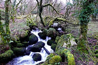
Fingle Bridge is a 17th-century stone arch bridge carrying an unclassified road over the River Teign near Drewsteignton, within Dartmoor National Park in Devon, England. This packhorse bridge has three arches and the two central piers are surrounded by triangular cutwaters extending upwards to form pedestrian refuges, and is a Grade II* listed building.
The Walla Brook is the name of four different streams on Dartmoor, England:

Becky Falls, originally known as Becka Falls, is a tourist attraction in Dartmoor, England, centered on a waterfall of around 20 metres down a boulder-strewn bed. In addition to the waterfall as the centrepiece, there is a woodland park with features such as a children's zoo, woodland trail, and crafts.
Rippon Tor is a striking tor on eastern Dartmoor, in England, that stands at 473 metres (1,552 ft) above sea level. It has three cairns, of which are some of Dartmoor's largest, a triangulation pillar, and several rock piles that overlook the northern high moors near Fernworthy Forest and Great Mis Tor. Field boundaries surround the tor.