The River Exe in England rises at Exe Head, near the village of Simonsbath, on Exmoor in Somerset, 8.4 kilometres (5 mi) from the Bristol Channel coast, but flows more or less directly due south, so that most of its length lies in Devon. It flows for 60 miles (96 km) and reaches the sea at a substantial ria, the Exe Estuary, on the south coast of Devon. Historically, its lowest bridging point was the Old Exe Bridge in Exeter, the largest settlement on the river, but there is now a viaduct for the M5 motorway about 3 kilometres (2 mi) south of the city centre.

The Avocet Line is the railway line in Devon, England connecting Exeter with Exmouth. It was originally built by the London and South Western Railway, and was historically known as the Exmouth branch railway. The line follows the Exe Estuary for about half of its route, from just outside Topsham to Exmouth, giving views of the estuary. The line is named after the pied avocet, which lives in the estuary.

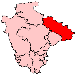
East Devon is a constituency represented in the House of Commons of the UK Parliament since 2019 by Simon Jupp of the Conservative Party.
Tiverton and Honiton is a constituency in Devon, England. The current MP is Richard Foord of the Liberal Democrats, elected at a by-election on 23 June 2022.

Topsham is a town in Devon, England, located on the east side of the River Exe, immediately north of its confluence with the River Clyst and the former's estuary, between Exeter and Exmouth. Topsham is a historic port and was designated a town by a 1300 royal charter granted by Edward I; it was formally amalgamated into the City of Exeter in 1966. The population of the town, recorded at the 2021 census, is 4,146.

Topsham railway station is the railway station serving the town of Topsham in the English county of Devon. It is the passing place for the otherwise single-track branch line from Exmouth Junction to Exmouth. Both the loop and adjacent level crossing are remotely worked from the signal box at Exmouth Junction.

Exminster is a village situated on the southern edge of the City of Exeter on the western side of the Exeter ship canal and River Exe in the county of Devon, England. It is around 6 km (3.7 mi) south of the centre of Exeter, and has a population of 3,084, increasing to 3,368 at the 2011 census.
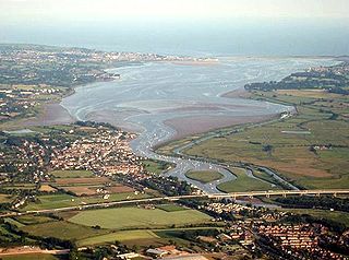
The Exe estuary is an estuary on the south coast of Devon, England.
Woodbury is a village and civil parish in East Devon in the English county of Devon, 7 miles (11 km) south east of the city of Exeter. At the 2011 Census the village had a population of 1,605, and the parish had a population of 3,466. It lies on the east bank of the Exe Estuary, has borders – clockwise from the estuary – with the district of Exeter and then the parishes of Clyst St George, Clyst St Mary, Farringdon, Colaton Raleigh, Bicton and Lympstone. Woodbury is part of the electoral ward of Woodbury and Lympstone whose population at the 2011 Census was 5,260.

The A379 is a road in the English county of Devon. It links points on the edges of that county's two principal cities, Exeter and Plymouth, by an indirect and largely coastal route. The A38 provides a faster and more direct inland route between Exeter and Plymouth, whilst the A380 provides a similarly faster route between Exeter and the Torbay area. However the A379 serves many small coastal communities and ports along the coast. The indented nature of the South Devon coast means that the road is usually out of sight of the sea, but the many rivers and estuaries are crossed by bridges and, in one case, a cable ferry.
Clyst St Mary is a small village and civil parish 3 miles (4.8 km) east of Exeter on the main roads to Exmouth and Sidmouth in East Devon. The name comes from the Celtic word clyst meaning 'clear stream'. The village is a major part of the electoral ward of Clyst Valley. At the 2011 Census this ward population was 2,326.

Countess Wear is a district within the city of Exeter, Devon, England. It lies about two miles south-east of the city centre, on the north bank of the estuary of the River Exe. Historically an estate known as Weare, part of the manor of Topsham, was in this area. From the late 13th century, the construction of weirs in the River Exe by the Countess, and later, the Earls of Devon damaged the prosperity of Exeter to the benefit of Topsham which was downstream of the obstructions, and was owned by the Earls.

Bowling Green Marsh is a nature reserve located on the confluence of the River Exe and the River Clyst, near the town of Topsham in Devon. It is managed by the RSPB.

Clyst Honiton is an English village and civil parish five miles from Exeter in the East Devon district, in the county of Devon. The church is St Michael and All Angels. Exeter International Airport which opened in 1938 is located on the outskirts of the village. The village was originally on the main A30 road from Exeter to Honiton but was bypassed in the 1990s. Another bypass to the east of the village linking the A30 to the new developments around Cranbrook opened in October 2013.

Exton is a village in East Devon, Devon, England, situated on the east bank of the River Clyst, as it flows through the wider Exe Estuary. The A376 road passes through the east side of the village. The town of Topsham is 1 mile (1.6 km) to the northwest.
Clyst St George is a village and civil parish in East Devon, England, adjoining the River Clyst some 4 miles (6.4 km) southeast of Exeter and 5 miles (8.0 km) north of Exmouth.
