Economy of Devon

Last updated

Part of the seafront of Torquay, south Devon, at high tide Torquay.devon.750pix.jpg
Part of the seafront of Torquay, south Devon, at high tide

Devon has the 19th largest economy in England out of 46 ceremonial counties. Situated in the region of South West England, it is a maritime county. Like neighbouring Cornwall to the west, Devon is disadvantaged economically compared to other parts of southern England, owing to the decline of a number of core industries, notably fishing, mining and farming. Consequently, most of Devon has qualified for the European Community's Objective 2 status, particularly around Exmoor, Bideford Bay and the Hartland Point peninsula which is somewhat cut off from industrial Britain due to poor road and rail transport links. These areas of North Devon are, however, only around 50 miles (80 km) by boat from Swansea in Wales. A proposal which has the backing of both the Welsh Assembly Government and the South West Regional Assembly, as well as Devon County Council, is a year-round ferry service from either Ilfracombe or Bideford to Swansea, which it is hoped would stimulate economic growth in both south-west Wales and the north coasts of Devon and Cornwall.[ citation needed ]

Contents

The 2001 UK foot and mouth crisis harmed the farming community severely. [1]

The attractive lifestyle of the area is drawing in new industries which are not heavily dependent upon geographical location[ citation needed ]; Dartmoor, for instance, has recently seen a significant rise in the percentage of its inhabitants involved in the financial services sector. In 2003, the Met Office, the UK's national and international weather service, moved to Exeter. Devon is one of the rural counties, with the advantages and challenges characteristic of these. Despite this, the county's economy is also heavily influenced by its two main urban centres, Plymouth and Exeter.[ citation needed ] Nearly half of the holdings of the Duchy of Cornwall are in Devon, including a large area of farmland.[ citation needed ]

View of HMNB Devonport, the naval base in Plymouth HMNB Devonport.jpg
View of HMNB Devonport, the naval base in Plymouth

Since the rise of seaside resorts with the arrival of the railways in the 19th century, Devon's economy has been heavily reliant on tourism. The county's economy has followed the declining trend of British seaside resorts since the mid 20th century, with some recent revival. This revival has been aided by the designation of much of Devon's countryside and coastline as the Dartmoor and Exmoor national parks, and the Jurassic Coast and Cornwall and West Devon Mining Landscape World Heritage Sites. In 2004 the county's tourist revenue was £1.2 billion. [2]

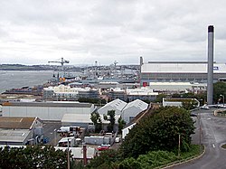
The Met Office is in Exeter as is Connaught plc, and Pennon Group, the water company. The Wrigley Company (chewing gum) and HMNB Devonport (the largest naval base in western Europe) are in Plymouth. Torquay was home to Beverage Brands, the producers of WKD Original Vodka. Britannia Royal Naval College is at Dartmouth.

Long established industries

Mining for tin and copper was carried on in Devon from ancient times until the 1930s: see Dartmoor tin-mining. Agriculture has been an important industry in South West England since the 19th century: approximately 80% of land in the South West of England is in agricultural use (19.6% of England's total). [3]

In the later 19th and early 20th centuries there were a number of potteries in the county, mainly based around Torquay in the south (for instance Aller Vale Pottery), and Barnstaple in the north. At first these made high-quality art pottery, but later declined to the manufacture of mass-produced mottoware for the tourist industry.

Statistics

The remains of a Dartmoor blowing house, showing the furnace and mouldstone Lower blowing house, River Walkham, looking N.jpg
The remains of a Dartmoor blowing house, showing the furnace and mouldstone
A Red Devon (North Devon) bull Red Devon bull.jpg
A Red Devon (North Devon) bull

This is a chart of trend of regional gross value added of Devon at current basic prices published (pp. 240–253) by Office for National Statistics with figures in millions of pounds. [4]

YearRegional Gross Value AddedAgricultureIndustryServices<
19956,1633911,7464,027
20007,4972861,8135,398
20038,6703251,8536,492

Related Research Articles

<span class="mw-page-title-main">Cornwall</span> County of England

Cornwall is a historic county and ceremonial county in South West England. It is recognised as one of the Celtic nations, and is the homeland of the Cornish people. Cornwall is bordered to the north and west by the Atlantic Ocean, to the south by the English Channel, and to the east by the county of Devon, with the River Tamar forming the border between them. Cornwall forms the westernmost part of the South West Peninsula of the island of Great Britain. The southwesternmost point is Land's End and the southernmost Lizard Point. Cornwall has a population of 568,210 and an area of 3,563 km2 (1,376 sq mi). The county has been administered since 2009 by the unitary authority, Cornwall Council. The ceremonial county of Cornwall also includes the Isles of Scilly, which are administered separately. The administrative centre of Cornwall is Truro, its only city.

<span class="mw-page-title-main">Devon</span> County in South West England

Devon is a county in South West England, reaching from the Bristol Channel in the north to the English Channel in the south. It is bounded by Cornwall to the west, Somerset to the north-east and Dorset to the east. The county includes the districts of East Devon, Mid Devon, North Devon, South Hams, Teignbridge, Torridge and West Devon and the city of Exeter, its county town. The other two large urban areas Plymouth and Torbay are each geographically part of Devon, but are administered as unitary authorities. Combined as a ceremonial county, Devon's area is 6,707 km2 and its population is about 1.2 million.

<span class="mw-page-title-main">South West England</span> Region of England

South West England, or the South West of England, is one of nine official regions of England. It consists of the counties of Bristol, Cornwall, Dorset, Devon, Gloucestershire, Somerset and Wiltshire. Cities and large towns in the region include Bath, Bristol, Bournemouth, Cheltenham, Exeter, Gloucester, Plymouth and Swindon. It is geographically the largest of the nine regions of England covering 9,200 square miles (23,800 km2), but the third-least populous, with approximately five million residents.

<span class="mw-page-title-main">South West Coast Path</span> Long-distance footpath in England

The South West Coast Path is England's longest waymarked long-distance footpath and a National Trail. It stretches for 630 miles (1,014 km), running from Minehead in Somerset, along the coasts of Devon and Cornwall, to Poole Harbour in Dorset. Because it rises and falls with every river mouth, it is also one of the more challenging trails. The total height climbed has been calculated to be 114,931 ft (35,031 m), almost four times the height of Mount Everest. It has been voted 'Britain's Best Walking route' twice in a row by readers of The Ramblers' Walk magazine, and regularly features in lists of the world's best walks.

Ivybridge is a town and civil parish in the South Hams, in Devon, England. It lies about thirteen miles east of Plymouth. It is at the southern extremity of Dartmoor, a National Park of England and Wales and lies along the A38 "Devon Expressway" road. There are two electoral wards in Ivybridge East and Ivybridge West with a total population of 11,851.

<span class="mw-page-title-main">Teignmouth</span> Town in Devon, England

Teignmouth is a seaside town, fishing port and civil parish in the English county of Devon. It is situated on the north bank of the estuary mouth of the River Teign, about 12 miles south of Exeter. The town had a population of 14,749 at the last census in 2011.

<span class="mw-page-title-main">Flag of Devon</span> Flag of English county

The Flag of Devon, properly St Petroc's Cross, is the flag of the English county of Devon. It is dedicated to Saint Petroc, a local saint with numerous dedications throughout Devon. It is notable for its creation through two web-based polls.

<span class="mw-page-title-main">History of Cornwall</span> County in England, United Kingdom

The history of Cornwall goes back to the Paleolithic, but in this period Cornwall only had sporadic visits by groups of humans. Continuous occupation started around 10,000 years ago after the end of the last ice age. When recorded history started in the first century BCE, the spoken language was Common Brittonic, and that would develop into Southwestern Brittonic and then the Cornish language. Cornwall was part of the territory of the tribe of the Dumnonii that included modern-day Devon and parts of Somerset. After a period of Roman rule, Cornwall reverted to rule by independent Romano-British leaders and continued to have a close relationship with Brittany and Wales as well as southern Ireland, which neighboured across the Celtic Sea. After the collapse of Dumnonia, the remaining territory of Cornwall came into conflict with neighbouring Wessex.

<span class="mw-page-title-main">History of Devon</span>

Devon is a county in south west England, bordering Cornwall to the west with Dorset and Somerset to the east. There is evidence of occupation in the county from Stone Age times onward. Its recorded history starts in the Roman period when it was a civitas. It was then a separate kingdom for a number of centuries until it was incorporated into early England. It has remained a largely agriculture based region ever since though tourism is now very important.

<span class="mw-page-title-main">Tarka Trail</span> Series of footpaths and cycle paths in North Devon, England

The Tarka Trail is a series of footpaths and cyclepaths around north Devon, England that follow the route taken by the fictional Tarka the Otter in the book of that name. It covers a total of 180 miles (290 km) in a figure-of-eight route, centred on Barnstaple.

<span class="mw-page-title-main">Copplestone</span> Village in Devon, England

Copplestone is a village, former manor and civil parish in Mid Devon in the English county of Devon. It is not an ecclesiastical parish as it has no church of its own, which reflects its status as a relatively recent settlement which grew up around the ancient "Copleston Cross" that stands at the junction of the three ancient ecclesiastical parishes of Colebrooke, Crediton and Down St Mary.

<span class="mw-page-title-main">Mining in Cornwall and Devon</span> Mining in the English counties of Cornwall and Devon

Mining in Cornwall and Devon, in the southwest of England, began in the early Bronze Age, around 2150 BC. Tin, and later copper, were the most commonly extracted metals. Some tin mining continued long after the mining of other metals had become unprofitable, but ended in the late 20th century. In 2021, it was announced that a new mine was extracting battery-grade lithium carbonate, more than 20 years after the closure of the last South Crofty tin mine in Cornwall in 1998.

<span class="mw-page-title-main">Economy of Cornwall</span> Regional economy

The economy of Cornwall in South West England, is largely dependent upon agriculture followed by tourism. Cornwall is one of the poorest areas in the United Kingdom with a GVA of 70.9% of the national average in 2015. and is one of four UK areas that qualified for poverty-related grants from the EU. Farming and food processing contributed £366 million to the county, equal to 5.3% of Cornwall’s total GVA. The agricultural/food industry in Cornwall employs 9,500 people, 23,700 are employed in the food industry in Cornwall The Cornish economy also depends heavily on its successful tourist industry which contributes 12% of Cornwall's GDP and supports about 1 in 5 jobs. Tourism contributed £1.85 billion to the Cornish economy in 2011.

The Okehampton–Bude line was a railway line built to serve Holsworthy in Devon, and Bude on the Cornish coast near the Devon border in England. The line branched from the main line at Meldon Junction to the west of Okehampton on the northern edge of Dartmoor. The line opened in 1879 to Holsworthy and in 1898 to Bude. It is now closed.

<span class="mw-page-title-main">Cuisine of Devon</span>

The cuisine of Devon in England has influenced, and been influenced, by other British cuisine.

South Devon is the southern part of Devon, England. Because Devon has its major population centres on its two coasts, the county is divided informally into North Devon and South Devon. In a narrower sense "South Devon" is used to refer to the part of Devon south of Exeter and Dartmoor, including Plymouth, Torbay and the districts of South Hams, West Devon and Teignbridge.

<span class="mw-page-title-main">North Bovey</span> Village and civil parish in Devon, England

North Bovey is a village and civil parish situated on the south-eastern side of Dartmoor National Park, Devon, England, about 11 miles WSW of the city of Exeter and 1.5 miles SSW of Moretonhampstead. The village lies above the eastern bank of the River Bovey from which it takes its name. In 2001 the population of the parish was 274, compared to 418 in 1901 and 519 in 1801.

<span class="mw-page-title-main">Devon Redlands</span> Natural region in southwest England

The Devon Redlands is a natural region in southwest Britain that has been designated as National Character Area (NCA) 148 by Natural England.

The Devon Rugby Football Union is the governing body for the sport of rugby union in the county of Devon in England. The union is the constituent body of the Rugby Football Union (RFU) for Devon, and administers and organises rugby union clubs and competitions in the county. It also administers the Devon county rugby representative teams.

References

  1. In Devon, the county council estimated that 1,200 jobs would be lost in agriculture and ancillary rural industriesHansard, 25 April 2001
  2. Devon County Council, 2005. Tourism trends in Devon Archived 26 March 2009 at the Wayback Machine .
  3. Archived 20 October 2009 at the Wayback Machine , South West Chamber of Rural Enterprise
  4. Microsoft Word - Regional GVA Article.doc Archived 1 December 2007 at the Wayback Machine