The River Dane is a tributary of the River Weaver that originates in the Peak District area of England. The name of the river is probably from the Old Welsh dafn, meaning a "drop or trickle", implying a slow-moving river.

The River Dart is a river in Devon, England, that rises high on Dartmoor and flows for 75 kilometres (47 mi) to the sea at Dartmouth.

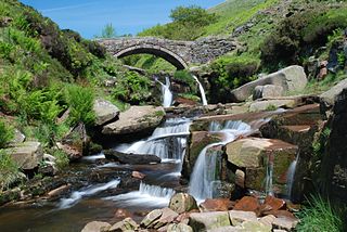
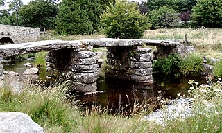
A clapper bridge is an ancient form of bridge found on the moors of the English West Country and in other upland areas of the United Kingdom including Snowdonia and Anglesey, Cumbria, Derbyshire, Yorkshire, Lancashire, and in northern Wester Ross and north-west Sutherland in Scotland. It is formed by large flat slabs of stone, often granite or schist. These can be supported on stone piers across rivers, or rest on the banks of streams.
Black Torrington is a village and civil parish in Torridge, Devon, England, situated between the towns of Holsworthy and Hatherleigh. It is located on and named after the River Torridge. In the 2021 UK census, the population of Black Torrington was recorded as having been 528.

Dartmeet is a popular tourist spot in the centre of Dartmoor, Devon, England at grid reference SX672731.
Wycoller is a hamlet in the civil parish of Trawden Forest in Pendle, Lancashire, England. It is 3 miles (4.8 km) east of Colne, near to the junction of the Lancashire, West Yorkshire and North Yorkshire borders.

The River Devon is a tributary of the River Trent, which rises in Leicestershire and joins the Trent at Newark in Nottinghamshire, England. In its upper reaches, it supplies Knipton Reservoir, which was built to supply water to the Grantham Canal, and Belvoir Lakes, designed by Capability Brown. It passes under the Grantham Canal, and then through Bottesford, where it is spanned by five railway bridges, only one of which is still used for its original purpose. On the outskirts of Newark, it passes by two Civil War structures, and just before it joins the Trent it becomes navigable, with a marina located on the west bank. Its name is pronounced "Deevon", not as spelt.

A packhorse bridge is a bridge intended to carry packhorses across a river or stream. Typically a packhorse bridge consists of one or more narrow masonry arches, and has low parapets so as not to interfere with the panniers borne by the horses. Multi-arched examples sometimes have triangular cutwaters that are extended upward to form pedestrian refuges.
Bondleigh is a village and civil parish in the West Devon district of Devon, England, on the River Taw, north of North Tawton. According to the 2011 census it had a population of 167.

Two Bridges is an isolated location on the river West Dart in the heart of Dartmoor National Park in Devon, England. It is situated around 2.5 km (1.6 mi) northeast of Princetown at the intersection of the two roads that cross Dartmoor: one is the old turnpike road which was built across Dartmoor in the late 18th century ; the other is the B3357.

Coade stone or Lithodipyra or Lithodipra is stoneware that was often described as an artificial stone in the late 18th and early 19th centuries. It was used for moulding neoclassical statues, architectural decorations and garden ornaments of the highest quality that remain virtually weatherproof today.

The River Barle runs from the Chains on northern Exmoor, in Somerset, England to join the River Exe at Exebridge, Devon. The river and the Barle Valley are both designated as biological Sites of Special Scientific Interest.
The East Dart River is one of the two main tributaries of the River Dart in Devon, England.
Newbridge or New Bridge is a Grade II* listed medieval bridge over the River Dart, Dartmoor, Devon, England.

Holne Bridge is a Grade II* listed medieval bridge over the River Dart, Dartmoor, Devon, England. It is on the road between Ashburton and Two Bridges, about 1.5 miles or 2.5 km from Ashburton, and connects Holne Chase to Ausewell. The narrowness of both this bridge and nearby New Bridge means that the length and width of vehicles on this road are restricted.

Dartmouth Harbour is a natural port located in Dartmouth, Devon, England. It is situated at the mouth of the River Dart on the English Channel. Bayard's Cove Fort is a small fort, which was built to defend the harbour's entrance. The crafts which dock at the port are mainly local fishing vessels, naval ships and luxury yachts; warships routinely visit the harbour. The River Dart is navigable from Dartmouth to the old weir location at Totnes.

The Drewe Arms is a Grade II* listed public house on the north side of The Square in Drewsteignton, Devon.

Bradfield Dale is a rural valley 12 kilometres (7.5 mi) west-northwest of the City of Sheffield in England. The valley stands within the north-eastern boundary of the Peak District National Park just west of the village of Low Bradfield. The dale is drained by the Strines Dike which becomes the Dale Dike lower down the valley, these being the headwaters of the River Loxley. The dale contains two reservoirs, Strines and Dale Dike, and a third, Agden Reservoir, stands in a side valley just above Low Bradfield. The dale is characterised by agricultural land interspersed with farming and residential buildings. It is approximately 5 kilometres (3.1 mi) long from its foot at Low Bradfield to its head on Strines Moor.
Stara Bridge is a clapper bridge across the River Lynher in east Cornwall, England, dating to the Late Middle Ages and now scheduled under the Ancient Monuments and Archaeological Areas Act 1979 as a rare surviving example of such bridge types. The surrounding area is known as Starabridge.

