
The River Teign is a river in the county of Devon, England. It is 31 mi (50 km) long and rises on Dartmoor, becomes an estuary just below Newton Abbot and reaches the English Channel at Teignmouth.

Widecombe in the Moor is a village and large civil parish in Dartmoor National Park in Devon, England. Its church is known as the Cathedral of the Moors on account of its tall tower and its size, relative to the small population it serves. It is a favourite tourist centre, partly for its scenic character and partly for its connection to the popular song “Widecombe Fair”.

Bovey Tracey is a small town and civil parish in Devon, England, on the edge of Dartmoor, its proximity to which gives rise to the "slogan" used on the town's boundary signs, "The Gateway to the Moor". It is often known locally as "Bovey". It is about 10 miles south-west of Exeter and lies on the A382 road, about halfway between Newton Abbot and Moretonhampstead. The village is at the centre of the electoral ward of Bovey. At the 2011 census the population of this ward was 7,721.

Lustleigh is a small village and civil parish nestled in the Wrey Valley, inside the Dartmoor National Park in Devon, England. It is between the towns of Bovey Tracey and Moretonhampstead. The village has often been named amongst the best or prettiest villages in the country in various publications, particularly due to the traditional thatched buildings in the village centre.

Broadwoodkelly is a village and civil parish in the West Devon district of Devon, England. According to the 2001 census it had a population of 218. The village is situated about 9 miles (14 km) north of Okehampton.

Buckland in the Moor is a village and civil parish in the Teignbridge district of Devon, England. According to the 2001 census it had a population of 94. The village is in Dartmoor.
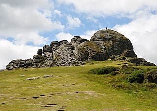
Haytor, also known as Haytor Rocks, Hay Tor, or occasionally Hey Tor, is a granite tor on the eastern edge of Dartmoor in the English county of Devon.
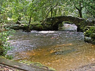
The River Bovey rises on the eastern side of Dartmoor in Devon, England, and is the largest tributary to the River Teign. The river has two main source streams, both rising within a mile of each other, either side of the B3212 road between Moretonhampstead and Postbridge, before joining at Jurston.
The Moretonhampstead and South Devon Railway was a 7 ft 1⁄4 in broad gauge railway which linked the South Devon Railway at Newton Abbot railway station with Bovey, Lustleigh and Moretonhampstead, Devon, England.

The Stover Canal is a canal located in Devon, England. It was opened in 1792 and served the ball clay industry until it closed in the early 1940s. Today it is derelict, but the Stover Canal Society is aiming to restore it and reopen it to navigation.

The Haytor Granite Tramway was a tramway built to convey granite from Haytor Down, Dartmoor, Devon to the Stover Canal. It was very unusual in that the track was formed of granite sections, shaped to guide the wheels of horse-drawn wagons.

The A382 is a road in South West England, connecting Newton Abbot to the A38, then to Bovey Tracey and on through Moretonhampstead to the A30.
Teignbridge Hundred was the name of one of thirty two ancient administrative units of Devon, England. The hundred was listed in the Domesday survey of 1086 as comprising 34 settlements.

North Bovey is a village and civil parish situated on the south-eastern side of Dartmoor National Park, Devon, England, about 11 miles WSW of the city of Exeter and 1.5 miles SSW of Moretonhampstead. The village lies above the eastern bank of the River Bovey from which it takes its name. In 2001 the population of the parish was 274, compared to 418 in 1901 and 519 in 1801.

Teigngrace is a civil parish centred on a hamlet that lies about two miles north of the town of Newton Abbot in Devon, England. According to the 2001 census, its population was 235, compared to 190 a century earlier. The western boundary of the parish mostly runs along the A382 road; its short northern boundary along the A38; and its eastern partly along the rivers Bovey and Teign. It comes to a point at its southern extremity, near Newton Abbot Racecourse. The parish is surrounded, clockwise from the north, by the parishes of Bovey Tracey, Kingsteignton, Newton Abbot and a small part of Ilsington.
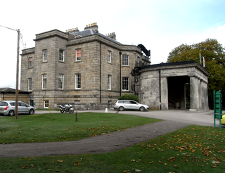
Stover is a historic estate in the parish of Teigngrace, about half way between the towns of Newton Abbot and Bovey Tracey in South Devon, England. It was bought by James Templer (1722–1782) in 1765 and passed through three generations of that family before being bought by Edward St Maur, 11th Duke of Somerset in 1829.

Hennock is a village and civil parish about 3 miles west north west of Chudleigh, in the Teignbridge district, in the county of Devon, England. In 2011 the parish had a population of 1747. The parish touches Bovey Tracey, Kingsteignton, Christow, Chudleigh and Trusham.
This article describes the geology of Dartmoor National Park in Devon, in south-west England. Dartmoor gained national park status in 1951 but the designated area of 954 km2 (368 sq mi) extends beyond the upland of Dartmoor itself to include much of the surrounding land, particularly in the northeast. The geology of the national park consists of a 625 km2 (241 sq mi) core of granite intruded during the early Permian period into a sequence of sedimentary rocks originating in the Devonian and Carboniferous periods. These rocks were faulted and folded, sometimes, intensely, during the Variscan orogeny. Thermal metamorphism has also taken place around the margins of the granite pluton altering the character of the sedimentary rocks whilst mineral veins were emplaced within the granite. A small outlier of Palaeogene sediments occurs on the eastern boundary of the national park.


