

Upper Dart is a section of the River Dart, Dartmoor. It is perhaps the second most popular section of whitewater for kayakers and canoeists in England, particularly for experienced paddlers. This section is followed on by the Dart Loop.
Upper Dart is a section of the River Dart, Dartmoor. It is perhaps the second most popular section of whitewater for kayakers and canoeists in England, particularly for experienced paddlers. This section is followed on by the Dart Loop.
The section's length is approximately 4.3 miles (6.9 kilometres) in length.
This section is loosely Graded at 4, but varies tremendously on rain and ground water levels. The Dart has been known to rise in minutes, changing drastically from a quiet trickle to a raging torrent.
There is a gauge on the section below which gives an accurate level, however this requires you to run that section in order to see it. It is much easier to see the level at Newbridge [1] before driving to the get in. This gauge is known as the slab, on the river left at the "put-in" for the "loop" section.
The river East Dart runs through the car park, and access to the river can be made from here. The best "put in" is to walk out of the car park, over the road, and then down to the river's edge just downstream of the road bridge, just upstream from Dartmeet.
The Upper Dart section has an easier run in and run out of the main section of rapids in the middle of the run. Within this middle section there are a number of features on the Upper Dart, only notable rapids are mentioned here. These are referred to in English White Water by the British Canoe Union. [2] [1]
The first significant steep rapid made up of numerous boulders. The entry is straight forward, and the twisting path makes for the first Class IV whitewater, where a long pool Eagle Flats awaits below.
An island divides the flow, with a long boulder garden down the left, and easy rapids to a steeper exit on the right. Towards the end of the island, the two channels join to make a steep exit into a bedrock feature.
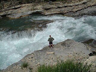
After a long straight, the river bends river and drops over 3 wide bedrock ledges, that at low and medium flows is straight forward, and the water level increases, more significant stoppers form on each of the ledges.
A series of river wide ledges and slides, with a large pool, Mel Pool, halfway down. Much easier in low water, but at high levels many stoppers are powerful and hold swimmers. Sneak routes exist, and should be used. A series of ledges from Broadledge, finish in a diagonal ramp at Mel Pool, where in high water makes for a huge cushion wave and the centre of difficulties when in flood. Mel Pool Steps, has a number of routes, with the a series of small slides that leads to easier water. This section also belies its name – it's closer to half a mile.
A diagonal drop with cushion wave, chunky stopper, large rocks with the water funnelled between them. A chicken chute exists at certain levels.
Complex rocky set of drops, complete with siphons. River left section has a slot, middle section has rocks with a high possibility of pinning. More dangerous at lower water levels, at high levels it can wash out.

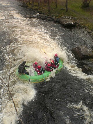
Rafting and whitewater rafting are recreational outdoor activities which use an inflatable raft to navigate a river or other body of water. This is often done on whitewater or different degrees of rough water. Dealing with risk is often a part of the experience.
Whitewater forms in the context of rapids, in particular, when a river's gradient changes enough to generate so much turbulence that air is trapped within the water. This forms an unstable current that froths, making the water appear opaque and white.

The River Dart is a river in Devon, England, that rises high on Dartmoor and flows for 75 kilometres (47 mi) to the sea at Dartmouth.

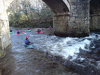
Whitewater kayaking is an outdoor adventure sport where paddlers navigate a river in a specially designed kayak. Whitewater kayaking includes several styles: river running, creeking, slalom, playboating, and squirt boating. Each style offers a different way to experience the thrill and beauty of whitewater environments. Various techniques help paddlers navigate rivers, such as paddle strokes, rolling, and boofing. Whitewater kayaking requires a lot of essential equipment to make a “kayaking kit,” such as a whitewater-specific kayak, spray skirt, paddle, helmet, and PFD.

Dartmeet is a popular tourist spot in the centre of Dartmoor, Devon, England at grid reference SX672731.

Afon Tryweryn is a river in the north of Wales which starts at Llyn Tryweryn in the Snowdonia National Park and after 19 kilometres (12 mi) joins the river Dee at Bala. One of the main tributaries of the Dee, it was dammed in 1965 to form Llyn Celyn. The Tryweryn flooding forcibly removed residents of the village of Capel Celyn despite popular and political opposition in Wales. The resulting graffiti "Cofiwch Dryweryn" near Llanrhystud became and remains a popular icon of Welsh feeling. Water is stored in Llyn Celyn in winter when flows are high, and released over the summer to maintain the flow in the Dee (water from the Dee is used as the water supply for large areas of north-east Wales, and for the Wirral and much of Liverpool in England.
The international scale of river difficulty is an American system used to rate the difficulty of navigating a stretch of river, or a single rapid. The scale was created by the American Whitewater Association to evaluate rivers throughout the world, hence international in the title. It should not be confused with the internationally used whitewater scale, which is published and adapted by a committee of the International Canoe Federation (ICF). The grade reflects the technical difficulty and skill level required associated with the section of river. The scale is of use to various water sports and activities, such as rafting, riverboarding, whitewater canoeing, stand up paddle surfing, and whitewater kayaking.

The Green River is a dam-release river that flows through the mountains of North Carolina, south of Asheville. The Green has numerous tributaries, but much of its water flows from a confluence with Big Hungry Creek. The Green River is itself a tributary of the Broad River. The river is dammed to form Lake Summit, in Tuxedo, North Carolina, and Lake Adger near Mill Spring, NC. The Green River is named for its deep green color but runs brown after heavy rains.

The Kettle is an 83.6-mile-long (134.5 km) tributary of the St. Croix River in eastern Minnesota in the United States. Via the St. Croix River, it is part of the watershed of the Mississippi River. The river's English name is due to the large number of large rounded holes (kettles) in the sandstone in and around the river, carved out by the swirling waters of the river. The river's Dakota name Céġa watpa entered into English via the Anishinaabe people's Akiko-ziibi, both meaning "Kettle River".

The Kananaskis River is a mountain river in western Alberta, Canada. It is a tributary of the Bow River, crossing the length of Kananaskis Country.

Canolfan Tryweryn is the National White Water Centre for Wales, and is based near Bala in north Wales. In 1986, it developed the first commercial white water rafting operation in the UK. The centre is home to paddlesport National Governing Body Canoe Wales.

Hertford Castle Weir is a weir located in Hertford near to Hertford Castle and next to Hertford Theatre.

Creeking is a branch of canoeing and kayaking that involves descending very steep low-volume whitewater. It is usually performed in specialized canoes and kayaks specifically designed to withstand the extreme whitewater environment in which the activity occurs. In addition, the canoes and kayaks give the paddler improved performance and maneuverability needed to avoid river obstacles.
The Bee Cliff is a prominent northeast Tennessee geological limestone feature with high caves that overlooks the Watauga River and the Siam community of Carter County, Tennessee.
Newbridge or New Bridge is a Grade II* listed medieval bridge over the River Dart, Dartmoor, Devon, England.
The Loop is a section of the River Dart, Dartmoor, also known as the Dart Loop.

Whitewater canoeing is the sport of paddling a canoe on a moving body of water, typically a whitewater river. Whitewater canoeing can range from simple, carefree gently moving water, to demanding, dangerous whitewater. River rapids are graded like ski runs according to the difficulty, danger or severity of the rapid. Whitewater grades range from I or 1 to VI or 6. Grade/Class I can be described as slightly moving water with ripples. Grade/Class VI can be described as severe or almost unrunnable whitewater, such as Niagara Falls.

The Ocoee Whitewater Center, near Ducktown, Tennessee, United States, was the canoe slalom venue for the 1996 Summer Olympics in Atlanta, and is the only in-river course to be used for Olympic slalom competition. A 1,640 foot stretch of the Upper Ocoee River was narrowed by two-thirds to create the drops and eddies needed for a slalom course. Today, the course is watered only on summer weekends, 34 days a year, for use by guided rafts and private boaters. When the river has water, 24 commercial rafting companies take more than 750 raft passengers through the course each day.

Canoeing – recreational boating activity or paddle sport in which you kneel or sit facing forward in an open or closed-decked canoe, and propel yourself with a single-bladed paddle, under your own power.
| Main disciplines | |
|---|---|
| Olympics | |
| Other disciplines | |
| ICF championships |
|
| Recreation | |
| Modern boats | |
| Traditional boats | |
| Techniques | |
| Equipment | |
| Venues | |
| Competitions | |
| Festivals | |
| Governing bodies | |
| Other organisations | |
| Media | |