Taplow

Last updated

Taplow
Taplow church - geograph.org.uk - 60104.jpg
The mock-medieval parish church of St Nicholas, built in 1911.
Taplow village centre - geograph.org.uk - 59903.jpg
Berry Hill, part of the developed traditional core
Buckinghamshire UK location map.svg
Red pog.svg
Taplow
Location within Buckinghamshire
Area11.22 km2 (4.33 sq mi)
Population1,669 (2011 census) [1]
  Density 149/km2 (390/sq mi)
OS grid reference SU9182
Civil parish
  • Taplow
Unitary authority
Ceremonial county
Region
Country England
Sovereign state United Kingdom
Post town MAIDENHEAD
Postcode district SL6
Dialling code 01628
Police Thames Valley
Fire Buckinghamshire
Ambulance South Central
UK Parliament
List of places
UK
England
Buckinghamshire
51°31′52″N0°41′13″W / 51.531°N 0.687°W / 51.531; -0.687

Taplow is a village and civil parish in the Unitary Authority of Buckinghamshire, England. It sits on the left bank of the River Thames, facing Maidenhead in the neighbouring county of Berkshire, with Cippenham and Burnham to the east. It is the south-westernmost settlement in Buckinghamshire.

Contents

The village features a Grade II listed mock-medieval church, the parish church of St Nicholas, [2] as well as a school of the same name. Taplow railway station, on the Great Western Main Line, serves the village, with services to London Paddington, Reading and Oxford. There are two conservation areas in the parish, the Taplow Village Conservation Area [3] and the Taplow Riverside Conservation Area. [4] Footpaths connect all parts of the parish to Maidenhead Bridge and to Burnham Beeches, a modest, hilly wood marking the start of the Chiltern Hills.

History

The village has a geological Site of Special Scientific Interest, South Lodge Pit, dating to the late Cretaceous. [5] [6]

The village's name is Anglo-Saxon in origin, and means Tæppa's barrow; the Anglo-Saxon burial mound of Tæppa can still be visited, and important artefacts excavated there are now in the British Museum, notably a gold belt buckle. Taplow was recorded in the Domesday Book of 1086 as Thapeslau. Taplow Court nearby is also the site of an early Iron Age hill fort and was the site of the manor house. [7] [8]

William Grenfell, 1st Baron Desborough lived at Taplow Court. [9] Neighbouring is Cliveden, former home and parkland of Nancy Astor in the parish. Both aspects of Cliveden are today open under the National Trust scheme though part of the main building is used as a hotel for visiting dignitaries to the UK.

In 1883 a number of important Anglo-Saxon royal grave goods were discovered, reflecting similar discoveries in Prittlewell, Broomfiled, and Sutton Hoo. Though the overall collection is less than that from the ship-burial in Mound 1 at Sutton Hoo, many individual objects are closely comparable and of similar quality.[ citation needed ]

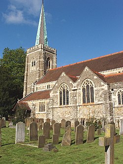
The church of St Nicholas was built in 1911 but includes one of the earliest surviving brass memorials to a civilian in England, made in about 1350, which would place it during the Black Death. [2]

Demography

Taplow compared
2001 UK CensusTaplow wardSouth Bucks boroughEngland
Population1,58461,94549,138,831
Foreign born14.9%12.2%9.2%
White96.1%93.4%90.9%
Asian2.3%4.5%4.6%
Black0.0%0.4%2.3%
Christian73.4%75.6%71.7%
Muslim0.4%1.1%3.1%
Hindu0.8%1.2%1.16
No religion17.1%12.5%14.6%
Unemployed1.3%1.9%3.3%
Retired12.7%14.8%13.5%

At the 2011 UK census, the Taplow electoral ward had a population of 1,669. The ethnicity was 92.5% white, 1.0% mixed race, 5.0% Asian, 0.8% black and 0.7% other. The place of birth of residents was 85.1% United Kingdom, 1% Republic of Ireland, 4.6% other Western European countries, and 9.3% elsewhere. Religion was recorded as 64.1% Christian, 1.6% Buddhist, 0.5% Hindu, 1.6% Sikh, 0.3% Jewish, and 1.3% Muslim. 24.1% were recorded as having no religion, 0% had an alternative religion and 5.9% did not state their religion. [10]

The economic activity of residents aged 16–74 was 46.8% in full-time employment, 8.7% in part-time employment, 16.7% self-employed, 1.3% unemployed, 0.9% students with jobs, 2.5% students without jobs, 12.7% retired, 6.2% looking after home or family, 1.7% permanently sick or disabled and 2.7% economically inactive for other reasons. The industry of employment of residents was 12.3% retail, 11.8% manufacturing, 4.5% construction, 24.6% real estate, 7.8% health and social work, 5.7% education, 9.1% transport and communications, 2.7% public administration, 6.7% hotels and restaurants, 2.7% finance, 3% agriculture and 9.1% other. Compared with national figures, the ward had a relatively high proportion of workers in agriculture and real estate. According to Office for National Statistics estimates, during the period of April 2001 to March 2002 the average gross weekly income of households was £840, compared with an average of £660 in South East England. Of the ward's residents aged 16–74, 37.2% had a higher education qualification or the equivalent, compared with 19.9% nationwide. [11]

2011 Published Statistics: Population, home ownership and extracts from Physical Environment, surveyed in 2005 [1]
Output areaHomes owned outrightOwned with a loanSocially rentedPrivately rentedOtherkm2 roadskm2 waterkm2 domestic gardenskm2 domestic buildingskm2 non-domestic buildingsUsual residentskm2
Civil parish35324428139190.2580.4940.4210.0870.086166911.22

Sports

The village's football club, Taplow United F.C., play in the Hellenic Football League. The village cricket club is located on the Cliveden Road and the rugby union side, Phoenix RFC, is located on Institute Road near the railway station.

Notable people

Related Research Articles

<span class="mw-page-title-main">Buckinghamshire</span> County of England

Buckinghamshire, is a ceremonial county in South East England and one of the home counties. It is bordered by Northamptonshire to the north, Bedfordshire to the north-east, Hertfordshire to the east, Greater London to the south-east, Berkshire to the south, and Oxfordshire to the west. The largest settlement is the city of Milton Keynes, and the county town is Aylesbury.

<span class="mw-page-title-main">Bedgrove</span> Human settlement in England

Bedgrove is one of the housing estates of the modern town of Aylesbury in Buckinghamshire, though it takes its name from a farm and hamlet that stood in the area until the area was cleared for building in the late 1950s. At the time it was built it was the largest housing estate of its kind in the country. The housing estate is on the south side of the town. The farm was where Pevensey Close now stands.

<span class="mw-page-title-main">Cliveden</span> 17th century Italianate mansion

Cliveden is an English country house and estate in the care of the National Trust in Buckinghamshire, on the border with Berkshire. The Italianate mansion, also known as Cliveden House, crowns an outlying ridge of the Chiltern Hills close to the South Bucks villages of Burnham and Taplow. The main house sits 40 metres (130 ft) above the banks of the River Thames, and its grounds slope down to the river. There have been three houses on this site: the first, built in 1666, burned down in 1795 and the second house (1824) was also destroyed by fire, in 1849. The present Grade I listed house was built in 1851 by the architect Charles Barry for the 2nd Duke of Sutherland.

<span class="mw-page-title-main">Dorney</span> Human settlement in England

Dorney is a village and civil parish in the Unitary Authority of Buckinghamshire, England, bordering on the River Thames to the west and south, and bisected by the Jubilee River. In 2011 it had a population of 752. It is 2.3 miles (3.7 km) west of neighbouring Eton, which is a slightly larger parish.

<span class="mw-page-title-main">Great Missenden</span> Human settlement in England

Great Missenden is an affluent village and civil parish in the Misbourne Valley in the Chiltern Hills in Buckinghamshire, England, situated between the towns of Amersham and Wendover. It adjoins the village of Little Kingshill, and is a mile from Little Missenden and the village of Prestwood.

<span class="mw-page-title-main">Burnham, Buckinghamshire</span> Human settlement in England

Burnham is a large village and civil parish that lies north of the River Thames in Buckinghamshire, between the towns of Maidenhead and Slough, about 24 miles west of Charing Cross, London. It is probably best known for the nearby Burnham Beeches woodland.

<span class="mw-page-title-main">Farnham Royal</span> Human settlement in England

Farnham Royal is a village and civil parish within Buckinghamshire, England. It is in the south of the county, immediately north of Slough, and around 22 miles west of Charing Cross, Central London. Within the parish boundary is the village of Farnham Common and the hamlet of Farnham Park.

<span class="mw-page-title-main">Hazlemere</span> Village and civil parish in England

Hazlemere is a large village and civil parish in Buckinghamshire, England, 2.5 miles (4.0 km) northeast of High Wycombe on the A404 leading to Amersham, which intersects with the B474 at Hazlemere. To the north of the village is the hamlet of Holmer Green, which is in the civil parish of Little Missenden.

Hitcham was a village in Buckinghamshire, England. Today it is indistinguishable from the extended village of Burnham and is no longer marked on Ordnance Survey 1:50000 maps as a separate settlement. It is to the west of Burnham, close to the village of Taplow, and adjacent to the common on which Burnham Beeches stands.

<span class="mw-page-title-main">Holmer Green</span> Human settlement in England

Holmer Green is a village in the civil parish of Little Missenden, in Buckinghamshire, England. It is next to Hazlemere, about 3 miles (5 km) south of Great Missenden.

<span class="mw-page-title-main">Nash, Buckinghamshire</span> Human settlement in England

Nash is a village and also a civil parish in Buckinghamshire, England, within the Buckinghamshire Council unitary authority area. It is in the north of the county, about 5 miles (8.0 km) south-west of Milton Keynes and 4 miles (6.4 km) east of Buckingham. According to the 2011 census, the population total of Nash was 417.

Chorleywood is both a village and a civil parish in the Three Rivers District, Hertfordshire, on the border with Buckinghamshire, approximately 20 miles (32 km) northwest of Charing Cross. The village is adjacent to the Chiltern Hills Area of Outstanding Natural Beauty and is part of the London commuter belt included in the government-defined Greater London Urban Area. Chorleywood was historically part of the parish of Rickmansworth, becoming a separate ecclesiastical parish in 1845 and a separate civil parish in 1898. The population of the parish was 11,286 at the 2011 census.

<span class="mw-page-title-main">Beaconsfield (UK Parliament constituency)</span> Parliamentary constituency in the United Kingdom since 1974

Beaconsfield is a constituency in Buckinghamshire represented in the House of Commons of the UK Parliament since 2019 by Joy Morrissey of the Conservative Party. She succeeded Independent and former Conservative Dominic Grieve, whom she defeated following his suspension from the party. The constituency was established for the February 1974 general election.

Eton Rural District was a rural district in the administrative county of Buckinghamshire, England, covering an area in the south-east of the county. It was named after but did not contain Eton, which was an urban district.

<span class="mw-page-title-main">Southchurch</span> Inner city area of Southend-on-Sea in Essex, England

Southchurch is a suburb and former civil parish in Southend-on-Sea in the ceremonial county of Essex, England. England. In 2011 the ward had a population of 9,710.

<span class="mw-page-title-main">Taplow Court</span> Victorian house in Buckinghamshire, England

Taplow Court is a Victorian house in the village of Taplow in Buckinghamshire, England. Its origins are an Elizabethan manor house, remodelled in the early 17th century. In the 18th century the court was owned by the Earls of Orkney. In the 1850s, the court was sold to Charles Pascoe Grenfell, whose descendants retained ownership until after the Second World War. The court then served as a corporate headquarters for British Telecommunications Research (BTR) an independent research company set up in 1946. BTR was subsequently acquired by Plessey Electronics. In 1988 it was bought by the Buddhist foundation, Soka Gakkai International and serves as their UK headquarters.

<span class="mw-page-title-main">Royal Buckinghamshire Yeomanry</span> Military unit

The Royal Buckinghamshire Yeomanry is an Operational Hygiene Squadron of the Royal Logistic Corps, originally formed as cavalry in 1794, and has also served in artillery and signals roles. The lineage is continued by 710 Operational Hygiene Squadron, Royal Logistic Corps.

<span class="mw-page-title-main">South Lodge Pit</span>

South Lodge Pit is a 0.5-hectare (1.2-acre) geological Site of Special Scientific Interest in Taplow in Buckinghamshire. It is a Geological Conservation Review site.

South Bucks District Council was elected every four years from 1973 until 2020.

<span class="mw-page-title-main">Borough of Slough</span> Borough and unitary authority in England

The Borough of Slough is a borough with unitary authority status in the ceremonial county of Berkshire, Southern England. The borough is centred around the town of Slough and includes Langley. It forms an urban area with parts of Buckinghamshire and extends to the villages of Burnham, Farnham Royal, George Green, and Iver. Part of the district's area was in Buckinghamshire prior to the district's formation and in Middlesex until 1965.

References

  1. 1 2 "Key Statistics: Dwellings; Quick Statistics: Population Density; Physical Environment: Land Use Survey 2005". Archived from the original on 11 February 2003. Retrieved 22 April 2008.
  2. 1 2 Historic England. "Church of St Nicholas (1309135)". National Heritage List for England . Retrieved 25 January 2015.
  3. "Taplow Village Conservation Area" (PDF). South Bucks District Council. June 2008. Archived (PDF) from the original on 4 March 2016. Retrieved 4 November 2015.
  4. "Taplow Riverside Conservation Area" (PDF). South Bucks District Council. October 2007. Archived (PDF) from the original on 4 March 2016. Retrieved 4 November 2015.
  5. "South Lodge Pit citation" (PDF). Sites of Special Scientific Interest. Natural England. Archived (PDF) from the original on 4 March 2016. Retrieved 29 February 2016.
  6. "Map of South Lodge Pit". Sites of Special Scientific Interest. Natural England. Archived from the original on 4 March 2016. Retrieved 29 February 2016.
  7. Bucks Archeological Service Historic Environment Resource Assessment
  8. Hart, Jonathan; Mc Sloy, E. R.; Mudd, Andrew (2011). "A Late Prehistoric Hilltop Settlement and Other Excavations Along the Taplow and Dorney Water Pipeline". Records of Buckinghamshire. Buckinghamshire Archeological Society. 51. Archived from the original on 9 August 2018. Retrieved 8 August 2018.
  9. Christopher Winn, I Never Knew That About the River Thames (Random House, 2010) ISBN   0-09-193357-9 p.138
  10. UK Census (2011). "Local Area Report – Taplow 2011 Census Ward (1237322176)". Nomis. Office for National Statistics . Retrieved 18 February 2018.
  11. "Neighbourhood Statistics". Office for National Statistics. Archived from the original on 25 May 2011. Retrieved 20 April 2008.
  12. "Personal website". Archived from the original on 27 July 2021. Retrieved 27 July 2021.
  13. 1 2 Purser, Phillip (17 October 2002). "Wilfred Greatorex". The Guardian. Archived from the original on 22 April 2021. Retrieved 3 April 2021.
  14. "GRENFELL, Pascoe (1761-1838), of Taplow House, Bucks and 19 Charles Street, St James's, Mdx". History of Parliament Online. Archived from the original on 5 August 2021. Retrieved 1 October 2022.
  15. Lewis, Roger (2 August 2014). "The mad, bad and sad life of Dusty Springfield". The Spectator. Archived from the original on 14 April 2021. Retrieved 3 April 2021.
  16. Deer, Brian (2020). The Doctor Who Fooled the World: Science, Deception, and the War on Vaccines. Baltimore, MD: Johns Hopkins University Press. p. 15. ISBN   978-1-42143-800-9.
  17. "Taplow neighbours pay tribute to 'very friendly' Sir Terry Wogan". Belfast Telegraph. 31 January 2016. Archived from the original on 24 September 2020. Retrieved 3 April 2021.