Geography
Named settlements within the parish include the hamlets of Goosegreen, Kingsfold and Winterfold as well as parts of Strood Green and Rowhook. The area is in the north-west of the Weald, a sloped remnant forest in south-east England and largely a plain by erosion.
The parish land area is 1980 hectares (4892 acres). In the 2001 census 1958 people lived in 784 households, of whom 935 were economically active. At the 2011 Census the population was 2,068. [3]
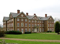
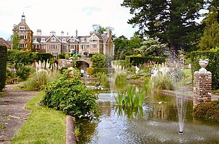
Warnham Court
Formerly Hollands Manor, [6] Warnham Court built in ashlar was built for Henry Tredcroft in 1828. Warnham Court School until August 1996 [7] occupied the building, set in the listed Warnham Park immediately southeast of the village, with extensions and outbuildings by architect Arthur William Blomfield and his son Sir Arthur Blomfield. [n 1]
The park grounds were laid out from the early 1830s, developed in the mid- and late 19th century by the landscape designer Henry, [n 2] and later with a pinetum by Harry J. Veitch. Extended with a wild garden in the early 20th century, the gardens are surrounded by a 19th-century park.
Kingsfold
Kingsfold is the northern settlement on the A24 and Marches Road 2.8 miles (4.5 km) north of Horsham. [4] The village lies close to the Surrey border just south of site of the medieval Shiremark Mill, also known as Capel Mill and Kingsfold Mill which is 20 metres north of the border in Capel. The village has one pub, The Owl.
Goosegreen or Goose Green
Goosegreen consists of a small group of farms and cottages between Warnham and Broadbridge Heath and includes four Grade II listed buildings. [n 3] To the south of the hamlet is a cricket ground, home to the Broadbridge Heath Cricket Club, and tennis courts. Most of the houses are owned or were formerly owned by the Warnham Park Estate, whose offices are at Bailing Hill Farm. The artist Joan Eardley was born at Bailing Hill Farm on 18 May 1921; the family moved to Blackheath in 1926 and then to Scotland in 1939, where she was active for the remainder of her career.
Rowhook
Rowhook is a hamlet on the Broadbridge Heath to Ewhurst, Surrey road 3 miles (5 km) northwest of Horsham. [4] Rowhook lies on a junction of two Roman roads, one being Stane Street (Chichester), the other an unnamed road which runs to the top of "Hurtwood" on the Greensand Ridge in Ewhurst.
From the junction of the A29 and the A281 to the south, [n 4] the course of Stane Street passes through Waterland Farm, becomes a lane which joins the Rowhook Road next to the Chequers Inn, a Grade II listed building, [n 5] and continues in a northeasterly direction towards Ockley in Surrey, where it once again joins the A29.
While divided by the parish boundaries of Warnham, Slinfold and Rudgwick, the majority of the hamlet and in particular, Rowhook Manor, [15] which is a Grade II listed building of early medieval origin, is in Warnham civil parish. [16]

Bramley is a village and civil parish about three miles (5 km) south of Guildford in the Borough of Waverley in Surrey, south east England. Most of the parish lies in the Surrey Hills Area of Outstanding Natural Beauty.

Chiddingfold is a village and civil parish in the Weald in the Waverley district of Surrey, England. It lies on the A283 road between Milford and Petworth. The parish includes the hamlets of Ansteadbrook, High Street Green and Combe Common.

Alfold is a village and civil parish in Surrey, England on the West Sussex border. Alfold is a dispersed or polyfocal village in the Green Belt, which is buffered from all other settlements. The Greensand Way runs north of the village along the Greensand Ridge and two named localities exist to the north and south of the historic village centre which features pubs, a set of stocks and a whipping post.
Dial Post is a village in the Horsham District of West Sussex, England. The civil parish, where the lowest level political meetings are held, is West Grinstead in the north-east - its biggest settlement is 2 miles (3.2 km) east at Partridge Green. It has a population of around 100 based on the average headcount per inhabited dwelling. In 2001 the population of the civil parish as a whole was 2,934

Broadbridge Heath is a village and civil parish in the Horsham district of West Sussex, England. It is about two miles (3 km) west from the historic centre of Horsham. The population of Broadbridge Heath has increased considerably in the first two decades of the twenty-first century because of large scale housing development.

Ewhurst is a rural village and civil parish in the borough of Waverley in Surrey, England. It is located 8.3 miles (13.4 km) south-east of Guildford, 2 miles (3.2 km) east of Cranleigh, and 4.5 miles (7.2 km) south of Shere.
Nuthurst is a village and civil parish in the Horsham district of West Sussex, England. The north of the parish borders Horsham town, with Nuthurst village 3 miles (5 km) south from the border. Within the parish is the estate and largely 19th-century country house of Sedgwick Park.
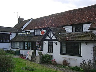
Dormansland is a large village and civil parish with a low population approximately one mile south of Lingfield in Surrey, England. It was founded in the 19th century and is bordered on the east by the county of Kent and on the south by West Sussex and East Sussex, the only area of the county which borders East Sussex. The nearest town is the small town of East Grinstead, immediately across the West Sussex border. The village has an inn named "The Plough" that serves food located opposite the Village Store.

Horsham is a market town on the upper reaches of the River Arun on the fringe of the Weald in West Sussex, England. The town is 31 miles (50 km) south south-west of London, 18.5 miles (30 km) north-west of Brighton and 26 miles (42 km) north-east of the county town of Chichester. Nearby towns include Crawley to the north-east and Haywards Heath and Burgess Hill to the south-east. It is the administrative centre of the Horsham district.

Norton-sub-Hamdon is a village and civil parish in the South Somerset district of the English county of Somerset, situated ten miles west of Yeovil. The village has a population of 743.
Buncton is a small village in the Horsham District of West Sussex, England, part of the civil parish of Wiston 0.5 miles (0.80 km) north. It lies to the east of the A24 road, 11 miles (18 km) as the crow flies, about 18 miles (29 km) by road south of Horsham and 6 miles (9.7 km) north west of Shoreham by Sea.
Blackstone is a hamlet in the civil parish of Woodmancote and the Horsham district of West Sussex, England. Blackstone is significant for its listed 17th- and 18th-century houses and cottages.

Shermanbury is a village and civil parish in the Horsham District of West Sussex, England. It lies on the A281 road approximately 2 miles (3 km) north of Henfield. The present day village consists mainly of a ribbon development of bungalows on the east side of the A281, while the ancient parish church is to the east by Shermanbury Place. Between these is Ewhurst Manor, a 16th-century house on an old moated site with a 14th-century stone gatehouse and nearby artificial lake and farmstead.

Horsham Museum is a museum at Horsham, West Sussex, in South East England. It was founded in August 1893 by volunteers of the Free Christian Church and became part of Horsham District Council in 1974. It is a fully accredited museum and serves both Horsham and its district with the support of the Friends of Horsham Museum and an active volunteer base.

Stokeinteignhead is a village and civil parish in the Teignbridge district of Devon, England, above the southern bank of the estuary of the River Teign. The parish has a short boundary on the estuary, and is otherwise surrounded, clockwise from the north, by the parishes of Shaldon, Torbay, Coffinswell and Haccombe with Combe. It is twinned with the French commune of Trévières, Calvados.

Leigh is a civil parish in the English county of Staffordshire. The parish includes the village of Church Leigh, together with the settlements of Withington, Upper Leigh, Lower Leigh, Morrilow Heath, Middleton Green, Dodsley, Godstone, Nobut and Field.

Warnham & Rusper is an electoral division of West Sussex in the United Kingdom and returns one member to sit on West Sussex County Council. The current County Councillor, Mick Hodgson, is also Vice-Chairman of West Sussex County Council.

Pixham is a chapelry within the parish of Dorking, Surrey on the near side of the confluence of the River Mole and the Pipp Brook to its town, Dorking, which is centred 1 km (0.6 mi) southwest. The town as a whole, uniquely in Surrey, has three railway stations; Pixham adjoins or is the location of two of the three; and is near the junction of the A24 and A25 main roads.

Staplecross is a village in the civil parish of Ewhurst and the Rother district of East Sussex, England. Staplecross is the largest settlement in Ewhurst parish, and is on a southern ridge of the valley of the River Rother which flows through Bodiam at the north of Staplecross. The village is in the High Weald Area of Outstanding Natural Beauty. In 2011 it had a population of 760.