This article possibly contains original research .(July 2015) |
Thakeham | |
---|---|
Church of St Mary | |
Location within West Sussex | |
Area | 11.71 km2 (4.52 sq mi) [1] |
Population | 1,794 [1] 2001 Census 1,816 (Census 2011) [2] |
• Density | 153/km2 (400/sq mi) |
OS grid reference | TQ109172 |
• London | 41 miles (66 km) NNE |
Civil parish |
|
District | |
Shire county | |
Region | |
Country | England |
Sovereign state | United Kingdom |
Post town | PULBOROUGH |
Postcode district | RH20 |
Dialling code | 01798 |
Police | Sussex |
Fire | West Sussex |
Ambulance | South East Coast |
UK Parliament | |
Website | http://www.thakehamparish.gov.uk/ |
Thakeham is a village and civil parish located north of the South Downs in the Horsham District of West Sussex, England. The village is situated approximately 12 miles south-west of Horsham and 11 miles north of the sea-side town of Worthing. Its nearest large village is Storrington (3 miles). The parish includes the hamlets of Abingworth and Goose Green and has a land area of 1170.6 hectares (2891 acres).
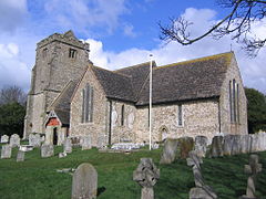
The village is mentioned in Domesday Book,(as Taceham) [3] but human occupation goes back to Neolithic times. The name Thakeham means “thatched homestead [4] ” and the original village had just one main street (“The Street”) which is home to the village's only pub, The White Lion, and St Mary's church (12th century) and is now a designated conservation area. Recent examination of timber beams shows that a hall was constructed on The Street towards the end of Henry VIII's reign (1540s) although the beams themselves may have been felled for another structure in the 1300s.
Towards the end of World War 1, from February 1917 until February 1918, there was a Royal Flying Corps Home Defence day and night landing ground [5] in the north of Thakeham Parish abutting Shipley Parish south/east of Sincox Lane and east of Ingrams Furze. Initially used by BE2c and BE12 aeroplanes operated by the Hove-based 78 Squadron until a tactical rearrangement in September 1917 saw 39 Squadron take over with Bristol F2b Fighters. Both squadrons were tasked with defending south coast targets from attacks by German Gotha bombers. The same location was used post-war for an unknown period by the Royal Air Force as a temporary flying ground and, according to the Worthing Herald of 8 September 1928, large crowds used to spend hours watching the flying and local dances were planned for RAF personnel stationed there. From 1933 to 1935, 'Thakeham Old Aerodrome' was the venue for annual air displays by Alan Cobham's Flying Circus. Local newspapers also promoted further air displays by C W A Scott and Tom Campbell Black in April and June 1936 but these may well have been cancelled as neither event was reported afterwards.
Land use in the parish is predominantly agricultural, dominated by farming and wooded areas (with outstanding bluebell displays in the spring). As well as the original centre in The Street, the parish includes the hamlets of Abingworth and Goose Green.
The parish's main population now groups south of The Street in the Abingworth area, and further south in a section of the north-eastern suburb of Storrington within the Thakeham boundary. In the 2011 census 1816 people lived in 707 households.
The mushroom factory originally existed on two sites - the main remaining site sits between the original village and the edge of Abingworth. A secondary location further south was sold for housing in the early noughties. From the profits of the sale, Sussex Mushrooms modernised and consolidated the going concern at the remaining site. In April 2011 after much delay, Horsham District Council announced they had approved the plans for 150 new homes. By 2018, houses had been built around a cricket pitch. In addition, the developers built a village hall, a veterinary surgery and shop/café.
Heritage assets in the parish include the 13th century Church of the Holy Sepulchre in Warminghurst, and Little Thakeham, [6] a Grade I listed country house on Merrywood Lane, designed by the architect Edwin Lutyens in 1902. Further south are two schools Thakeham Primary and Steyning Grammar Rock Road and Thakeham Tiles, the other industry in the village, all situated on Rock Road.
A village cricket team representing Linfield Mushrooms (as they were then called) folded in the 1970s but a club was revived following a merger with neighbours, West Chiltington, at the end of the 20th century to form West Chiltington & Thakeham Cricket Club. As part of the developer's proposals at Abingworth, a new cricket pitch and pavilion was created as well as football pitches for the currently dormant Thakeham Village FC. The cricket club host their Men's 3rd and 4th XI's plus Women's and some colts games there.
Washington is a village and civil parish in the Horsham District of West Sussex, England. It is located five miles west of Steyning and three miles east of Storrington on the A24 between Horsham and Worthing. The parish covers an area of 1,276 hectares. In the 2001 census 1,930 people lived in 703 households, of whom 820 were economically active. At the 2011 Census the population of the civil parish was 1,867.
Arundel and South Downs is a constituency in West Sussex created in 1997 and represented in the House of Commons of the UK Parliament by Andrew Griffith, a Conservative, since 2019.
Amberley is a village and civil parish in the Horsham District of West Sussex, England. It is situated at the foot of the South Downs, 4 miles (6 km) north of Arundel. Its neighbours are Storrington and West Chiltington. The village is noted for its thatched cottages. A house named "The Thatched House" is one of the village's few non-thatched houses.
Storrington is a town and former civil parish, now in the parish of Storrington and Sullington, in the Horsham district of West Sussex, England. Storrington lies at the foot of the north side of the South Downs. As of 2021 it had a population of around 6,000. It has one main shopping street. The A283 road runs directly through the town and connects Storrington to Steyning in the east and Pulborough in the west. It is three miles west of Washington.
Ashington is a village and civil parish in the Horsham District of West Sussex, England. It lies on the A24 road 3 miles (4.8 km) north-east of Storrington.
Sullington is a village and former civil parish, now in the parish of Storrington and Sullington, in the Horsham district of West Sussex, England. The village lies on the A283 road west of the A24 road, 20 miles (32 km) south of Horsham. In 1961 the parish had a population of 1354. On 1 April 2003 the parish was abolished and merged with Storrington to form "Storrington & Sullington".
West Chiltington is a village and civil parish in the Horsham district of West Sussex, England. It lies on the Storrington to Broadford Bridge road, 2.6 miles (4.2 km) north of Storrington.
Nuthurst is a village and civil parish in the Horsham district of West Sussex, England. The north of the parish borders Horsham town, with Nuthurst village 3 miles (5 km) south from the border. Within the parish is the estate and largely 19th-century country house of Sedgwick Park.
Cootham is a hamlet in the Horsham District of West Sussex, England. It lies on the A283 road 0.9 miles (1.4 km) west of Storrington.
Woodmancote is a village and civil parish in the Horsham District of West Sussex, England. The village is 1 mile (1.5 km) southeast of Henfield on the A281 road. It should not be confused with the other West Sussex village of Woodmancote near Chichester.
Westhampnett is a village, Anglican parish and civil parish in the district of Chichester in West Sussex, England, located 1 mile (1.6 km) northeast of Chichester on the former A27 road, now by-passed. The village is pre-Norman and is home to many listed buildings, including the Saxon church of St Peter, where three bishops of Chichester are buried. The parish of Westhampnett includes most of Goodwood estate, its golf course, motor-racing circuit and airfield.
Nutbourne is a hamlet running north–south situated 1.5 miles (2.4 km) east of Pulborough in the Horsham District of West Sussex and is in Pulborough civil parish. It is in the civil parish of West Chiltington.
Shipley is a village and civil parish in the Horsham District of West Sussex, England. It lies just off the A272 road 6 miles north-east of Storrington. The parish includes the village of Coolham and the hamlets of Dragon's Green, Brooks Green and Broomer's Corner.
Warminghurst is a village and former civil parish, now in the parish of Thakeham, in the Horsham district of West Sussex, England. It lies on the Ashington to Heath Common road 2.4 miles (3.9 km) northeast of Storrington. In 1931 the parish had a population of 93. On 1 April 1933 the parish was abolished and merged with Ashington.
Pulborough is an electoral division of West Sussex in the United Kingdom and returns one member to sit on West Sussex County Council. The current County Councillor, Pat Arculus, is also Cabinet Member for Children and Young People's Services.
St Mary's Church is the Grade I listed Anglican parish church of West Chiltington, a village in the Horsham district of West Sussex, England. The 12th-century building, described as a "showpiece" and "the most attractive part" of the Wealden village, retains many features of historical and architectural interest. These include an exceptionally long hagioscope or squint from the south aisle into the chancel, a porch which may be Sussex's oldest, and a well preserved and extensive scheme of wall paintings. In the Sussex volume of The Buildings of England, Ian Nairn says that the appearance of the church gives "a very happy, unexpected effect, like a French village church".