Falmer is a small village and civil parish in the Lewes District of East Sussex, England, lying between Brighton and Lewes, approximately five miles (8 km) north-east of the former. It is also the site of Brighton & Hove Albion's Falmer Stadium.

Hurstpierpoint is a village in the Mid Sussex district, in the county of West Sussex, England, 4 miles (6.4 km) southwest of Burgess Hill, and 1.5 miles (2.4 km) west of Hassocks railway station. It sits in the civil parish of Hurstpierpoint and Sayers Common which has an area of 2029.88 ha and a population of 7,112.

Henfield is a large village and civil parish in the Horsham District of West Sussex, England. It lies 41 miles (66 km) south of London, 12 miles (19 km) northwest of Brighton, and 30 miles (48 km) east northeast of the county town of Chichester at the road junction of the A281 and A2037. The parish has a land area of 4,285 acres (1,734.1 ha). In the 2001 census 5,012 people lived in 2,153 households, of whom 2,361 were economically active. Other nearby towns include Burgess Hill to the east and Shoreham-by-Sea to the south. The population at the 2011 Census was 5,349.

Ditchling is a village and civil parish in the Lewes District of East Sussex, England. The village is contained within the boundaries of the South Downs National Park; the order confirming the establishment of the park was signed in Ditchling.

Hassocks is a village and civil parish in the Mid Sussex District of West Sussex, England. Its name is believed to derive from the tufts of grass found in the surrounding fields.

Barcombe is an East Sussex village and civil parish in the Lewes District of East Sussex. The parish has four settlements: old Barcombe, the oldest settlement in the parish with the parish church; Barcombe Cross, the more populous settlement and main hub with the amenities and services; the hamlet of Spithurst in the northeast and Town Littleworth in the northwest.

Newick is a village, civil parish and electoral ward in the Lewes District of East Sussex, England. It is located on the A272 road six miles (9.7 km) east of Haywards Heath.
Albourne is a village and civil parish in the Mid Sussex district of West Sussex, England. It lies just off the A23 road three miles (4.8 km) east of Henfield. The parish has a land area of 772.9 hectares (1909 acres). In the 2001 census 600 people lived in 234 households, of whom 321 were economically active. The population at the 2011 Census was 644. The name comes from an alder-lined stream, which is likely to have been the Cutler's Brook.

Upper Beeding is a village and civil parish in the Horsham District of West Sussex, England. It is located at the northern end of the River Adur gap in the South Downs, four miles (6.4 km) north of Shoreham-by-Sea and has a land area of 1,877 hectares. The site is a bridging point over the river: on the opposite bank are Bramber and Steyning, making the whole area somewhat built-up. The civil parish also includes the smaller village of Small Dole to the north, and the village of Edburton to the northeast.

Bolney is a village and civil parish in the Mid Sussex district of West Sussex, England. It lies 36 miles (58 km) south of London, 11 miles (18 km) north of Brighton, and 27 miles (43 km) east northeast of the county town of Chichester, near the junction of the A23 road with the A272 road. The parish has a land area of 1,479.41 hectares. In the 2001 census there were 1209 people living in 455 households of whom 576 were economically active. At the 2011 Census the population had increased to 1,366. Nearby towns include Burgess Hill to the southeast and Haywards Heath to the east.

Chailey is a village and civil parish in the Lewes District of East Sussex, England. It is located 7 miles north of Lewes, on the A272 road from Winchester to Canterbury. The Prime Meridian passes just to the east of Chailey.
Wivelsfield village and the larger adjacent village of Wivelsfield Green are the core of the civil parish of Wivelsfield in the Lewes District of East Sussex, England. The villages are 9.3 miles (15.0 km) north of the city of Brighton and Hove.

Streat is a village and parish in the Lewes district of East Sussex, England, 3 miles (4.8 km) south-east of Burgess Hill and 5 miles (8.0 km) west of Lewes, within the South Downs National Park.
Ansty and Staplefield, previously Cuckfield Rural, is a civil parish in the Mid Sussex District of West Sussex, England, covering an area from the north-west side of Burgess Hill, the whole lying around but mostly to the west of Cuckfield civil parish, from which it was created in 1894 under the Local Government Act 1894. It includes the settlements of Ansty in the south, Staplefield to the north-west and Brook Street to the north-east. It is the largest civil parish in West Sussex, covering an area of 3,869 hectares (14.94 sq mi), and has a population of 1574, increasing to 1,756 at the 2011 Census.

Newtimber is a small village and civil parish in the Mid Sussex District of West Sussex, England. It is located north-west of Brighton. The parish also includes the hamlet of Saddlescombe. The parish lies almost wholly with the South Downs National Park, with the exception of a small section of the parish north of the B2117 road. The planning authority for Newtimber is therefore the South Downs National Park Authority (SDNPA), the statutory planning authority for the National Park area. The downland scarp, which includes Newtimber Hill, Newtimber Holt, Saddlescombe chalk quarry and Summer Down, is mostly part of the Beeding Hill to Newtimber Hill, designated Site of Special Scientific Interest.

Poynings is a village and civil parish in the Mid Sussex District of West Sussex, England. The parish lies wholly with the South Downs National Park. To its south is Brighton and Hove, to its west is the Fulking parish, to its east is the Newtimber parish and to its north is Albourne parish. The planning authority for Poynings is the South Downs National Park Authority (SDNPA), the statutory planning authority for the National Park area.
Twineham is a village and civil parish in the Mid Sussex District of West Sussex, England. It is located eight kilometres to the west of Burgess Hill. The civil parish covers an area of 784 hectares In the 2001 census 271 people lived in 100 households, of whom 139 were economically active. The 2011 Census population was 306.
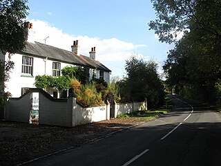
Blackstone is a hamlet in the civil parish of Woodmancote and the Horsham district of West Sussex, England. Blackstone is significant for its listed 17th- and 18th-century houses and cottages.

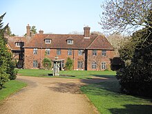
Shermanbury is a village and civil parish in the Horsham District of West Sussex, England. It lies on the A281 road approximately 2 miles (3 km) north of Henfield. The present day village consists mainly of a ribbon development of bungalows on the east side of the A281, while the ancient parish church is to the east by Shermanbury Place. Between these is Ewhurst Manor, a 16th-century house on an old moated site with a 14th-century stone gatehouse and nearby artificial lake and farmstead.

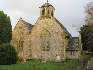
St Giles' Church is a Church of England parish church in the small village of Shermanbury, West Sussex. Placed on the same site as a church recorded in Domesday Book, the present church was largely built in the 13th century but was heavily restored and partially rebuilt in the 18th and 19th centuries. English Heritage has listed it at Grade II* for its architectural and historical importance. The church historian John E. Vigar described it as "one of our Sussex gems" which he had "no hesitation in recommending...to all". Services for the parish continue and also cover the parishes of St Peter's, Henfield and St. Peter's, Woodmancote, which form its united benefice.