Borough of Dartford

Last updated

Dartford
Borough of Dartford
Dartford UK locator map.svg
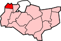
Dartford shown within Kent
Sovereign state United Kingdom
Constituent country England
Region South East England
Non-metropolitan county Kent
Status Non-metropolitan district, Borough
Admin HQ Dartford
Incorporated1 April 1974
Government
  TypeNon-metropolitan district council
  BodyDartford Borough Council
  LeadershipLeader & Cabinet (Conservative)
   MPs Gareth Johnson
Area
  Total28.10 sq mi (72.77 km2)
  Rank227th (of 296)
Population
 (2021)
  Total116,777
  Rank205th (of 296)
  Density4,200/sq mi (1,600/km2)
  Ethnicity
84% White
5%Asian
4% Black
4% Mixed Race
2% Other ethnic group
Time zone UTC0 (GMT)
  Summer (DST) UTC+1 (BST)
ONS code 29UD (ONS)
E07000107 (GSS)
OS grid reference TQ538739
Website www.dartford.gov.uk

The Borough of Dartford is a local government district in the north-west of the county of Kent, England. Its council is based in the town of Dartford. It is part of the contiguous London urban area. It borders the borough of Gravesham to the east, Sevenoaks District to the south, the London Borough of Bexley to the west, and the Thurrock unitary authority in Essex to the north, across the River Thames. The borough was formed on 1 April 1974 by the merger of the Municipal Borough of Dartford, the Swanscombe Urban District, and part of the Dartford Rural District. According to the 2011 Census, its population was 97,365, increasing to 116,800 in the 2021 census.

Contents

Government

Dartford Borough Council
Dartford Borough Council.svg
Leadership
Rosanna Currans,
Conservative
since 24 May 2023
Jeremy Kite,
Conservative
since 27 February 2006
Sarah Martin
Structure
Seats42 councillors
UK Dartford Borough Council 2023.svg
Political groups
Administration (29)
  Conservative (29)
Other parties (13)
  Labour (11)
  Residents Association (1)
  Green (1)
Elections
First past the post
Last election
4 May 2023
Next election
6 May 2027
Meeting place
Dartford Civic Centre, January 2024.jpg
Civic Centre, Home Gardens, Dartford, DA1 1DR
Website
www.dartford.gov.uk

Since 2010, the Dartford constituency's Member of Parliament (MP) is Gareth Johnson (Conservative) who replaced the outgoing Howard Stoate (Labour).

The leader of the council, from February 2006, is Councillor Jeremy Kite (Conservative). Councillors represent the following seventeen wards as of 2018: [1]

NB the boundaries of these wards do not necessarily coincide with the parish boundaries.

Political control

As of May 2019, the council is made up as follows: [2]

PartyCouncillors
Conservative Party 29
Labour Party 10
Swanscombe and Greenhithe Residents Association3

The following civil parishes are also included in the borough:

In addition to the settlements named above, there is the urban village of Joydens Wood to the south-west of the town.

Dartford Youth Council

Dartford also has a youth council called the Dartford Youth Council (DYC) which comprises members of the youth representing local secondary schools, youth groups (such as Scouts). [3] They discuss important issues relating to the youth of Dartford, such as mental health, to staying fit and how they can help and combat those issues. They attend a monthly meeting, at the Dartford Civic Centre. They have represented Dartford's youth in several events. [4] Every November, members attend and represent Dartford Youth Council in the annual Dartford Remembrance Parade. [4]

Communications in the borough

Railways

Ebbsfleet International Ebbsfleet3732.JPG
Ebbsfleet International

There are seven railway stations in the borough: at Stone; Greenhithe (for Bluewater); Swanscombe and Dartford, all on the North Kent Line; and Longfield and Farningham Road on the VictoriaChatham Main Line. From Dartford there are three lines serving London and one to Gravesend, the Medway Towns and eastern Kent. For many services Dartford is the terminus.

Ebbsfleet International railway station on High Speed 1 opened in the east of the borough on 19 November 2007. Six high-speed services to Paris and five to Brussels ran daily from here by Eurostar. However since the Covid Pandemic trains destined for the Continent no longer stop in Kent at all. Despite efforts to reverse this decision, Eurostar have said they will only reconsider the situation sometime in 2025. The station still carries commuters to St Pancras station in London in only 17 minutes, and to Stratford International (next to the 2012 Summer Olympics site) in just 10 minutes, while eastbound commuter services link Ebbsfleet to Ashford International, Dover, Folkestone and other stations in Kent.

Notable bus service

The first of the Fastrack bus services, using a combination of ordinary roads and dedicated 'bus tracks' commenced in March 2006. The service runs from the Temple Hill area of Dartford, through the town centre and on to Bluewater Shopping Centre, Greenhithe, Ebbsfleet International and Gravesend.

Roads

Fastrack at Bluewater Shopping Centre Arriva Southern Counties 4306 on Fastrack A, Bluewater (20894624865) (cropped).jpg
Fastrack at Bluewater Shopping Centre

Three of the county's main roads pass through the borough boundaries: the M25 and M20 motorways and the A2 dual carriageway. The A20, A225 and the A226 roads also cross the borough, among others.

Dartford gives its name to the Dartford Crossing of the River Thames, a pair of road tunnels (constructed in 1963 and 1980), with the Queen Elizabeth II Bridge (October 1991), dual-linking Kent with Essex and connecting sections of the London Orbital M25 motorway.

Housing and architecture

St Nicholas's church, Southfleet, is in the borough. St Nicholas Church - geograph.org.uk - 145162.jpg
St Nicholas's church, Southfleet, is in the borough.

The layout of the district is clustered development in the northern half and buffered, dispersed settlement interspersed by the North Downs which is an escarpment of varied farms and woodland in the south.

Housing is a mixture of relatively high rise in Dartford centre through to low rise in all of the villages.

The number of listed buildings in the district exceeds 50. This includes 7 churches listed in the highest grading in the national listing system (Grade I).

Demography

2011 census

The population rose in the 10 years to 2011 from 85,911 to 97,365, by 13.3%, which was above the national average.

87.3% of residents were born in England, which was 2.5% higher than the average for the South East. The next most common group of countries of birth was the non-EU, however this was 0.3% lower than the average for the South-East and 2% lower than the average for England.

As to residents of EU birth, only 3.3% of the population were such, slightly below the national average and two-thirds of this migration was from the accession countries from 2001 to 2011, a 12.5% higher proportion than that seen nationwide.

As to older people, the borough has a below national and regional proportion. In common with most of the country, an increase in people living in their area above the age of 74 took place, whether through change in preference or most commonly longevity, from 6.5% in 2001 to 7.1% in 2011.

With 80.8% of households with a car or van, this was 6.6% above the national average, however still marginally lower than South East's record and national-high of 81.4%.

1.0% of the population lived in a communal establishment in the area.

As to homes, as 12.6% of properties in the area are detached, these form a smaller minority than the regional and national averages (at 28.0% and 22.3% of dwellings respectively).

Its people in 2011 were more economically active than the regional and national average; while self-employed inhabitants were at parity with the national average, those in full-time employment were 6.0% greater.

As to religion, statistics mirrored closely the national average, save that more Hindus and Sikhs live in the borough, at a combined, equally split 3.2% of the total population and fewer Muslims, also forming 1.6% of the population. Being almost at the mean for the country, Christians form just over 60% of the area's population. [5]

Employment

Exterior of Bluewater Bluewater exterior.JPG
Exterior of Bluewater

Although many of area's traditional industries of papermaking, cement, and pharmaceuticals are in decline or closing down, and many of borough's inhabitants travel away from the borough by rail and road (many commuting to London and other areas for work), there is still a large industrial and commercial base. Included among those areas include 'The Bridge' and Crossways to either side of the Queen Elizabeth II Bridge, areas around Greenhithe and a 740-acre (3.0 km2) site planned to contain five separate 'villages' in the Eastern Quarry near Bluewater Shopping Centre, itself a large employer.

In October 2012 Dartford and Gravesham councils co-announced plans for a major theme park to be built on the Swanscombe peninsula, which would create up to 27,000 jobs by 2018.

See also

Related Research Articles

<span class="mw-page-title-main">Dartford railway station</span> Railway station in Kent, England

Dartford railway station serves the town of Dartford in Kent, England. It is 17 miles 12 chains (27.6 km) down the line from London Charing Cross. Train services from the station are operated by Southeastern and Thameslink. Southeastern also manages the station. Dartford is a major interchange station in the North Kent region of the Southeastern network. Ticket barriers control access to the platforms.

<span class="mw-page-title-main">Swanscombe</span> Human settlement in England

Swanscombe /ˈswɒnzkəm/ is a village in the Borough of Dartford in Kent, England, and the civil parish of Swanscombe and Greenhithe. It is 4.4 miles west of Gravesend and 4.8 miles east of Dartford.

<span class="mw-page-title-main">Northfleet</span> Human settlement in England

Northfleet is a town in the borough of Gravesham in Kent, England. It is located immediately west of Gravesend, and on the border with the Borough of Dartford. Northfleet has its own railway station on the North Kent Line, just east of Ebbsfleet International railway station on the High Speed 1 line.

<span class="mw-page-title-main">Greenhithe, Kent</span> Village in the Borough of Dartford, Kent, England

Greenhithe is a village in the Borough of Dartford in Kent, England, and the civil parish of Swanscombe and Greenhithe. It is located 4 miles east of Dartford and 5 miles west of Gravesend.

<span class="mw-page-title-main">Longfield</span> Village in the Borough of Dartford, Kent, England

Longfield is a village in the Borough of Dartford, Kent, England. It is located 6 miles south east of Dartford and the same distance south-west of Gravesend.

Southfleet is a small village and civil parish in the borough of Dartford in Kent, England. The village is located three miles southwest of Gravesend, while the parish includes within its boundaries the hamlets of Betsham and Westwood.

<span class="mw-page-title-main">Dartford (UK Parliament constituency)</span> UK Parliament constituency since 1885

Dartford is a constituency in Kent represented in the House of Commons of the UK Parliament since 2010 by Gareth Johnson of the Conservative Party. It is the longest bellwether constituency in the country: the party of the winning candidate has gone on to form the government at every UK general election since 1964. Candidates for the largest two parties nationally have polled first and second since 1923 in Dartford.

<span class="mw-page-title-main">Arriva Southern Counties</span> Bus operator in East Sussex, Kent and Essex

Arriva Southern Counties Limited, trading as Arriva Southern Counties, is a bus operator in Kent, Essex, Hemel Hempstead, and Watford in England. It is a subsidiary of Arriva UK Bus.

<span class="mw-page-title-main">Ebbsfleet International railway station</span> Railway station in Kent, England

Ebbsfleet International railway station is in Ebbsfleet Valley, Kent, 10 miles east of London, England, near Dartford and the Bluewater shopping centre to the west and Gravesend to the east. The station, part of the Thames Gateway urban regeneration project, is on the High Speed 1 (HS1) rail line, 400 metres south-west of Northfleet railway station, off the A2 trunk road, 5 mi (8.0 km) from its junction with the M25 motorway. It served as a primary park-and-rail service for the London 2012 Olympics.

<span class="mw-page-title-main">Bean, Kent</span> Human settlement in England

Bean is a village and civil parish in the Borough of Dartford, Kent, England. It is located 4.4 miles south east of Dartford and 5.4 miles south west of Gravesend. In 2011 the parish had a population of 1643.

Swanscombe and Greenhithe is a civil parish in the Borough of Dartford in Kent, England. Swanscombe and Greenhithe is a recent renaming of the ancient parish of Swanscombe, covering Swanscombe and Greenhithe. The parish included much of the Ebbsfleet Valley new town development until 2019. The local council is Swanscombe and Greenhithe Town Council.

<span class="mw-page-title-main">Stonebridge Road</span> Multi-purpose stadium in Northfleet, Kent, England

Stonebridge Road is a multi-purpose stadium in Northfleet, Gravesend, Kent, England, also known as Kuflink Stadium for sponsorship reasons. It is primarily used for football matches. Stonebridge Road was constructed in 1905, and was initially the home of Northfleet FC, which merged with Gravesend FC in 1946. It is currently the home ground of Ebbsfleet United. Thus, Stonebridge Road has been the home of Ebbsfleet and its predecessor football clubs for over 100 years.

Dartford Rural District was a rural district with an area of 34,037 acres (138 km2) in the county of Kent, England. In 1971 it had a population of 64,561 and an electorate of 43,911. At dissolution it was the most populous rural district council in Kent, but had once been larger, having lost territory when Crayford Urban District was created in 1920, and Swanscombe Urban District in 1926.

<span class="mw-page-title-main">Fastrack (bus)</span> Bus Rapid Transit network in Kent, England

Fastrack is a bus rapid transit scheme in the Thames Gateway area of Kent. It consists of three routes, operated by Arriva Southern Counties on behalf of Kent County Council with Prologis and Amazon respectively. Measures used to allow buses to avoid traffic include signal priority, reserved lanes, and dedicated busways.

Ebbsfleet Valley is a new town and redevelopment area in Kent, South East England, and part of the Thames Gateway, southwest of Gravesend. Development is coordinated by the Ebbsfleet Development Corporation.

Elections to Dartford Borough Council were held on 1 May 2003. The whole council was up for election on new boundaries, which reduced the total number of seats from 47 to 44. The election in Longfield, New Barn and Southfleet ward was postponed following the death of Bob Dunn, one of the Conservative candidates. The delayed election returned three Conservative councillors, increasing their number to 21.

New Barn is a village in Kent, England. It is a compact residential area surrounded by open fields which lies four miles southwest of Gravesend. It is in the local government district of Dartford. The villages of New Barn and Longfield are within and give their names to the civil parish of Longfield and New Barn. New Barn is larger in population than Longfield, although has little in the way of services, being a recent development and purely residential in nature

<span class="mw-page-title-main">Baker's Hole</span>

Baker's Hole is a 6.9 hectares geological Site of Special Scientific Interest, mostly consisting of a back-filled quarry, adjacent to Ebbsfleet International railway station in Kent. It is a Geological Conservation Review site. It is a nationally significant site for finds during quarrying of Stone Age tools, which are now dispersed among many museums.

<span class="mw-page-title-main">Axstane Hundred</span> Historical division of Kent, England

Axstane was a hundred in the county of Kent, England. The Hundred of Axstane lay south-east of Dartford and Wilmington Hundred. It is called Achestan in Domesday Book, but by the reign of Edward I it was called Axstane.

References

  1. The Dartford (Electoral Changes) Order 2018 https://www.legislation.gov.uk/uksi/2018/1175/schedule/1/made
  2. Dartford Borough Council http://committeedmz.dartford.gov.uk/mgMemberIndex.aspx?FN=ALPHA&amp%3bJ=2
  3. Approve, IT. "Dartford Youth Council". www.dartford.gov.uk. Retrieved 3 June 2017.
  4. 1 2 "Our Work". Dartford Youth Council. 11 February 2017. Retrieved 3 June 2017.
  5. "2011 Census". Archived from the original on 11 February 2003. Retrieved 21 June 2013.