
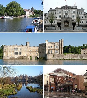
Four major rivers drain the county of Kent, England.
Four major rivers drain the county of Kent, England.
The catchment area of the Medway covers almost 25% of the county. The detailed map has a diagram of that catchment area, which includes its main tributaries: the rivers Eden, Bourne (or Shode), Teise, Beult, Loose and Len.
The River Stour is also known as the Great Stour, especially above its confluence with the Little Stour at Plucks Gutter. Its catchment area covers the eastern part of Kent.
Its tributary is the River Cray.
A minor river from Temple Ewell to Dover
A Wealden river. It is included here since for part of its journey near Bodiam it forms the boundary between Kent and East Sussex.

The River Stour is a river in Kent, England that flows into the North Sea at Pegwell Bay. Above Plucks Gutter, where the Little Stour joins it, the river is normally known as the Great Stour. The upper section of the river, above its confluence with the East Stour at Ashford is sometimes known as the Upper Great Stour or West Stour. In the tidal lower reaches, the artificial Stonar Cut short cuts a large loop in the natural river.

The River East Stour is one of the tributaries of the Great Stour in Kent. The East Stour, 10.3 miles (16.5 km) long,) rises on the Greensand ridge at Postling north of Hythe as a number of small streams. It then flows under the M20 motorway to continue in a westward direction: the river meanders across the Low Weald plain, passing Mersham on the way. The East Stour's confluence with the Great Stour is on both sides of Pledge's Mill at the foot of East Hill, Ashford.
The Little Stour is one of the tributaries of the River Stour in the English county of Kent. The upper reaches of the river are mistakenly known as the Nailbourne, whilst the lower reaches were once known as the Seaton Navigation.
Maidstone is a town in Kent, England, of which it is the county town. Maidstone is historically important and lies 32 miles (51 km) east-south-east of London. The River Medway runs through the centre of the town, linking it with Rochester and the Thames Estuary. Historically, the river carried much of the town's trade as the centre of the agricultural county of Kent, known as the Garden of England. There is evidence of settlement in the area dating back before the Stone Age. The town, part of the borough of Maidstone, has an approximate population of 174,644 as of 2020. There has been a shift in the town's economy since the Second World War away from heavy industry towards light industry and services.
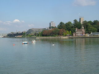
The River Medway is a river in South East England. It rises in the High Weald, Sussex and flows through Tonbridge, Maidstone and the Medway conurbation in Kent, before emptying into the Thames Estuary near Sheerness, a total distance of 70 miles (113 km). About 13 miles (21 km) of the river lies in Sussex, with the remainder being in Kent.

Tonbridge and Malling is a local government district with borough status in Kent, England. Its council is based in West Malling.

The Borough of Tunbridge Wells is a local government district and borough in Kent, England. It takes its name from its main town, Royal Tunbridge Wells.

The Borough of Maidstone is a local government district with borough status in Kent, England. Its administrative centre is Maidstone, the county town of Kent.

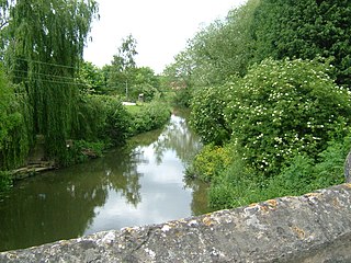
Yalding is a village and civil parish in the Borough of Maidstone in Kent, England. The village is situated 6 miles (9.7 km) south west of Maidstone at a point where the Rivers Teise and Beult join the River Medway. At the 2001 census, the parish, which includes the villages of Benover and Laddingford, had a population of 2,236. increasing to 2,418 at the 2011 Census.

The Medway Valley line is the name given to the railway line linking Strood and the Medway Towns with Maidstone West and onward to Paddock Wood & Tonbridge. High Speed services also link between Maidstone West, Aylesford, Strood and London St Pancras International. The section from Maidstone West to Tonbridge passes through some of Kent's most picturesque countryside along the narrower sections of the River Medway.

Yalding railway station is on the Medway Valley Line in Kent, England, serving the village of Yalding. It is 38 miles 19 chains (61.5 km) down the line from London Charing Cross via Paddock Wood and is situated between Beltring and Wateringbury. The station and all trains that call are operated by Southeastern.
Uppermill or Upper Mill may refer to:

Plucks Gutter is a hamlet in the civil parish of Stourmouth, Kent, England. The hamlet is situated where the Little Stour and Great Stour rivers meet.

The Wateringbury stream is a tributary of the River Medway in Kent, England. It rises at Swanton, West Peckham parish, flows south east towards Mereworth and then flows in a generally easterly direction to join the River Medway at Wateringbury. It is some four miles (6 km) long and powered a number of watermills.

The River Teise is a tributary of the River Medway in Kent, England.
The River Beult is a tributary of the River Medway in South East England.

The River Bewl is a tributary of the River Teise in Kent, England. Its headwaters are in the High Weald, in Sussex between Lamberhurst, Wadhurst and Flimwell. The valley is deeply incised into Tunbridge Wells red sandstone, with a base of alluvium on Wadhurst clay.
The River Medway in England flows for 70 miles (113 km) from Turners Hill, in West Sussex, through Tonbridge, Maidstone and the Medway Towns conurbation in Kent, to the River Thames at Sheerness, where it shares the latter's estuary. The Medway Navigation runs from the Leigh Barrier south of Tonbridge to Allington just north of Maidstone. It is 19 miles (31 km) in length. The Environment Agency is the navigation authority responsible for the navigation.
The Medway and its tributaries and sub-tributaries have been used for over 1,150 years as a source of power. There are over two hundred sites where the use of water power is known. These uses included corn milling, fulling, paper making, iron smelting, pumping water, making gunpowder, vegetable oil extraction, and electricity generation. Today, there is just one watermill working for trade. Those that remain have mostly been converted. Such conversions include a garage, dwellings, restaurants, museums and a wedding venue. Some watermills are mere derelict shells, lower walls or lesser remains. Of the majority, there is nothing to be seen. A large number of tributaries feed into the River Medway. The tributaries that powered watermills will be described in the order that they feed in. The mills are described in order from source to mouth. Left bank and right bank are referred to as though the reader is facing downstream. This article covers the watermills on the tributaries that feed in below Penshurst and above Yalding.
| Wikimedia Commons has media related to Medway and tributaries. . |
| Wikimedia Commons has media related to Medway, Beult and Teise at Yalding . |
| Unitary authorities | |
|---|---|
| Boroughs or districts | |
| Major settlements |
|
| Rivers | See: Rivers of Kent |
| Topics | |