River Wantsum

Last updated
River Wantsum

River Stour Map.jpg

River Stour and Tributaries
Physical characteristics
Main source Reculver
River mouth River Stour
The River Wantsum today. In Roman and medieval times this was a channel a mile and a half wide, linking Reculver and Richborough, capable of taking seagoing boats. The River Wantsum today - geograph.org.uk - 41871.jpg
The River Wantsum today. In Roman and medieval times this was a channel a mile and a half wide, linking Reculver and Richborough, capable of taking seagoing boats.

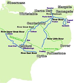
The River Wantsum is a tributary of the River Stour, in Kent, England. Formerly, the River Wantsum and the River Stour together formed the Wantsum Channel, which separated the Isle of Thanet from the mainland of Kent. Now the River Wantsum is little more than a drainage ditch starting at Reculver, and ending where it joins the Stour.

River Stour, Kent river in Kent, England

The River Stour is a river in Kent, England that flows into the North Sea at Pegwell Bay. Above Plucks Gutter, where the Little Stour joins it, the river is normally known as the Great Stour. The upper section of the river, above its confluence with the East Stour at Ashford is sometimes known as the Upper Great Stour or West Stour. In the tidal lower reaches, the artificial Stonar Cut short cuts a large loop in the natural river.

Kent County of England

Kent is a county in South East England and one of the home counties. It borders Greater London to the north west, Surrey to the west and East Sussex to the south west. The county also shares borders with Essex along the estuary of the River Thames, and with the French department of Pas-de-Calais through the Channel Tunnel. The county town is Maidstone.

The Wantsum Channel was a strait separating the Isle of Thanet from the north-eastern extremity of the English county of Kent and connecting the English Channel and the Thames Estuary. It was a major shipping route when Britain was part of the Roman Empire, and continued in use until it was closed by silting in the late Middle Ages. Its course is now represented by the River Stour and the River Wantsum, which is little more than a drainage ditch lying between Reculver and St Nicholas-at-Wade and joins the Stour about 1.7 miles (2.7 km) south-east of Sarre.

Bede, in the 8th century, said that the Wantsum – meaning Wantsum Channel – was "about three furlongs broad [660 yards (600 m)], and is fordable only in two places, for both ends run into the sea". [1] In 1414 there was still a ferry crossing the Wantsum at Sarre, but by 1550 Thanet was no longer an island. At Reculver, the Romans built a fort that was about 1 mile (1.6 km) from the sea, whereas Leland, in the early 16th century, described Reculver as being 0.25 miles (400 m) from the sea, and the great storm of 1809 carried away half of the fort. It is postulated that the eroded material was carried along the shore and blocked the northern mouth of the Wantsum. [2]

Bede 7th and 8th-century Anglo-Saxon monk, writer, and saint

Bede, also known as Saint Bede, Venerable Bede, and Bede the Venerable, was an English Benedictine monk at the monastery of St. Peter and its companion monastery of St. Paul in the Kingdom of Northumbria of the Angles. Born on lands likely belonging to the Monkwearmouth monastery in present day Sunderland, Bede was sent there at the age of seven and later joined Abbot Ceolfrith at the Jarrow monastery, both of whom survived a plague that struck in 686, an outbreak that killed a majority of the population there. While he spent most of his life in the monastery, Bede travelled to several abbeys and monasteries across the British Isles, even visiting the archbishop of York and King Ceolwulf of Northumbria. He is well known as an author, teacher, and scholar, and his most famous work, Ecclesiastical History of the English People, gained him the title "The Father of English History". His ecumenical writings were extensive and included a number of Biblical commentaries and other theological works of exegetical erudition. Another important area of study for Bede was the academic discipline of computus, otherwise known to his contemporaries as the science of calculating calendar dates. One of the more important dates Bede tried to compute was Easter, an effort that was mired with controversy. He also helped establish the practice of dating forward from the birth of Christ, a practice which eventually became commonplace in medieval Europe. Bede was one of the greatest teachers and writers of the Early Middle Ages and is considered by many historians to be the single most important scholar of antiquity for the period between the death of Pope Gregory I in 604 and the coronation of Charlemagne in 800.

Furlong A unit of length equal to 220 yards still used widley in horse racing

A furlong is a measure of distance in imperial units and U.S. customary units equal to one eighth of a mile, equivalent to 660 feet, 220 yards, 40 rods, or 10 chains.

Sarre, Kent human settlement in United Kingdom

Sarre is a village and civil parish in Thanet District in Kent, England. The village is a part of St. Nicholas-at-Wade ecclesiastical parish, after having lost the local church of St. Giles in Elizabethan times; the ecclesiastical parishes were subsequently combined. In its own right Sarre is an Ancient Parish. It has a population of 130, increasing to 222 at the 2011 Census.

The River Wantsum now joins the Great Stour from the north as a small tributary, just before the Little Stour enters it from the south to form what is thereafter known simply as the River Stour.

Little Stour river in the United Kingdom

The Little Stour is one of the tributaries of the River Stour in the English county of Kent. The upper reaches of the river are better known as the Nailbourne, whilst the lower reaches were once known as the Seaton Navigation.

Related Research Articles

Isle of Thanet island

The Isle of Thanet lies at the most easterly point of Kent, England. While in the past it was separated from the mainland by the 600-metre-wide (2,000 ft) Wantsum Channel, it is no longer an island.

Fordwich a town in Canterbury, United Kindom

Fordwich is a remnant market town and a civil parish in east Kent, England, on the River Stour, northeast of Canterbury.

Reculver village in United Kingdom

Reculver is a village and coastal resort about 3 miles (5 km) east of Herne Bay in south-east England, in a ward of the same name, in the City of Canterbury district of Kent. It once occupied a strategic location at the north-western end of the Wantsum Channel, a sea lane that separated the Isle of Thanet and the Kent mainland until the late Middle Ages. This led the Romans to build a small fort there at the time of their conquest of Britain in 43 AD, and, starting late in the 2nd century, they built a larger fort, or castrum, called Regulbium, which later became one of the chain of Saxon Shore forts. The military connection resumed in the Second World War, when the sea off Reculver was used for testing Barnes Wallis's bouncing bombs.

St Nicholas-at-Wade village in the United Kingdom

St Nicholas-at-Wade is both a village and a civil parish in the Thanet District of Kent, England. The parish had a recorded population of 782 at the 2001 Census, increasing t0 852 at the 2011 census. The village of Sarre is part of the civil parish.

Thanet District Non-metropolitan district in England

Thanet is a local government district in Kent, England. Formed under the Local Government Act 1972, it came into being on 1 April 1974 and is governed by Thanet District Council.

Rivers of Kent

Four major rivers drain the county of Kent, England.

Pegwell Bay

Pegwell Bay is a shallow inlet in the English Channel coast astride the estuary of the River Stour north of Sandwich bay, between Ramsgate and Sandwich in Kent. Part of the bay is a nature reserve, with seashore habitats including mudflats and salt marsh with migrating waders and wildfowl. The public can access the nature reserve via Pegwell Bay Country Park, which is off the A256 Ramsgate to Dover road.

Saxon Shore Way

The Saxon Shore Way is a long-distance footpath in England. It starts at Gravesend, Kent, and traces the coast of South-East England as it was in Roman times (note the changed coastline around Romney Marsh) as far as Hastings, East Sussex, 163 miles (262 km) in total.

Chislet village in United Kingdom

Chislet is an English village and rural parish in northeast Kent between Canterbury and the Isle of Thanet. The parish is the second largest in the district. A former spelling, 'Chistlet', is seen in 1418. The population of the civil parish includes the hamlet of Marshside. Most of the land use is fertile agricultural and a significant minority of the land is marsh where low-lying.

Sarre Penn river in the United Kingdom

Sarre Penn is a tributary of the River Stour in Kent, England, joining with the River Wantsum near Sarre, where it is known locally as the Fishbourne Stream.

Plucks Gutter human settlement in United Kingdom

Plucks Gutter is a hamlet in the civil parish of Stourmouth, Kent, England. The hamlet is situated where the Little Stour and Great Stour rivers meet.

A256 road

The A256 is a key road running north-south through East Kent which connects the Thanet towns to Dover. It is operated by Kent County Council as a primary route, and has seen investment in the past to connect traffic to the Port of Ramsgate, and to the Pfizer research centre in Sandwich.

Ebbsfleet, Thanet village in United Kingdom

Ebbsfleet is a hamlet near Ramsgate, Kent, at the head of Pegwell Bay. Historically it was a peninsula on the southern coast of the Isle of Thanet, marking the eastern end of the Wantsum Channel that separated Thanet from the Kentish mainland. It is in the civil parish of Minster-in-Thanet

Regulbium human settlement in United Kingdom

Regulbium was the name of an ancient Roman fort of the Saxon Shore in the vicinity of the modern English resort of Reculver in Kent. Its name derives from the local Celtic language, meaning "great headland" (*Rogulbion).

All Saints Church, Shuart

All Saints' Church, Shuart, in the north-west of the Isle of Thanet, Kent, in the south-east of England, was established in the Anglo-Saxon period as a chapel of ease for the parish of St Mary's Church, Reculver, which was centred on the north-eastern corner of mainland Kent, adjacent to the island. The Isle of Thanet was then separated from the mainland by the sea, which formed a strait known as the Wantsum Channel. The last church on the site was demolished by the early 17th century, and there is nothing remaining above ground to show that a church once stood there.

The geology of Kent in southeast England largely consists of a succession of northward dipping late Mesozoic and Cenozoic sedimentary rocks overlain by a suite of unconsolidated deposits of more recent origin.

Viking Coastal Trail

The Viking Coastal Trail is a 25-mile multi-user route around the Isle of Thanet, keeping as close as is possible to the coast. It is also Regional Route 15 of the National Cycle Network. From Reculver, the trail passes through Margate, Broadstairs and Ramsgate to reach Pegwell Bay, where Vikings first landed in Kent. The Trail then, uses an inland route on quiet lanes, passing through a couple of villages with ancient churches including Minster-in-Thanet Abbey and St Nicholas at Wade, to return to Reculver.

St Marys Church, Reculver

St Mary's Church, Reculver, was founded in the 7th century as either a minster or a monastery on the site of a Roman fort at Reculver, which was then at the north-eastern extremity of Kent in south-eastern England. In 669, the site of the fort was given for this purpose by King Ecgberht of Kent to a priest named Bassa, beginning a connection with Kentish kings that led to King Eadberht II of Kent being buried there in the 760s, and the church becoming very wealthy by the beginning of the 9th century. From the early 9th century to the 10th the church was treated as essentially a piece of property, with ownership passing between kings of Mercia and Wessex and the archbishops of Canterbury. Viking attacks may have extinguished the church's religious community in the 9th century, although an early 11th-century record indicates that the church was then in the hands of a dean accompanied by monks. By the time of Domesday Book, completed in 1086, St Mary's was serving as a parish church.

References

  1. Bede. "XXV". Ecclesiastical History. 1. in Dorothy Whitelock, ed. (1979). English Historical Documents. I. Eyre Methuen. p. 650.
  2. Jessup, Frank (1966). Kent History Illustrated. Maidstone, Kent: Kent Education Committee. p. 72.

Coordinates: 51°23′N1°14′E / 51.383°N 1.233°E / 51.383; 1.233

Geographic coordinate system Coordinate system

A geographic coordinate system is a coordinate system that enables every location on Earth to be specified by a set of numbers, letters or symbols. The coordinates are often chosen such that one of the numbers represents a vertical position and two or three of the numbers represent a horizontal position; alternatively, a geographic position may be expressed in a combined three-dimensional Cartesian vector. A common choice of coordinates is latitude, longitude and elevation. To specify a location on a plane requires a map projection.