Little Stour

Last updated

Little Stour
River Stour Map.jpg
River Stour and Tributaries
Physical characteristics
Source 
  location Lyminge
Mouth  
  location
River Stour
Kent Town Rivers.svg

The Little Stour is one of the tributaries of the River Stour in the English county of Kent. The upper reaches of the river is known as the Nailbourne, whilst the lower reaches were once known as the Seaton Navigation.

Contents

The intermittent source of the Nailbourne is at Lyminge, and in its early reaches from Lyminge to Bekesbourne it forms a chalk stream and winterbourne. Below Bekesbourne it joins the Little Stour, which in turn joins with the Great Stour at Plucks Gutter near East Stourmouth.

Course

Nailbourne

Ethelburga's Well Ethelburga's Well on Well Road - geograph.org.uk - 960720.jpg
Ethelburga's Well

The Nailbourne flows from Lyminge, through the Elham Valley until it joins the Little Stour at Bekesbourne.

The Nailbourne bubbles up beneath St Ethelburga's Well in Tayne Field in the centre of Lyminge. Whilst the stream often holds a plentiful supply of water from Lyminge to Elham throughout the year, it rarely holds any water from Elham to Bishopsbourne even in the winter months. However, in wet years the normally dry ditch can turn into a fast flowing torrent, flooding roads, fields and houses. An example of this was in 2001 when there was extensive flooding throughout the Elham Valley.

There are a number of minor tributaries that flow into the Nailbourne throughout the Elham Valley. Most are nameless although Ordnance Survey maps do mark a stream known as the East Brooke which runs from Etchinghill and joins the Nailbourne at Lyminge.

Little Stour

The Nailbourne near Bishopsbourne on 22 July 2006. Even when there is no water in the stream it is still a haven for wildlife. Nailbourne 1.jpg
The Nailbourne near Bishopsbourne on 22 July 2006. Even when there is no water in the stream it is still a haven for wildlife.

The Little Stour starts at the springs near Well Chapel, Bekesbourne, after the watercress beds the Nailbourne joins the Little Stour (when it is running) and then joins with the Great Stour at Plucks Gutter near West Stourmouth. The merged river is usually known as the River Stour.

Settlements

The Nailbourne near Bishopsbourne on 25 March 2007. Nailbourne 2.JPG
The Nailbourne near Bishopsbourne on 25 March 2007.

The river flows through the following settlements -

Economy

Water mills

The Little Stour powered four watermills, at Littlebourne, Wickhambreaux and Ickham.

The stretch of the river downstream from the mills and wharf at Seaton, in the parish of Ickham, was made navigable at some time prior to 1831. As a consequence it was sometimes referred to as the Seaton Navigation. [1]

Environment

On 28 September 2007 Environment Secretary, Phil Woolas, announced that the Little Stour would be one of 24 additional sensitive areas in England that have been identified as at risk from excessive nutrients from sewage treatment works. This means that Southern Water will be obliged under the Urban Waste Water Treatment Regulations to take action by 2014 to reduce phosphorus and nitrates in the discharges from their sewage treatment works which discharge into the Little Stour.

In early 2007 it was revealed that an application had been made by a company called Newater to discharge treated sewage into the Nailbourne at Elham. The sewage would be piped from the Broomfield Banks treatment works near Dover into the Nailbourne at North Elham with the intention of addressing the water supply deficit in South East England. Whilst the Environment Agency has given assurance that the scheme is safe the application has raised concerns including those of the Little Stour & Nailbourne River Management Group. The application is one of nine similar applications by Newater PLC in the Southern part of England. The Environment Agency is expected to make a decision on the Nailbourne application later in the year.

Legend

According to legend it was Saint Augustine who performed a miracle and brought water to the Elham Valley. When there is a drought and the stream runs dry it is because of Woden and Thor (whom the local people had previously worshipped) who were displeased with what St Augustine had done. It is also local superstition that the Nailbourne only flows once every seven years and that when it does flow it is a sign of bad luck.

Author Russell Hoban repurposes the Nailbourne as "Nellys Bum" in his 1980, post apocalyptic novel Riddley Walker . [2]

Governance

Although Little Stour is known for the river an electoral ward exists in the same name. This ward includes Littlebourne and surrounding villages. At the 2011 Census the ward had a population of 2,718. [3]

Related Research Articles

<span class="mw-page-title-main">River Stour, Kent</span> River in England

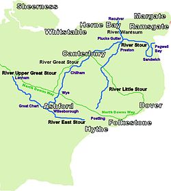
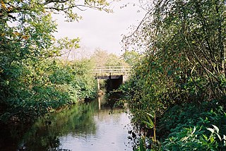
The River Stour(, rhymes with "flour") is a river in Kent, England that flows into the North Sea at Pegwell Bay. Above Plucks Gutter, where the Little Stour joins it, the river is normally known as the Great Stour. The upper section of the river, above its confluence with the East Stour at Ashford is sometimes known as the Upper Great Stour or West Stour. In the tidal lower reaches, the artificial Stonar Cut short cuts a large loop in the natural river.

<span class="mw-page-title-main">River Stour, Dorset</span> River in Dorset, England

The River Stour is a 61 mi (98 km) river which flows through Wiltshire and Dorset in southern England, and drains into the English Channel. The catchment area for the river and its tributaries is listed as 480 square miles (1,240 km2).

<span class="mw-page-title-main">River Stour, Worcestershire</span> River in the West Midlands, England

The Stour(, rhymes with "flour") is a river flowing through the counties of Worcestershire, the West Midlands and Staffordshire in the West Midlands region of England. The Stour is a major tributary of the River Severn, and it is about 25 miles (40 km) in length. It has played a considerable part in the economic history of the region.

<span class="mw-page-title-main">River Rother, South Yorkshire</span> River in South Yorkshire, England

The River Rother, a waterway in the northern midlands of England, gives its name to the town of Rotherham and to the Rother Valley parliamentary constituency. It rises in Pilsley in Derbyshire and flows in a generally northwards direction through the centre of Chesterfield, where it feeds the Chesterfield Canal, and on through the Rother Valley Country Park and several districts of Sheffield before joining the River Don at Rotherham in Yorkshire. Historically, it powered mills, mainly corn or flour mills, but most had ceased to operate by the early 20th century, and few of the mill buildings survive.

<span class="mw-page-title-main">City of Canterbury</span> Local government district in Kent, England

Canterbury, commonly called the City of Canterbury, is a local government district with city status in Kent, England. As well as Canterbury itself, the district extends north to the coastal towns of Whistable and Herne Bay.

<span class="mw-page-title-main">Rivers of Kent</span>

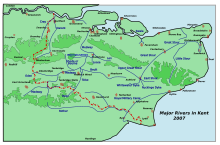
Four major rivers drain the county of Kent, England.

<span class="mw-page-title-main">Foudry Brook</span> River in Hampshire and Berkshire, England

Foudry Brook is a small stream in southern England. It rises from a number of springs near the Hampshire village of Baughurst, and flows to the east and then the north, to join the River Kennet to the south of Reading. The upper section is called Silchester Brook, and beyond that, Bishop's Wood Stream. The underlying geology is chalk, covered by a layer of clay, and so it has the characteristics of a clay stream, experiencing rapid increases in level after heavy rain due to run-off from the surrounding land. It passes a number of listed buildings and scheduled monuments, including the site of the Roman town of Calleva Atrebatum or Silchester.

<span class="mw-page-title-main">Noonday Creek</span>

Noonday Creek is a 20.2-mile-long (32.5 km) stream in Cobb and Cherokee counties in the U.S. state of Georgia. The stream begins near Kennesaw Mountain and ends at Lake Allatoona.

<span class="mw-page-title-main">Etchinghill, Kent</span> Human settlement in England

Etchinghill is a village in Kent, England, about 5 km north of Hythe, and 1 km north of the Channel Tunnel terminal at Cheriton, near Folkestone. It is in the civil parish of Lyminge.

<span class="mw-page-title-main">Barham, Kent</span> Human settlement in England

Barham is a village and civil parish in the City of Canterbury district of Kent, England. Barham village is approximately 6 miles (10 km) south-east from Canterbury and 8 miles (13 km) north from Folkestone.

<span class="mw-page-title-main">Lyminge</span> Human settlement in England

Lyminge is a village in southeast Kent, England. It lies about five miles (8 km) from Folkestone and the Channel Tunnel, on the road passing through the Elham Valley. At the 2011 Census the population of Etchinghill was included. The Nailbourne stream begins in the village and flows north through the Valley, to become one of the tributary streams of the Great Stour. The hamlet of Ottinge lies to the NE on the road to Elham. Lyminge is home to the Grade II* listed Sibton Park, now owned by the Holiday Property Bond but previously a school.

<span class="mw-page-title-main">Stour Valley Walk</span> Recreational walking route in England

The Stour Valley Walk is a recreational walking route that follows the River Stour, through the Low Weald and Kent Downs, from its source at Lenham to its estuary at Pegwell Bay.

PUB, Singapore's National Water Agency, commonly known as PUB, an acronym for Public Utilities Board, is a statutory board under the Ministry of Sustainability and the Environment of the Government of Singapore responsible for ensuring a sustainable and efficient water supply in Singapore.

<span class="mw-page-title-main">Rawa (river)</span> River in Poland

Rawa is a minor river in Silesia, Poland. It is the largest right tributary of the Brynica, itself a tributary of the Przemsza, which in turn is a tributary of the Vistula. The entire length of the Rawa is within the Upper Silesian Metropolitan Union. It has its source in Ruda Śląska and crosses the cities of Świętochłowice, Chorzów and Katowice. Finally in Sosnowiec it joins the Brynica River only several hundred metres before the latter joins with Czarna Przemsza.

<span class="mw-page-title-main">Elham Valley Railway</span> Former railway in England, now closed.

The Elham Valley Railway was a line connecting Folkestone and Canterbury in Kent, England. It opened between 1887 and 1889 and closed in 1947.

<span class="mw-page-title-main">Stour watermills</span>

The River Stour has been used for centuries as a source of power. Many different processes were performed by the use of water power:- Corn milling, fulling, paper making and electricity generation. Many of the mills survive today as house conversions, with two of them still working commercially.

The Smestow Brook, sometimes called the River Smestow, is a small river that plays an important part in the drainage of Wolverhampton, South Staffordshire, and parts of Dudley in the United Kingdom, and has contributed to the industrial development of the Black Country. It is the most important tributary of the River Stour, Worcestershire and part of the River Severn catchment.

<span class="mw-page-title-main">The Cut, Berkshire</span> River in Berkshire, England

The Cut is a river in England that rises in North Ascot, Berkshire. It flows for around 14 miles (23 km), through the rural Northern Parishes of Winkfield, Warfield and Binfield in Bracknell Forest on its way down to Bray, where it meets the River Thames just above Queens Eyot on the reach below Bray Lock, having been joined by the Maidenhead Waterways.

<span class="mw-page-title-main">Stodmarsh SSSI</span>

Stodmarsh SSSI is a 623.2-hectare (1,540-acre) biological Site of Special Scientific Interest near Stodmarsh, north-east of Canterbury in Kent. Parts of it are a Nature Conservation Review site, Grade I, a National Nature Reserve, a Ramsar internationally important wetland site, a Special Area of Conservation and a Special Protection Area under the European Union Directive on the Conservation of Wild Birds.

References

  1. Joseph, Priestley (1831). Historical Account of the Navigable Rivers, Canals and Railways of Great Britain. London: Longman, Rees, Orme, Brown and Green. pp.  131–137. Retrieved 15 March 2010. river stour priestley 1831.
  2. "Places - Riddley Walker Annotations". Errorbar. Archived from the original on 29 July 2021. Retrieved 21 August 2022.
  3. "Little Stour ward population 2011" . Retrieved 2 October 2015.


51°19′30″N1°15′11″E / 51.3250°N 1.2530°E / 51.3250; 1.2530