
Medway is a unitary authority area with borough status in the ceremonial county of Kent in South East England. It was formed in 1998 by merging the boroughs of Rochester-upon-Medway and Gillingham, and is administered by Medway Council, which is independent from Kent County Council. The borough had a population of 278,016 in 2019. The borough contains the towns of Chatham, Gillingham, Rainham, Rochester and Strood, which are collectively known as the Medway Towns.

Rainham is a town in the unitary authority area of Medway, in the ceremonial county of Kent, England. The town forms a conurbation with neighbouring towns Chatham, Rochester, Strood and Gillingham.

Kemsing is a village and civil parish in the Sevenoaks district of Kent, England. The parish lies on the scarp face of the North Downs, 20 miles south east of Central London and 4 miles (6 km) north east of Sevenoaks. Also in the parish there are the hamlets of Heaverham, 1 mile (2 km) to the east and Noah's Ark 0.5 miles (1 km) to the south. The population of the civil parish in 2001 was 4,014 persons, increasing to a population of 4,218 at the 2011 Census.
Southfleet is a small village and civil parish in the borough of Dartford in Kent, England. The village is located three miles southwest of Gravesend, while the parish includes within its boundaries the hamlets of Betsham and Westwood.

Bekesbourne railway station is on the Dover branch of the Chatham Main Line in England, and serves the villages of Bekesbourne and Patrixbourne, Kent. It is 64 miles 58 chains (104.2 km) down the line from London Victoria and is situated between Canterbury East and Adisham.

Barham is a village and civil parish in the City of Canterbury district of Kent, England. Barham village is approximately 6 miles (10 km) south-east from Canterbury and 8 miles (13 km) north from Folkestone.
Bekesbourne-with-Patrixbourne is a civil parish in the City of Canterbury district of Kent, England. It is located 4 miles south-east of Canterbury.
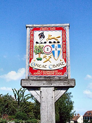
Great Chart is a village and former civil parish, now in the parish of Great Chart with Singleton, in the Ashford borough of Kent, England. The parish is split between the ancient village of Great Chart and the modern Singleton neighbourhood on the western outskirts of Ashford. The village centre of Great Chart is 2 miles (3.2 km) from the town centre. In 1961 the parish had a population of 969.

Rolvenden is a village and civil parish in the Ashford District of Kent, England. The village is centred on the A28 Ashford to Hastings road, 5 miles (8.0 km) south-west of Tenterden.

Chestfield is a village in the Canterbury District of Kent, England. The parish is centred 0.5 miles (0.80 km) from the sea on the north coast of Kent, between the towns of Whitstable and Herne Bay. It is approximately five miles (8 km) north of Canterbury. Over a third of the parish, all of which is the south of its ambit, is woodland. The north-west consists of a business park and superstore.

Newington is a village and civil parish in the borough of Swale in Kent, England. The parish is located beside the A2 road between Rainham to the west and Sittingbourne to the east. The population of the parish in 2011 was 2,551.

Patrixbourne is a village and former civil parish, now in the parish of Bekesbourne-with-Patrixbourne, in the Canterbury district in Kent, England. It is 3 miles (5 km) south-east of Canterbury. It is mostly taken up by agricultural hills and along with almost contiguous Bekesbourne. In 1931 the parish had a population of 245.

Littlebourne is a village and civil parish 4 miles (6.4 km) east of Canterbury in Kent, South East England.

Guston is a village and civil parish in the Dover district of Kent, in South East England. The village lies about a quarter of a mile north of the campus of the Duke of York's Royal Military School, near Martin Mill. In the 1950s the village was the site of a public house, a post office, a Saxon church and approximately one-hundred homes. There is also a windmill present, which has been converted into a house. Nearby villages include Whitfield, East Langdon, Pineham and Buckland. The River Dour is approximately 2.71 km away from Guston, and there is easy access to main roads, with the A2 and A258 running around and through the village.

Thanington is a civil parish on the west edge of Canterbury, Kent, United Kingdom. It extends to the south-west of A2 from Wincheap to the Milton Bridge in Chartham. In 2011 the parish had a population of 2662.

Chelsfield is an area in southeast London, England, within the London Borough of Bromley and, prior to 1965, in the historic county of Kent. It lies south of Goddington, west of Well Hill, north of Pratt's Bottom and east of Green Street Green. The area is split into two distinct areas – the historic 'village' section, and the newer development by the railway station.

Seasalter is a village in the Canterbury district of Kent, England. Seasalter is on the north coast of Kent, between the towns of Whitstable and Faversham, facing the Isle of Sheppey across the estuary of the River Swale. The settlement of Yorkletts is included in the ward. It is approximately 6 miles (10 km) north of Canterbury.

Norton, Buckland and Stone is a small rural civil parish 1 mile (1.6 km) east of Teynham and 3 miles (4.8 km) west of the centre of Faversham in the borough of Swale, Kent, England. It is bypassed by the M2 to the south and traverses the historic A2, on the route of the Roman road of Watling Street. In 2011 the parish had a population of 467.

Bekesbourne Aerodrome was an airport located at the southeast edge of the village of Bekesbourne, southeast of Canterbury, Kent. It operated from 1916 until 1940, and had both military and civil roles.

Denton with Wootton is a civil parish in the Dover District of Kent, England. The parish contains the settlements of Denton and Wootton, 1 mile (1.6 km) apart. In 2011 it had a population of 372.


