Herne Bay is a seaside town on the north coast of Kent in South East England. It is 6 miles (10 km) north of Canterbury and 4 miles (6 km) east of Whitstable. It neighbours the ancient villages of Herne and Reculver and is part of the City of Canterbury local government district, although it remains a separate town with countryside between it and Canterbury. Herne Bay's seafront is home to the world's first freestanding purpose-built Clock Tower, built in 1837. From the late Victorian period until 1978, the town had the second-longest pier in the United Kingdom.

Reculver is a village and coastal resort about 3 miles (5 km) east of Herne Bay on the north coast of Kent in south-east England. It is in the ward of the same name, in the City of Canterbury district of Kent.

Sturry is a village on the Great Stour river situated 3 miles (4.8 km) northeast of Canterbury in Kent. Its large civil parish incorporates several hamlets and, until April 2019, the former mining village of Hersden.

Thanet is a local government district in Kent, England. The council is based in Margate and the district also contains the towns of Broadstairs, Ramsgate and Westgate-on-Sea, along with several villages. It takes its name from the Isle of Thanet, a former island which gradually became connected to the mainland between the 12th and 16th centuries.

Birchington-on-Sea is a village in the Thanet district in Kent, England, with a population of 9,961.
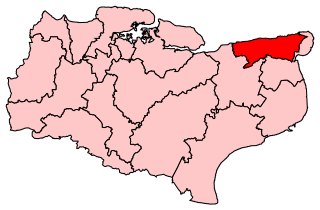
North Thanet was a constituency in Kent. It was represented in the House of Commons of the UK Parliament since its 1983 creation until abolition by Sir Roger Gale, a Conservative.

Broomfield is a village and residential suburb in the City of Chelmsford district, immediately north of the city itself. It is the site of a major Accident & Emergency hospital. There are two public houses as well as primary and secondary schools and sports clubs.

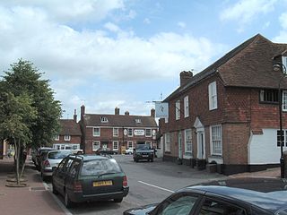
Harrietsham is a rural and industrial village and civil parish in the Maidstone District of Kent, England noted in the Domesday Book. According to the United Kingdom Census 2001, it had a population of 1,504, increasing to 2,113 at the 2011 Census. The parish is in the North Downs, 7 miles (10 km) east of Maidstone and includes the settlements of Marley, Pollhill and Fairbourne.
Herne and Broomfield is a civil parish and electoral ward within the City of Canterbury. The parish is situated to the north of Canterbury in Kent. The seaside town of Herne Bay is the other side of the A299 road, Thanet Way that marks the northern boundary of the parish. Greenhill, part of Herne Bay, lies to the west, the parishes of Hoath and Chislet are to the east and Sturry parish is to the South.
Broomfield and Kingswood is a civil parish in the Maidstone district of Kent, England. The parish lies to the east of Maidstone, south of the A20 road to Folkestone. According to the 2001 census it had a population of 1,545, increasing to 1,604 at the 2011 Census. The parish covers the villages of Broomfield and Kingswood.

Sedgeford is a village and civil parish in the English county of Norfolk, about 5 miles south of the North Sea and 3 miles (4.8 km) east of the Wash. It is 36 miles northwest of Norwich.
Rotherfield is a village and civil parish in the Wealden District of East Sussex, England. It is one of the largest parishes in East Sussex. There are three villages in the parish: Rotherfield, Mark Cross and Eridge. The River Rother, which drains much of the county and discharges at Rye Harbour, has its source on the south side of the hill on which Rotherfield village is built.
Broomfield is a village in the Maidstone District of Kent, England, and forms part of the civil parish of Broomfield and Kingswood. It lies 6 miles (10 km) to the east of Maidstone. The village is located just upstream of Leeds Castle on the River Len, one of the tributaries of the River Medway.

Whitley is a civil parish in the unitary authority of Cheshire West and Chester and the ceremonial county of Cheshire, England. It is surrounded by the parishes of Antrobus, Comberbach, Little Leigh and Dutton. It also borders Daresbury in Halton borough as well as Hatton and Stretton in Warrington borough. It is a small village located next to Antrobus.

Hothfield is a village and civil parish in the Ashford Borough of Kent, England and is 3 miles north-west of Ashford on the A20. It is completely split in two by Hothfield Common.

Chestfield is a village in the Canterbury District of Kent, England. The parish is centred 0.5 miles (0.80 km) from the sea on the north coast of Kent, between the towns of Whitstable and Herne Bay. It is approximately five miles (8 km) north of Canterbury. Over a third of the parish, all of which is the south of its ambit, is woodland. The north-west consists of a business park and superstore.

Herne is a village in the civil parish of Herne and Broomfield, in Canterbury district, in the county of Kent, England. It is divided by the Thanet Way from the seaside resort of Herne Bay. Between Herne and Broomfield, is the former hamlet of Hunters Forstal. Herne Common lies to the south on the A291 road.

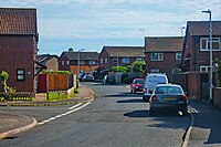
Eddington was a village in Kent, South East England to the south-east of Herne Bay, to the west of Beltinge and to the north of Herne. It is now a suburb of Herne Bay, in Greenhill and Eddington Ward, one of the five wards of Herne Bay. Its main landmark for over 100 years until 2010 was Herne Bay Court, a former school which once possessed one of the largest and best-equipped school engineering workshops in England; it later became a Christian conference centre.

Ilketshall St Lawrence is a village and civil parish in the East Suffolk district of the English county of Suffolk. It is 3 miles (4.8 km) south-east of the market town of Bungay and is part of a group of parishes with similar names known collectively as the Saints.
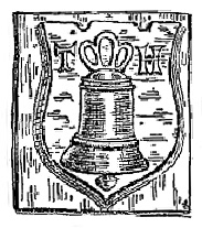
The Hatch bell foundry at Ulcombe, near Maidstone, in Kent, England, was operated by three generations of the Hatch family from 1581 or earlier until 1664. The bellfounders were based at nearby Broomfield from about 1587 until at least 1639. Joseph Hatch, bellfounder from 1602 to 1639, cast at least 155 bells, including "Bell Harry", after which the central tower of Canterbury Cathedral is named. Most Hatch bells were used in churches east of the River Medway in East Kent.