Wincheap

Last updated • 3 min readFrom Wikipedia, The Free Encyclopedia

Wincheap
Wincheap, looking towards the railway bridge - geograph.org.uk - 746919.jpg
Kent UK location map.svg
Red pog.svg
Wincheap
Location within Kent
Population9,095 (Ward 2011) [1]
District
Shire county
Region
Country England
Sovereign state United Kingdom
Post town Canterbury
Postcode district CT1
Police Kent
Fire Kent
Ambulance South East Coast
List of places
UK
England
Kent
51°16′23″N1°04′13″E / 51.2730°N 1.0704°E / 51.2730; 1.0704

Wincheap is a road and suburb in Canterbury, Kent, England. The road forms part of the A28 road, stretching for around 1 mile (1.6 km) from the city wall, close by Canterbury East railway station, to the over-crossing of the A2 and the parish of Thanington.

Contents

History

There are two theories about the name: either it comes from the Saxon Wenchiape, a wine market, or from Weychep from the old English Waegnceap, indicating a wagon market. [2]

Wincheap originated as an ancient trackway to the east of the River Stour. In Roman Britain it was used for communication between Canterbury and the iron works in the Weald. [2] The modern street was established by the early 13th century; the name is recorded starting in 1226. [3] Wincheap Gate, since demolished, was one of the entrances in the city walls. [4] A timber market was held halfway along Wincheap in the 13th century, while an annual cherry fair took place on Wincheap Green until the early 19th century. The green was destroyed during construction of the Canterbury Ring Road in the 1960s. [2]

Since 1996, most of Wincheap from the railway bridge to the A2 bypass has been marked as a conservation area by the city council. [5] There is a petrol station halfway along the road, which has been criticised for having a negative effect on the area. [6] At the end of 2021, the council announced plans to make Wincheap one-way southbound, sending northbound traffic via a different route. [7]

Properties

The King's Head The King's Head Public House, Canterbury - geograph.org.uk - 1801027.jpg
The King's Head

Nos. 50–52 were constructed in the 18th century and were originally a single house. They are three storeys high and constructed of red brick. They were Grade II listed in 1973. [8]

Wincheap House at No. 74 was constructed in the 16th century. Originally a timber-framed building, it was extensively rebuilt in the 18th century, though the overhang of the top two floors was retained, as was the 16-panelled front door. The premises was Grade II listed in 1949. [9]

Nos. 96–116 date from the early 18th century, and are a group of two-storey brick houses that are a mixture of painted, stuccoed and roughcast, included hipped tiled roofs. They were Grade II listed in 1973. [10]

Nos. 160–164 are a terrace of early 19th century red brick houses. No. 160 has a more decorative door than the others. The terrace was Grade II listed in 1973. [11]

The Thanington Hotel is at No. 140. It dates from the early 19th century and is a three-storey building rendered with cement. It was Grade II listed in 1967 along with Nos. 126–136. [12] [13]

The King's Head Inn at Nos. 198–204 Wincheap was established around the early 15th century and was believed to be the city's oldest continuously trading inn. [14] The timber-framed exterior was re-fronted in the 18th century, preserving the overhang of the first floor. The building includes a tile-hung rear elevation. It was Grade II listed in 1967. [14] [15] The pub closed in May 2022. [16]

Wincheap House Canterbury - Wincheap House.jpg
Wincheap House

The Wincheap Non-Conformist Burial Ground sits alongside the King's Head on the west side of Wincheap. It was established in 1849 and contains 281 graves; the last burial occurred in 1962. It was restored in 1997 and financed by the National Lottery Heritage Fund. [6]

Nos. 268–274 form a terrace of red brick houses. They were constructed in 1771. [5]

The Hospital of St James by Canterbury was based at the southern edge of Wincheap where the road meets Thanington. It was established in the 12th century for female lepers, and maintained by three priests. It survived the dissolution of similar hospitals during the reign of Henry VIII, and closed on 28 February 1551 under the reign of Edward VI. All premises and all possessions were surrendered to the crown. [17] [18]

The Thanington Pumping Station was based at the edge of the conservation area at the southeast part of Wincheap. It opened in 1869 and was designed by Samuel Collett Homersham. It was demolished in the 1990s and replaced with a small retail park. [5]

A telephone box at the north end of Wincheap by the railway bridge was Grade II listed in 1989. It was built in 1935 by Sir Giles Gilbert Scott and constructed from cast iron. [19]

Related Research Articles

<span class="mw-page-title-main">A28 road</span> Trunk road in Kent and East Sussex

The A28 is a trunk road in the counties of Kent and East Sussex in south east England, connecting Margate, Canterbury, Ashford and Hastings.

<span class="mw-page-title-main">Chartham</span> Village and civil parish in Kent, England

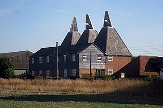
Chartham is a village and civil parish in the Canterbury district of Kent, England. It is situated on the Ashford side of the city, and is in the North Downs area of Outstanding Natural Beauty, 2.3 mi (4 km) south west of Canterbury, England. The Great Stour Way path passes through the village. A paper mill in the village that had specialised in the production of tracing paper since 1938 has in 2022 closed down. There are numerous arable farms and orchards in the parish. The village has an unstaffed station, Chartham, and has recently upgraded its staffed level crossing to an automatic barrier. It has an outlying locality sharing in many of the community resources, Chartham Hatch. Its current

<span class="mw-page-title-main">Nonington</span> Human settlement in England

Nonington, is a civil parish and village in east Kent, halfway between the historic city of Canterbury and the channel port town of Dover. The civil parish includes the hamlets of Easole Street, to which it is conjoined, Holt Street and Frogham. The 2021 census gives the population of the parish as 920. The area of the parish at 31 December 2020 is 2,510 acres (1,020 ha).

<span class="mw-page-title-main">Iwade</span> Human settlement in England

Iwade is a village and civil parish 2 miles (3.2 km) north of the town of Sittingbourne in the English county of Kent.

<span class="mw-page-title-main">Rolvenden</span> Village in Kent, England

Rolvenden is a village and civil parish in the Ashford District of Kent, England. The village is centred on the A28 Ashford to Hastings road, 5 miles (8.0 km) south-west of Tenterden.

<span class="mw-page-title-main">Teynham</span> Human settlement in England

Teynham is a large village and civil parish in the borough of Swale in Kent, England. The parish lies between the towns of Sittingbourne and Faversham, immediately north of the A2 road, and includes the hamlet of Conyer on an inlet of the Swale, the channel that separates mainland Kent from the Isle of Sheppey. Other hamlets include Deerton Street, Frognal, and Teynham Street.

<span class="mw-page-title-main">Thanington</span> Human settlement in England

Thanington is a civil parish on the west edge of Canterbury, Kent, United Kingdom. It extends to the south-west of A2 from Wincheap to the Milton Bridge in Chartham. In 2011 the parish had a population of 2662.

<span class="mw-page-title-main">Bredgar</span> Human settlement in England

Bredgar is a village and civil parish in the Borough of Swale, Kent, England.

<span class="mw-page-title-main">Sheldwich</span> Human settlement in England

Sheldwich is a village and civil parish in the far south of the Borough of Swale in Kent, England.

<span class="mw-page-title-main">Selling, Kent</span> Human settlement in England

Selling is a village and civil parish southeast of Faversham and west of Canterbury in Kent, England.

Marshborough is a small hamlet immediately adjacent to Woodnesborough in East Kent, England.

<span class="mw-page-title-main">Centuries, Hythe</span> House in Hythe, Kent, UK

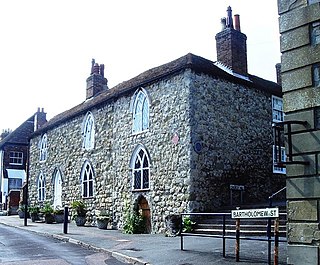
Centuries is a house in Hythe, Kent, built in the 13th century, possibly earlier. It is the birthplace of Hamo Hethe, b.1275, who became the Bishop of Rochester in 1319. In 1685 it became St. Bartholomew's Hospital, for between ten and thirteen people, until 1949; from 1951 it has been divided into two private flats. The house is currently listed on the Statutory List of Buildings of Special Architectural or Historic Interest as Grade II*, and is on the corner of Church Hill and Bartholomew Street in Hythe.

<span class="mw-page-title-main">Archbishop's Palace, Maidstone</span>

The Archbishop's Palace is a Grade I listed historic 14th-century and 16th-century building on the east bank of the River Medway in Maidstone, Kent. Originally a home from home for travelling archbishops from Canterbury, the building has been most recently used as a venue for wedding services. The former tithe barn for the palace, now serves as the Tyrwhitt-Drake Museum of Carriages.

<span class="mw-page-title-main">Royal Crescent, Brighton</span> Historic site in East Sussex , England

Royal Crescent is a crescent-shaped terrace of houses on the seafront in Brighton, part of the English city of Brighton and Hove. Built in the late 18th and early 19th century as a speculative development on the open cliffs east of Brighton by a wealthy merchant, the 14 lodging houses formed the town's eastern boundary until about 1820. It was the seaside resort's first planned architectural composition, and the first built intentionally to face the sea. The variety of building materials used include black glazed mathematical tiles—a characteristic feature of Brighton's 18th-century architecture. English Heritage has listed the crescent at Grade II* for its architectural and historical importance. An adjacent five-storey building, formerly the Royal Crescent Hotel but now converted into flats with the name Royal Crescent Mansions, is listed separately at Grade II.

<span class="mw-page-title-main">Smiths Hall</span>

Smiths Hall, known as West Farleigh Hall from the early 20th century until the 1990s, is an 18th-century country house in West Farleigh, Kent.

<span class="mw-page-title-main">Hasfield</span> Human settlement in England

Hasfield is a civil parish in Gloucestershire, England, and lies six miles (9.7 km) south-west of Tewkesbury and seven miles (11 km) north of Gloucester. It is situated on the west bank of the River Severn; as much of its land resides below the 50-foot contour, it is subject to regular flooding. Hasfield is represented by the county councillor for Severn Vale division and the two borough councillors for Highnam with Haw Bridge ward on Tewkesbury Borough Council.

<span class="mw-page-title-main">Norton, Buckland and Stone</span> Human settlement in England

Norton, Buckland and Stone is a small rural civil parish 1 mile (1.6 km) east of Teynham and 3 miles (4.8 km) west of the centre of Faversham in the borough of Swale, Kent, England. It is bypassed by the M2 to the south and traverses the historic A2, on the route of the Roman road of Watling Street.

<span class="mw-page-title-main">Church of St Mary, Chartham</span> Church in Kent, England

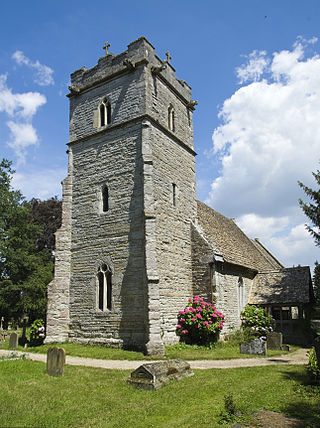
St Mary's Church is in the village of Chartham, Kent, England. It is an active Anglican parish church in the Diocese of Canterbury. Constructed between 1285 and circa 1305, with a later tower of the fourteenth century. In 1875, the church was restored by George Edmund Street. St Marys is designated by English Heritage as a Grade I listed building.

<span class="mw-page-title-main">Godmersham Park</span> House in Kent, United Kingdom

Godmersham Park is a Grade I listed house in Godmersham in the English county of Kent. The house is on the edge of the North Downs between Ashford and Canterbury. It has associations with the writer Jane Austen, and is depicted on the new Bank of England £10 note issued in 2017. It is now home to the Association of British Dispensing Opticians.

<span class="mw-page-title-main">Church of St Peter and St Paul, Trottiscliffe</span> Church in Trottiscliffe, England

The Church of St Peter and St Paul is an active Anglican parish church in Church Lane, Trottiscliffe, in the Borough of Tonbridge and Malling, Kent, England. It is situated below the North Downs on the lowest levels of the Lower Chalk, above a spring on the Gault clay top at approximately 280 feet above ordnance datum.

References

Citations

  1. "Canterbury Ward population 2011". Neighbourhood Statistics. Office for National Statistics. Retrieved 11 September 2016.
  2. 1 2 3 Canterbury 2010, p. 116.
  3. Johannes Knut Wallenberg (1931). Kentish Place-names: A Topographical and Etymological Study of the Place-Name Material in Kentish Charters Dated Before the Conquest. Upsala universitets årsskrift. Vol. 1931:2. Uppsala: Lundequist. p. 5.
  4. Henry Boswell (1795). The Antiquities of England and Wales Displayed. London: Hogg. OCLC   221287121.
  5. 1 2 3 Canterbury 2010, p. 118.
  6. 1 2 Canterbury 2010, p. 119.
  7. "Major Canterbury route A28 in Wincheap will be one-way". Kent Online. 12 December 2021. Retrieved 12 December 2021.
  8. Historic England. "Details from listed building database (1242989)". National Heritage List for England . Retrieved 25 February 2020.
  9. Historic England. "Details from listed building database (1258047)". National Heritage List for England . Retrieved 23 February 2020.
  10. Historic England. "Details from listed building database (1258048)". National Heritage List for England . Retrieved 23 February 2020.
  11. Historic England. "Details from listed building database (1258052)". National Heritage List for England . Retrieved 23 February 2020.
  12. Canterbury 2010, p. 120.
  13. Historic England. "Details from listed building database (1258050)". National Heritage List for England . Retrieved 23 February 2020.
  14. 1 2 "The great debate: What is Canterbury's oldest pub?". Canterbury Journal. 14 July 2018. Retrieved 23 February 2020.
  15. Historic England. "Details from listed building database (1258059)". National Heritage List for England . Retrieved 23 February 2020.
  16. "Old favourites remain closed". Kentish Gazette. 14 July 2022. Retrieved 19 January 2024.
  17. 'Hospitals: Hospitals in and around Canterbury', in A History of the County of Kent: Volume 2, ed. William Page (London, 1926), pp. 209–216. British History Online http://www.british-history.ac.uk/vch/kent/vol2/pp209-216 [accessed 23 February 2020].
  18. Edward Hasted, 'Parishes: Thanington', in The History and Topographical Survey of the County of Kent: Volume 9 (Canterbury, 1800), pp. 21–27. British History Online http://www.british-history.ac.uk/survey-kent/vol9/pp21-27 [accessed 23 February 2020].
  19. Historic England. "Details from listed building database (1258428)". National Heritage List for England . Retrieved 23 February 2020.

Sources