Chartham

Last updated • 6 min readFrom Wikipedia, The Free Encyclopedia

Chartham
Village Church, Chartham - geograph.org.uk - 663007.jpg
St Mary's Church with part of the Green
Hoppers Oast, Hatch Lane, Chartham Hatch, Kent - geograph.org.uk - 1501876.jpg
Chartham Hatch
Kent UK location map.svg
Red pog.svg
Chartham
Location within Kent
Area20.84 km2 (8.05 sq mi)
Population4,261 (Civil Parish 2011) [1]
  Density 204/km2 (530/sq mi)
OS grid reference TR108549
Civil parish
  • Chartham
District
Shire county
Region
Country England
Sovereign state United Kingdom
Post town Canterbury
Postcode district CT4
Dialling code 01227
Police Kent
Fire Kent
Ambulance South East Coast
UK Parliament
List of places
UK
England
Kent
51°15′52″N1°02′28″E / 51.2645°N 1.0410°E / 51.2645; 1.0410

Chartham is a village and civil parish in the Canterbury district of Kent, England. It is situated on the Ashford side of the city, and is in the North Downs area of Outstanding Natural Beauty, 2.3 mi (4 km) south west of Canterbury, England. The Great Stour Way path passes through the village. A paper mill in the village that had specialised in the production of tracing paper since 1938 [2] has in 2022 closed down. There are numerous arable farms and orchards in the parish. The village has an unstaffed station, Chartham, and has recently upgraded its staffed level crossing to an automatic barrier. It has an outlying locality sharing in many of the community resources, Chartham Hatch. Its current Lord Mayor is Gary Dodd.[ when? ]

Contents

Nearby communities are Harbledown and Rough Common, Blean, and to the north Thanington.

History

Toponymy

The earliest recorded form of the name is Certham. The name Chartham literally means 'Village on rough ground', and the word "Chart" is also found in other villages in Kent with this meaning. The Stone Street part of the name comes from Stone Street, a road and small hamlet that runs parallel to the A28 on the other side of the villages.

Modern day

The river provided power for the paper mills until some point before 1955. Paper making has been a major occupation for the last 625 years; the mill dates from the late eighteenth century.

The dovecote at Burnt House Farm is not only notable for its building's architectural merit but is also a Scheduled Ancient Monument for its importance in sending homing birds to and from important envoys such as the Archbishop of Canterbury. [3]

Geography and economy

Chartham is located on the Great Stour river scattered along the Ashford Road in Canterbury and on the vale of the Kent Downs Area of Outstanding Natural Beauty. Its paper mill specialises in the production of tracing paper. There are numerous arable farms and orchards in the parish.

The village is served by Chartham railway station which is one stop westbound from Canterbury West station on the high speed line to London, although high speed services do not stop here. Chartham is also on the western end of the 3-mile Great Stour Way cycle path to Canterbury City Centre. [4]

Being in such close proximity to the city, the village's economy is closely tied to Canterbury. Aside from this, there are several village stores, two pubs, a small venue (Chartham Village Hall in Station Road) and a vineyard.

Governance

At the national level Chartham is in the parliamentary constituency of Canterbury for which Rosie Duffield (Labour) has been MP since 2017. Prior to Brexit in 2020 for European elections Chartham was in the South East England constituency.

Chartham is also part of the electoral ward called Chartham and Stone Street. The population of this ward at the 2011 Census was 5,878. [5]

Demography

In the census of 1801 the number of people present in the parish of Chartham, enclosing an area of about 3 square miles (8 km2) and including the settlement of Chartham Hatch, was given as 776, and this figure remained roughly stable until the late 19th century when a dramatic increase was recorded: in the census of 1881, the number was given as 2,473. [6]

Railway Station

Chartham railway station lies one stop west of Canterbury West and has regular trains to London Charing Cross railway station. The HS1 trains to St Pancras also pass through the station but do not stop here.

Landmarks

Church

The Church of St Mary is located next to the village green and contains six bells, five of which were made by Joseph Hatch in 1605, which makes the bells the oldest complete set by the same bellfounder in Kent. [7] [8] It was built in approximately 1294 and features a number of brasses, including that of Sir Robert de Setvans (d 1306). The stonework of its chancel windows exhibit a form of tracery, known as Kentish or split cusp tracery, which originates here. [8] [9] The tower is 14th century and the renovation was in 1875 by Oxford University architect George Edmund Street. [10]

Outlying areas

Shalmsford Street

The village is contiguous with the smaller Shalmsford Street to the west, and was until recently the location of St Augustine's Mental Hospital, formerly known as the East Kent Lunatic Asylum. The site on which St Augustine's stood has now become a housing estate.

The village's post office was at 105 Shalmsford Street, but is now located at 14B Godfrey Gardens in the Chartham Downs housing area. [11] In Shalmsford Street is also Chartham Primary School, in which Chartham Parish meetings are held. [12]

Chartham Hatch

Chartham Hatch is the northern upper part of the village, also known as a hamlet, of approximately 200 houses. It is surrounded by small woods and its orchards of apples and pears. Village Hall, formerly the school, is in the centre. The famous North Downs Way passes through the village.

Horton

Horton or Horton Manor is a tiny hamlet northeast by the Great Stour Way with its weir, Grade II listed manor house, [13] and scheduled ancient monument manor chapel remains, later which became an oast house and agricultural storage area. [14] In 844 King Æthelwulf of Wessex granted land at Horton to Ealdorman Eadred. A translation of the text of Charter S 319 reads: "Bounds of Horton. On the east: the wood which is called down-grove. On the west: the [arch]bishop and Lulla jointly. On the southern side: the land of Lulla at Chartham. On the north: the land of Beornwulf, which he possesses in eternity." [15]

Mystole House Mystole House - geograph.org.uk - 404347.jpg
Mystole House

Mystole and Thruxted

These hamlets are south west along the Great Stour and to the south east. Mystole is rich in heritage due to its focal point, Mystole House, a 16th-century historic building, with architectural Grade II* status [16] and former appurtenances/outbuildings: Grade II* listed Mystole Coach House; [17] its Park; listed orangery; [18] tennis court; Archway Lodge; [19] The Tetherings [20] and Stable House. Thruxted itself has a large working farmhouse. [21]

Chartham Downs

Built on the ground of the former mental asylum hospital, and sharing the name of the hospital, Chartham Downs is a large housing area to the north-east of the village. It encompasses a local shop (incorporating the village post office), football/cricket grounds and three children's play parks. It lies on the North Downs Way, and is closer to Street End, Nackington and Thanington than to the opposite end of Chartham. This fact means that the estate whilst being part of Chartham in a political aspect, is in many ways cut off from the village. In 1997 development of the site for housing was begun. A few of the hospital buildings, including the administration block, the water tower, and the chapel, were retained but the rest were demolished. Although Canterbury City Council suggested that "a change of name would help in creating a new sense of identity", the site is known as St Augustine's Estate, however signs refer to the area as ‘Chartham Downs’.

Related Research Articles

<span class="mw-page-title-main">River Stour, Kent</span> River in England

The River Stour is a river in Kent, England that flows into the North Sea at Pegwell Bay. Above Plucks Gutter, where the Little Stour joins it, the river is normally known as the Great Stour. The upper section of the river, above its confluence with the East Stour at Ashford is sometimes known as the Upper Great Stour or West Stour. In the tidal lower reaches, the artificial Stonar Cut short cuts a large loop in the natural river.

<span class="mw-page-title-main">Wye, Kent</span> Human settlement in England

Wye is a village and former civil parish, now in the parish of Wye with Hinxhill, in the Ashford district, in Kent, England, 5 miles (8.0 km) from Ashford and 12 miles (19 km) from Canterbury. It is the main settlement in the parish of Wye with Hinxhill. Hop varieties including Wye Challenger were bred at Wye College and named for the village.

<span class="mw-page-title-main">A28 road</span> Trunk road in Kent and East Sussex

The A28 is a trunk road in the counties of Kent and East Sussex in south east England, connecting Margate, Canterbury, Ashford and Hastings.

<span class="mw-page-title-main">City of Canterbury</span> Local government district in Kent, England

Canterbury, also known as the City of Canterbury, is a local government district with city status in Kent, England. It is named after its largest settlement, Canterbury, where the council is based. The district also includes the towns of Fordwich, Herne Bay and Whitstable, along with numerous villages and surrounding rural areas. Parts of the district lie within the designated Area of Outstanding Natural Beauty of the Kent Downs.

<span class="mw-page-title-main">Shalford, Surrey</span> Village and parish in Surrey, England

Shalford is a village and civil parish in the Guildford district, in Surrey, England on the A281 Horsham road immediately south of Guildford. It has a railway station which is between Guildford and Dorking on the Reading to Gatwick Airport line. In 2011 the parish had a population of 4,142.

<span class="mw-page-title-main">Sturry</span> Village in Kent, England

Sturry is a village on the Great Stour river situated 3 miles (4.8 km) northeast of Canterbury in Kent. Its large civil parish incorporates several hamlets and, until April 2019, the former mining village of Hersden.

<span class="mw-page-title-main">Bearsted</span> Village in Kent, England

Bearsted is a village and civil parish with a railway station in mid-Kent, England, two miles (3.2 km) east of Maidstone town centre.

<span class="mw-page-title-main">Hollingbourne</span> Village near Maidstone, Kent, England

Hollingbourne is a village and civil parish in the borough of Maidstone in Kent, England. The parish is located on the southward slope of the North Downs to the east of the county town, Maidstone. The parish population is around 900 and has three conservation areas: Upper Street in the village centre and the outlying hamlets of Broad Street and Eyhorne Street.

<span class="mw-page-title-main">Lenham</span> Human settlement in England

Lenham is a market village and civil parish in the Maidstone district, in Kent, England, situated on the southern edge of the North Downs, 9 miles (14 km) east of Maidstone. The picturesque square in the village has two public houses, a couple of restaurants, and a tea-room. The parish has a population of 3,370 according to the 2011 Census.

<span class="mw-page-title-main">Aldington, Kent</span> Village in Kent, England

Aldington is a village and civil parish in the Ashford District of Kent, England. The village centre is eight miles (12 km) south-east of the town of Ashford. As with the village centre, set on a steep escarpment above agricultural Romney Marsh and the upper Stour is Aldington Knoll, which was used as a Roman burial barrow and later beacon, it has a panorama towards the English Channel and of low land such as Dungeness. At the 2021 Census the population included Bonnington.

<span class="mw-page-title-main">Bishopsbourne</span> Human settlement in England

Bishopsbourne is a mostly rural and wooded village and civil parish in Kent, England. It has two short developed sections of streets at the foot of the Nailbourne valley 4 miles (6 km) south-east of Canterbury and centred 9 miles (14 km) from Dover. The settlement of Pett Bottom is included in the civil parish.

<span class="mw-page-title-main">Bishops Sutton</span> Village and parish in Hampshire, England

Bishop's Sutton or Bishop's Sutton is a village and civil parish one mile (1.6 km) east of the market town of Alresford in the City of Winchester district of Hampshire, England. According to the 2001 census it had a population of 419, increasing to 463 at the 2011 Census.

<span class="mw-page-title-main">Stour Valley Walk</span> Recreational walking route in England

The Stour Valley Walk is a recreational walking route that follows the River Stour, through the Low Weald and Kent Downs, from its source at Lenham to its estuary at Pegwell Bay.

<span class="mw-page-title-main">Crundale, Kent</span> Human settlement in England

Crundale is a mostly rural village and civil parish in the Ashford District of Kent in southeast England. The village covers a section of one of the dual escarpments of the North Downs at this point, about halfway between Ashford and Canterbury.

<span class="mw-page-title-main">Teynham</span> Village in Kent, England

Teynham is a large village and civil parish in the borough of Swale in Kent, England. The parish lies between the towns of Sittingbourne and Faversham, immediately north of the A2 road, and includes the hamlet of Conyer on an inlet of the Swale, the channel that separates mainland Kent from the Isle of Sheppey. Other hamlets include Deerton Street, Frognal, and Teynham Street.

<span class="mw-page-title-main">Thanington</span> Civil parish in Kent, England

Thanington is a civil parish on the west edge of Canterbury, Kent, United Kingdom. It extends to the south-west of A2 from Wincheap to the Milton Bridge in Chartham. In 2011 the parish had a population of 2662.

<span class="mw-page-title-main">Wincheap</span> Suburb of Canterbury, England

Wincheap is a road and suburb in Canterbury, Kent, England. The road forms part of the A28 road, stretching for around 1 mile (1.6 km) from the city wall, close by Canterbury East railway station, to the over-crossing of the A2 and the parish of Thanington.

<span class="mw-page-title-main">Sheldwich</span> Human settlement in England

Sheldwich is a village and civil parish in the far south of the Borough of Swale in Kent, England.

<span class="mw-page-title-main">Selling, Kent</span> Village in Kent, England

Selling is a village and civil parish southeast of Faversham and west of Canterbury in Kent, England.

<span class="mw-page-title-main">Church of St Mary, Chartham</span> Church in Kent, England

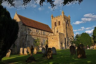
St Mary's Church is in the village of Chartham, Kent, England. It is an active Anglican parish church in the Diocese of Canterbury. Constructed between 1285 and circa 1305, with a later tower of the fourteenth century. In 1875, the church was restored by George Edmund Street. St Marys is designated by English Heritage as a Grade I listed building.

References

  1. Key Statistics; Quick Statistics: Population Density Archived 11 February 2003 at the Wayback Machine United Kingdom Census 2011 Office for National Statistics Retrieved 21 November 2013
  2. "Paper Manufacturer; Arjowiggins Creative Papers Suppliers of Translucent Paper". arjowiggins-tracingpapers.com. Retrieved 24 August 2012.
  3. Historic England. "Details from listed building database (1018874)". National Heritage List for England . Retrieved 23 May 2012.
  4. "Details of path, paper mills trail and local landmarks". Canterbury City Council. Archived from the original on 29 July 2012. Retrieved 23 May 2012.
  5. "Key Figures for 2011 Census: Key Statistics – Area: Chartham and Stone Street (Ward)". Neighbourhood Statistics. Office for National Statistics. Retrieved 20 January 2017.
  6. Vision of Britain (2009). "Chartham AP/CP". University of Portsmouth et al. chart view. Retrieved 12 June 2014.
  7. "Oldest 100 Ringing Bells in Kent". kent.lovesguide.com. 2010. Archived from the original on 6 June 2011. Retrieved 24 August 2012.
  8. 1 2 Chartham Parish Design Statement, Canterbury City Council & Chartham Society, March 2005
  9. Stephen Hart (18 March 2010). Medieval Church Window Tracery in England. Boydell & Brewer Ltd. p. 68. ISBN   9781843835332 . Retrieved 24 August 2012.
  10. Historic England. "Details from listed building database (1100352)". National Heritage List for England . Retrieved 23 May 2012.
  11. "Branch Finder". The Post Office. Retrieved 23 May 2012.
  12. Chartham Parish Council website [ permanent dead link ]
  13. Historic England. "Details from listed building database (1255391)". National Heritage List for England . Retrieved 23 May 2012.
  14. Historic England. "Details from listed building database (1085714)". National Heritage List for England . Retrieved 23 May 2012.
  15. "The Electronic Sawyer: Online Catalogue of Anglo-Saxon Charters. S319 dated 844". Archived from the original on 31 August 2018. Retrieved 2 July 2015.
  16. Historic England. "Details from listed building database (1085682)". National Heritage List for England . Retrieved 23 May 2012.
  17. Historic England. "Details from listed building database (1100332)". National Heritage List for England . Retrieved 23 May 2012.
  18. Historic England. "Details from listed building database (1085684)". National Heritage List for England . Retrieved 23 May 2012.
  19. Historic England. "Details from listed building database (1348494)". National Heritage List for England . Retrieved 23 May 2012.
  20. Historic England. "Details from listed building database (1336502)". National Heritage List for England . Retrieved 23 May 2012.
  21. Historic England. "Details from listed building database (1085685)". National Heritage List for England . Retrieved 23 May 2012.