
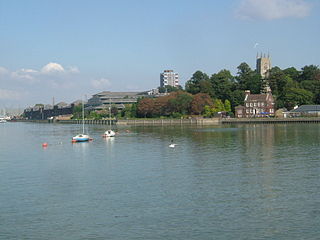
The River Stour is a river in Kent, England that flows into the North Sea at Pegwell Bay. Above Plucks Gutter, where the Little Stour joins it, the river is normally known as the Great Stour. The upper section of the river, above its confluence with the East Stour at Ashford is sometimes known as the Upper Great Stour or West Stour. In the tidal lower reaches, the artificial Stonar Cut short cuts a large loop in the natural river.

The River East Stour is one of the tributaries of the Great Stour in Kent. The East Stour, 10.3 miles (16.5 km) long,) rises on the Greensand ridge at Postling north of Hythe as a number of small streams. It then flows under the M20 motorway to continue in a westward direction: the river meanders across the Low Weald plain, passing Mersham on the way. The East Stour's confluence with the Great Stour is on both sides of Pledge's Mill at the foot of East Hill, Ashford.
The River Medway is a river in South East England. It rises in the High Weald, West Sussex and flows through Tonbridge, Maidstone and the Medway conurbation in Kent, before emptying into the Thames Estuary near Sheerness, a total distance of 70 miles (113 km). About 13 miles (21 km) of the river lies in East Sussex, with the remainder being in Kent.

The A20 is a major road in south-east England, carrying traffic from London to Dover in Kent. Parts of the route date back to turnpikes established in the early part of the 18th century. The line of the road throughout Kent runs closely in parallel with the M20 motorway.

Ashford is a town in the Ashford district, in the county of Kent, England. It lies on the River Great Stour at the southern or scarp edge of the North Downs, about 61 miles (98 km) by road southeast of central London and 15 miles (24 km) northwest of Folkestone by road. At the 2021 census, it had a population of 83,213. The name comes from the Old English æscet, indicating a ford near a clump of ash trees. It has been a market town since the Middle Ages, and a regular market continues to be held.

The Stour(, rhymes with "flour") is a river flowing through the counties of Worcestershire, the West Midlands and Staffordshire in the West Midlands region of England. The Stour is a major tributary of the River Severn, and is about 25 miles (40 km) in length. It has played a considerable part in the economic history of the region.

Four major rivers drain the county of Kent, England.
Willesborough is a village, now in effect a residential suburb, on the eastern side of Ashford, in the county of Kent, England.

Ashford is a constituency in Kent created in 1885 and represented in the House of Commons of the UK Parliament since 2024 by Sojan Joseph of the Labour Party.
The Stour Valley Walk is a recreational walking route that follows the River Stour, through the Low Weald and Kent Downs, from its source at Lenham to its estuary at Pegwell Bay.
Ashford Green Corridor is a green space that runs through the town of Ashford in Kent, England. The Green Corridor is made up of parks, recreation grounds and other green spaces alongside the rivers that flow through Ashford. It is a Local Nature Reserve.

Hothfield is a village and civil parish in the Ashford Borough of Kent, England and is 3 miles north-west of Ashford on the A20. It is completely split in two by Hothfield Common.
Ruckinge Dyke is a tributary of the Great Stour, joining with the East Stour and then the Great Stour at Pledge's Mill at the bottom of East Hill in Ashford, Kent, England.
Whitewater Dyke is a tributary of the Great Stour river, joining with the East Stour and then the Great Stour at Pledge's Mill at the bottom of East Hill in Ashford, Kent, England.
Brook Stream is a tributary of the Great Stour river in Ashford, Kent, England.
Shadoxhurst is a civil parish and a village on the remnant forest the Kent Weald, near Ashford in Kent, England between the Greensand Ridge and Romney Marsh.
The Smestow Brook, sometimes called the River Smestow, is a small river that plays an important part in the drainage of Wolverhampton, South Staffordshire, and parts of Dudley in the United Kingdom, and has contributed to the industrial development of the Black Country. It is the most important tributary of the River Stour, Worcestershire and part of the River Severn catchment.

Dorset is a county located in the middle of the south coast of England. It lies between the latitudes 50.512°N and 51.081°N and the longitudes 1.682°W and 2.958°W, and occupies an area of 2,653 km2. It spans 90 kilometres (56 mi) from east to west and 63 kilometres (39 mi) from north to south.

