
Sandwich is a town and civil parish in the Dover District of Kent, south-east England. It lies on the River Stour and has a population of 4,985. Sandwich was one of the Cinque Ports and still has many original medieval buildings, including several listed public houses and gates in the old town walls, churches, almshouses and the White Mill. While once a major port, it is now 2 miles (3 km) from the sea due to the disappearance of the Wantsum Channel. Its historic centre has been preserved. Sandwich Bay is home to nature reserves and two world-class golf courses, Royal St George's and Prince's. The town is also home to many educational and cultural events. Sandwich also gave its name to the food by way of John Montagu, 4th Earl of Sandwich, and the word sandwich is now found in several languages.

Minster, also known as Minster-in-Thanet, is a village and civil parish in the Thanet District of Kent, England. It is the site of Minster in Thanet Priory. The village is west of Ramsgate and to the north east of Canterbury; it lies just south west of Kent International Airport and just north of the River Stour. Minster is also the "ancient capital of Thanet". At the 2011 Census the hamlet of Ebbsfleet was included.
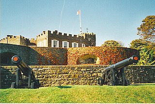
Walmer is a town in the district of Dover, Kent, in England. Located on the coast, the parish of Walmer is six miles (9.7 km) south-east of Sandwich, Kent. The town's coastline and castle are popular amongst tourists. It has a population of 6,693 (2001), increasing to 8,178 at the 2011 Census.
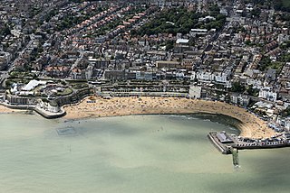
Broadstairs is a coastal town on the Isle of Thanet in the Thanet district of east Kent, England, about 80 miles (130 km) east of London. It is part of the civil parish of Broadstairs and St Peter's, which includes St Peter's, and had a population in 2011 of about 25,000. Situated between Margate and Ramsgate, Broadstairs is one of Thanet's seaside resorts, known as the "jewel in Thanet's crown". The town's coat of arms' Latin motto is Stella Maris. The name derives from a former flight of steps in the chalk cliff, which led from the sands up to the 11th-century shrine of St Mary on the cliff's summit.

Tenterden is a town and civil parish in the Borough of Ashford in Kent, England. The 2021 census published the population of the parish to be 8,186.

Reculver is a village and coastal resort about 3 miles (5 km) east of Herne Bay on the north coast of Kent in south-east England. It is in the ward of the same name, in the City of Canterbury district of Kent.

St Nicholas-at-Wade is both a village and a civil parish in the Thanet District of Kent, England. The parish had a recorded population of 782 at the 2001 Census, increasing to 852 at the 2011 census. The village of Sarre is part of the civil parish.

Sturry is a village on the Great Stour river situated 3 miles (4.8 km) northeast of Canterbury in Kent. Its large civil parish incorporates several hamlets and, until April 2019, the former mining village of Hersden.

Thanet is a local government district in Kent, England. The council is based in Margate and the district also contains the towns of Broadstairs, Ramsgate and Westgate-on-Sea, along with several villages. It takes its name from the Isle of Thanet, a former island which gradually became connected to the mainland between the 12th and 16th centuries.
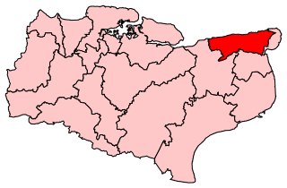
North Thanet was a constituency in Kent. It was represented in the House of Commons of the UK Parliament since its 1983 creation until abolition by Sir Roger Gale, a Conservative.
Isle of Thanet was a county constituency which returned one Member of Parliament (MP) to the House of Commons of the Parliament of the United Kingdom from 1885, until it was abolished for the February 1974 general election.

Woodchurch is a Kent village, the largest civil parish in the Borough of Ashford. It is centred 6 miles (9.7 km) from the market town of Ashford and 4 miles (6 km) from the Cinque Ports town of Tenterden, in Kent, South East England.

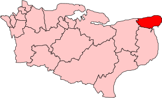
Thanet West was a British parliamentary constituency in the Isle of Thanet, in Kent.
Margate was a "limb" of Dover in the ancient confederation of the Cinque ports. It was added to the confederation in the 15th century.

Ringwould is a village and electoral ward near Deal in Kent, England. The coastal confederation of Cinque Ports during its mediaeval period consisted of a confederation of 42 towns and villages in all. This included Ringwould, as a 'limb' of Dover.
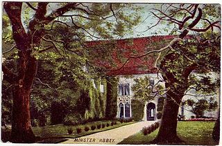
Minster Abbey is the name of two abbeys in Minster-in-Thanet, Kent, England. The first was a 7th-century foundation which lasted until the Dissolution of the Monasteries. Beside its ruins is St Mildred's Priory, a Benedictine community of women founded in 1937.
Sackett is an English surname originating in the Isle of Thanet, Kent, probably at Sackett's Hill in the parish of St Peter in Thanet. The earliest record of the name dates from 1317 when William Saket of Southborough, St Peter in Thanet, was in a legal dispute with the Abbot of St Augustine, Canterbury.

All Saints' Church, Shuart, in the north-west of the Isle of Thanet, Kent, in the south-east of England, was established in the Anglo-Saxon period as a chapel of ease for the parish of St Mary's Church, Reculver, which was centred on the north-eastern corner of mainland Kent, adjacent to the island. The Isle of Thanet was then separated from the mainland by the sea, which formed a strait known as the Wantsum Channel. The last church on the site was demolished by the early 17th century, and there is nothing remaining above ground to show that a church once stood there.

All Saints' Church, also known as Lydd Church or The Cathedral on the Marsh, is a church in Lydd, Kent, South East England. It belongs to the Diocese of Canterbury. All Saints is the longest parish church in Kent at 199 feet (61 m), and also has one of the tallest towers in the county at 132 feet (40 m). The church is thought to incorporate a small Romano-British basilica possibly built in the 5th century, though most of the current fabric is medieval. It was associated with local fraternities or guilds in the 15th century and could seat 1,000 people at a time. Severely damaged by World War II bombing, the church was subsequently restored and is now a Grade I listed building.

St Mary's Church, Reculver, was founded in the 7th century as either a minster or a monastery on the site of a Roman fort at Reculver, which was then at the north-eastern extremity of Kent in south-eastern England. In 669, the site of the fort was given for this purpose by King Ecgberht of Kent to a priest named Bassa, beginning a connection with Kentish kings that led to King Eadberht II of Kent being buried there in the 760s, and the church becoming very wealthy by the beginning of the 9th century. From the early 9th century to the 11th the church was treated as essentially a piece of property, with control passing between kings of Mercia, Wessex and England and the archbishops of Canterbury. Viking attacks may have extinguished the church's religious community in the 9th century, although an early 11th-century record indicates that the church was then in the hands of a dean accompanied by monks. By the time of Domesday Book, completed in 1086, St Mary's was serving as a parish church.


